The Blue Marble
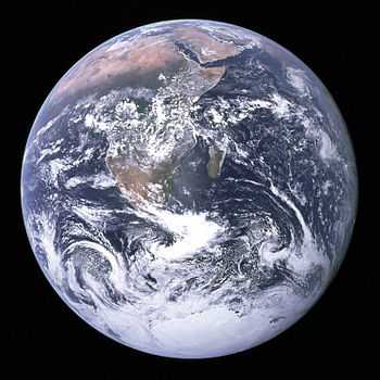
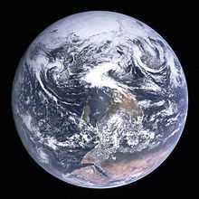
The Blue Marble is a famous photograph of the Earth, taken on December 7, 1972, by the crew of the Apollo 17 spacecraft, at a distance of about 45,000 kilometers (28,000 mi).[1]
The name has also been applied by NASA to a 2012 series of image data sets covering the entire globe at relatively high resolution, created by carefully sifting through satellite-captured sequences taken over time, to eliminate as much cloud cover as possible from the collated set of images.
In the original photograph, the South Pole was near the top; for publishing, NASA rotated the image 180 degrees, in accordance with the convention of orienting maps with north at the top.
The photograph
The snapshot—taken by astronauts on December 7, 1972, at 5:39 a.m. EST (10:39 UTC)—is one of the most widely distributed photographic images in existence.[2] The image is one of the few to show a fully illuminated Earth, as the astronauts had the Sun behind them when they took the image. To the astronauts, Earth had the appearance and size of a glass marble, hence the name.
History
The photograph was taken about 5 hours and 6 minutes after launch of the Apollo 17 mission,[3] and about 1 hour 54 minutes after the spacecraft left its parking orbit around the Earth, to begin its trajectory to the Moon. The time of Apollo 17's launch, 12:33 a.m. EST, meant that Africa was in daylight during the early hours of the spacecraft's flight. With the December solstice approaching, Antarctica was also illuminated.

An Indian Ocean cyclone can be seen in the top right of the image. This storm had brought flooding and high winds to the Indian state of Tamil Nadu on December 5, two days before the photograph was taken.[4]
The photograph's official NASA designation is AS17-148-22727. (NASA photograph AS17-148-22726, taken just before and nearly identical to 22727, is also used as a full-Earth image.) The photograph was originally oriented with the south pole at the top, with the island of Madagascar visible just left of center, and the continent of Africa at its right. However, the image was turned upside-down to fit the traditional view.[5]
The photographer used a 70-millimeter Hasselblad camera with an 80-millimeter Zeiss lens.[6][7] NASA officially credits the image to the entire Apollo 17 crew—Eugene Cernan, Ronald Evans and Jack Schmitt—all of whom took photographs during the mission with the on-board Hasselblad, although evidence examined after the mission suggests that Jack Schmitt was the photographer.[2]
Apollo 17 was the last manned lunar mission. No one since has been far enough from Earth to photograph a whole-Earth image such as The Blue Marble, but whole-Earth images have been taken by many unmanned spacecraft missions.
The Blue Marble was not the first clear image taken of an illuminated face of the Earth, since similar shots from satellites had already been made as early as 1967.[8] Counterculture activists had been among the first to cherish these images as icons of a new global consciousness.[9] The Apollo 17 image, however, released during a surge in environmental activism during the 1970s, was acclaimed by the wide public as a depiction of Earth's frailty, vulnerability, and isolation amid the vast expanse of space. NASA archivist Mike Gentry has speculated that The Blue Marble is the most widely distributed image in human history.[2]
The satellite imaging series


In 2002, NASA released an extensive set of satellite-captured imagery, including prepared images suitable for direct human viewing, as well as complete sets suitable for use in preparing further works.[10] At the time, 1 km/pixel was the most detailed imagery available for free, and permitted for reuse[11] without a need for extensive preparatory work to eliminate cloud cover and conceal missing data, or to parse specialized data formats. The data also included a similarly manually assembled cloud-cover and night-lights image sets, at lower resolutions.
A subsequent release was made in 2005, named Blue Marble Next Generation.[12] This series of photo mosaics was produced with the aid of automated image-sifting upon images from NASA's Earth Observatory, which enabled the inclusion of a complete, cloud-free globe 'frozen in time' for each month from January to December 2004, at even higher resolution (500 m/pixel).[13] The original release of a single-image set covering the entire globe had, of necessity, not been a true reflection of the extent of seasonal snow-and-vegetative cover across both hemispheres, but this newer release closely modeled the changes of the seasons.
A number of interactive viewers for these data have also been released, among them a music visualization for the PS3 that is based on the texture data.[14][15]
Other applications of the term "blue marble"

Subsequent similar images of Earth (including composites at much higher resolution) have also been termed "blue marble" images, and the phrase "blue marble" (as well as the picture itself) is frequently used, as in the Earth flag by environmental activist organizations or companies attempting to promote an environmentally conscious image. There has also been a children's television program called Big Blue Marble. Poet-diplomat Abhay K has penned an Earth Anthem inspired by the blue marble which contains "all the peoples and the nations of the world, one for all, all for one, united we unfurl the blue marble flag".[16]
Blue Marble 2012
On 25 January 2012, NASA released a composite image of the western hemisphere of Earth entitled Blue Marble 2012. The picture was widely viewed, logging over 3.1 million views on the Flickr image hosting website within the first week of release.[17] On 2 February 2012, NASA released a companion to this new Blue Marble, showing a composite image of the eastern hemisphere from data obtained on 23 January 2012.[18]
The picture is composed of data obtained by the Visible/Infrared Imager Radiometer Suite (VIIRS) instrument[18] on board the Suomi NPP satellite on 4 January 2012.[19] The data was obtained from six orbits of the Earth by the Suomi NPP over an eight hour period.[18]
Black Marble 2012
On December 5, 2012, NASA released a nighttime view of Earth called Black Marble[20] during an annual meeting of Earth scientists held by the American Geophysical Union in San Francisco.[21] The images display all the human and natural matter that glows and can be sensed from space.[22] The data was acquired by the Suomi NPP satellite in April and October 2012 and then mapped over existing Blue Marble imagery of Earth to provide a realistic view of the planet.[23] The Suomi NPP satellite completed 312 orbits and gathered 2.5 terabytes of data to get a clear shot of every parcel of the Earth’s land surface. Named for satellite meteorology pioneer Verner Suomi, the satellite flies over any given point on Earth’s surface twice each day and flies 512 miles above the surface in a polar orbit.[24]
According to NASA, the nighttime views were made possible by the new satellite’s “day-night band” of the Visible Infrared Imaging Radiometer Suite. The so-called VIIRS detects light in a range of wavelengths from green to near-infrared and uses filtering techniques to observe dim signals such as city lights, gas flares, auroras, wildfires, and reflected moonlight. Auroras, fires, and other stray light have been removed in the case of the Black Marble images to emphasize the city lights.[23] The NASA stated that nighttime images can be used for numerous purposes:
Social scientists and demographers have used night lights to model the spatial distribution of economic activity, of constructed surfaces, and of populations. Planners and environmental groups have used maps of lights to select sites for astronomical observatories and to monitor human development around parks and wildlife refuges. Electric power companies, emergency managers, and news media turn to night lights to observe blackouts.[23]
See also
- Deep Space Climate Observatory, an Earth observation and solar weather satellite, launched in February 2015 and due to be fully operational later that year, which will provide a near-continuous view of the entire sunlit-side of the Earth.
- Earth Anthem, an anthem by poet-diplomat Abhay K featuring the sentence "United we unfurl Blue Marble Flag".
- Earthrise, another iconic picture of the Earth, which was taken in 1968, aboard Apollo 8.
- Flag of the Earth, a proposal for which features the Blue Marble photo.
- Pale Blue Dot, an image of the Earth taken by Voyager 1.
- Stewart Brand, author who, in 1966, lobbied NASA to release a then-rumored satellite photograph of the entire Earth.
- The Day the Earth Smiled
- Whole Earth Catalog, an eclectic catalog compiled by Brand which was inspired in part by photographs of the Earth as a globe.
References
- ↑ Petsko, Gregory A (2011). "The blue marble". Genome Biology 12 (4): 112. doi:10.1186/gb-2011-12-4-112.
- ↑ 2.0 2.1 2.2 "Apollo 17: The Blue Marble". ehartwell.com. 2007-04-25. Retrieved 2008-01-18.
- ↑ "Apollo 17 Image Library". Apollo 17 Multimedia. NASA. Retrieved 2007-04-29.
- ↑ "History of Past Cyclones". Indian Meteorological Department. Retrieved 2011-09-16.
- ↑ "Worth a thousand worlds". Geek Trivia (TechRepublic). 2005-12-06. Archived from the original on 2012-06-29. Retrieved 2007-06-23.
- ↑ http://history.nasa.gov/alsj/a11/a11-hass.html
- ↑ NASA Mapping Sciences Branch (May 1974). Apollo 17 Index: 70 mm, 35 mm, and 16 mm Photographs. pp. 88. PDF.
- ↑ Images of the Earth taken from ATS-3 November 1967 till March 1969
- ↑ The front cover of the Fall 1968 edition of the Whole Earth Catalog showing the ATS-3 image of 10 Nov 1967
- ↑ "Blue Marble : Feature Articles". Earthobservatory.nasa.gov. 2005-10-13. Retrieved 2009-12-07.
- ↑ Christoph Hormann (2007-05-30). "Christoph's page — Earth — early renders". Imagico.de. Retrieved 2009-12-07.
- ↑ Blue Marble Next Generation Project
- ↑ Blue Marble Next Generation at NASA's Earth Observatory
- ↑ Gamasutra – Special: Q-Games On PS3's 'Gaia' Music Visualizer
- ↑ Blue Marble Next Generation : Feature Articles on Earthobservatory.nasa.gov
- ↑ An Anthem for the Earth The Kathmandu Post, May 25, 2013
- ↑ Kuring, Norman. "Most Amazing High Definition Image of Earth — Blue Marble 2012". NASA. Retrieved 12 February 2012.
- ↑ 18.0 18.1 18.2 "VIIRS Eastern Hemisphere Image — Behind the Scenes". NASA. Retrieved 12 February 2012.
|first1=missing|last1=in Authors list (help) - ↑ Kuring, Normar. "Blue Marble". NASA. Retrieved 12 February 2012.
- ↑ "NASA-NOAA Satellite Reveals New Views of Earth at Night". NASA. Retrieved 9 December 2012.
- ↑ "NASA Photos Show ‘Black Marble’ Earth at Night". ABC News. 5 December 2012. Retrieved 9 December 2012.
- ↑ Samenow, Jason (5 December 2012). "Satellites unveil Black Marble and spy on the moon". The Washington Post. Retrieved 9 December 2012.
- ↑ 23.0 23.1 23.2 "Black Marble – Americas". NASA. Flickr. Retrieved 9 December 2012.
- ↑ "‘Black Marble’ images shine light upon a sleeping world". The Washington Post. 5 December 2012. Retrieved 9 December 2012.
External links
| Wikimedia Commons has media related to The Blue Marble. |
- NASA history of Blue Marble image releases
1972 photograph
- The one, the only, photograph of Earth a short list of places in which the image has been used.
- Apollo Image Atlas Photos from magazine NN of the 70 mm Hasselblad camera used on Apollo 17 (includes the Blue Marble photo and others quite similar to it)
21st century NASA composite images
- Blue Marble (2002)
- Blue Marble Mapserver Web interface for viewing small sections of the above
- Blue Marble: Next Generation (2005; one picture per month)
- Blue Marble Navigator Web interface for viewing local sections of the above, incl. links to other such interfaces, download sites etc.
- Blue Marble: Next Generation in NASA World Wind
- Wired: New Satellite Takes Spectacular High-Res Image of Earth with link to 2012 Composite in Super High Resolution.
- "Earth at Night 2012: It’s the end of the night as you know it; you’ll see fine." from Michael Carlowicz at December 5, 2012 NASA Earth Observatory site with various links around the 2012 Black Marble images