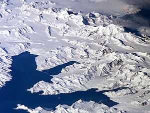
Thatcher Peninsula

Thatcher Peninsula (54°17′S 36°32′W / 54.283°S 36.533°WCoordinates: 54°17′S 36°32′W / 54.283°S 36.533°W) is a mountainous cove in north-central South Georgia terminating to the north in Mai Point, rising between Cumberland West Bay to the west, and Cumberland East Bay and Moraine Fjord to the east; bounded to the southwest and south by Lyell Glacier and Hamberg Glacier. King Edward Cove on the east side of the peninsula is the site of the British Antarctic Survey (BAS) Grytviken station and the disused whaling station of the same name.
Thatcher Peninsula was named by the United Kingdom Antarctic Place-Names Committee (UK-APC) in 1991, at the suggestion of members of the Royal Geographical Society, after Margaret Thatcher, British Prime Minister, 1979-1990. She was described by Sir Vivian Fuchs, chair of the Foreign Office's Antarctic Place Names Committee, as 'a major figure in the history of South Georgia', for her role in the Falklands War:[1] 'The geographical tribute appropriately encompasses the spot where the first troops from the Task Force landed in April 1982.'[2][3] Thatcher was, according to friends, 'flattered and amused' by the honour.[2]
References
![]() This article incorporates public domain material from the United States Geological Survey document "Thatcher Peninsula" (content from the Geographic Names Information System).
This article incorporates public domain material from the United States Geological Survey document "Thatcher Peninsula" (content from the Geographic Names Information System).
| ||||||||||||||||||||||||||