Thai Canal
The Thai Canal, also known as Kra Canal or Kra Isthmus Canal, refers to a plan for a large canal that would cut through southern Thailand to enable improved transportation in the region, like the Panama Canal and Suez Canal.
History
A canal through the Kra Isthmus, which would shorten shipping times around Asia, was suggested as early as 1677. The Thai King Narai the Great asked the French engineer de Lamar to survey the possibility of building a waterway to connect Songkhla with Marid (now Myanmar), but the idea was discarded as impractical with the technology of that time. In 1793, the idea resurfaced; the younger brother of King Chakri (Rama I) suggested it would make it easier to protect the western coast with military ships. In the early 19th century, the British East India Company became interested in a canal. After Burma became a British colony in 1863 with Victoria Point opposite the Kra estuary as its southernmost point, an exploration was undertaken, again with negative result. In 1882, the constructor of the Suez canal, Ferdinand de Lesseps, visited the area, but wasn't allowed to investigate in detail by the Thai king. In 1897, Thailand and the British empire agreed not to build a canal there, to protect the regional dominance of the harbour of Singapore.
Geography
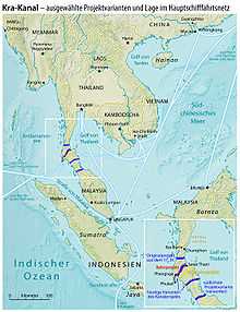
The width of the Kra Isthmus at its minimum is only 44 km (27 mi), but the height of the interior mountain chain is 75 m (246 ft) above sea level. Compare this to the Panama Canal: length of 77 km (48 mi), but highest point at the Culebra Cut was only 64 m (210 ft) above sea level. The Panama Canal passes this point at a height of 12 m (39 ft) (canal bottom) and 26 m (85 ft) (water line), thus ships have to be lifted with locks to a height of 26 m (85 ft) above the ocean. The Suez Canal is 192 km (119 mi) long but passes entirely through a flat area (which was historically flooded by seas before).
The length on land of a proposed Thai Canal could be anywhere between 50 and 100 km (30 and 60 mi)[1] depending on the route chosen. At a depth of 25 m (82 ft) below sea level the width of the Kra Isthmus is about 200 km (120 mi). [2] By 50 m (160 ft) below sea level this becomes about 400 km (250 mi). [3]
Competition with Strait of Malacca
As of 2011, an estimated 15.1 million barrels of oil pass through the Strait of Malacca,[4] which would be the canal's nearest alternative. Excluding port fees and tolls, it costs about US$0.00106 per ton-mile to operate a 265,000 DWT double-hulled tanker in 1995 dollars.[5] Thus, assuming a one-way distance saved of 600 kilometres (370 mi),[6][note 1] about 6.5 barrels per ton of crude oil,[7][note 2] and adjusting to 2011 dollars, the Thai canal could hypothetically reduce the cost of crude by about US$0.09 per barrel, which, if the entire traffic of the competing strait were diverted, would reduce in annual oil shipping costs by US$493 million, disregarding canal fees and the return trip costs of the empty tanker.
Recent developments
In the 20th century the idea resurfaced several times again, now changing the preferred route to somewhere in southern Thailand, to connect Bandon Bay near Surat Thani with Phang Nga. A Japanese plan for a canal in 1985 would have used over twenty nuclear devices each roughly twice the explosive energy of the bomb dropped on Hiroshima. The latest proposed site is across Nakhon Si Thammarat and Trang Provinces. If finished, it is believed that the canal would bring an economic boost to the nearby area and the whole country. The canal would compete directly with ports in the Strait of Malacca area, including Port Klang and Singapore. As such, there is a long standing rumor in the region that Singapore and Malaysia have been trying very hard to prevent the construction of the project by bribing Thai officials to vote against the construction of the project in the Bangkok parliament. The conspiracy theory is widely believed given the incentive that both of these countries have in protecting their own economy and industries who stand to lose a substantial sum of business if the project was erected.
As a substitute the construction of a land bridge was started in 1993, however as the location of the harbors wasn't fixed, highway 44 as the only finished part of the project now does not end at the sea yet. The two lanes were built 150 m apart to leave space for a railroad and eventually also a pipeline. Right now the highway runs from 8°18.11′N 98°47.03′E / 8.30183°N 98.78383°E to 9°9.47′N 99°31.02′E / 9.15783°N 99.51700°E and the project is stalled due to environmental concerns.
This is also a reason for recent interest in the canal. The Strait of Malacca, just under 1,000 kilometres (620 mi) long, is narrow, less than 2.5 kilometres (1.6 mi) at the narrowest, and just 25 metres (82 ft) deep at its shallowest point. It is heavily used by oil tankers and bulk carriers. Some 80 percent of Japan's oil supplies pass through the Straits. Any planned canal in Thailand would mean that large ships could travel through the region from India and on to China and Japan without passing through the Strait of Malacca.
In 2005 an internal report prepared for U.S. Secretary of Defense Donald Rumsfeld was leaked to The Washington Times, spelling out China's strategy of underwriting construction of the canal across the Kra Isthmus complete with Chinese port facilities and refineries, as part of its "string of pearls" strategy of forward bases and energy security.[8] The Chinese plan called for construction over ten years employing roughly 30,000 workers and costing between 20 and 25 billion US dollars.[9]
In early-2015, calls for yet another feasibility study of the canal have been put forward, a leading proponent being the Thai-Chinese Culture and Economic Association of Thailand (TCCEAT). Supporters of the canal believe that it would end Thailand's economic slump and make it a "global shipping and economic hub, rivalling the Panama Canal".[10]
References
Endnotes
- ↑ "India sees new strategic sea lane in Andaman Sea". Daily Times, Pakistan. September 30, 2005. Retrieved 2008-11-30.
- ↑ http://www.fieldmuseum.org/research_collections/zoology/zoo_sites/seamaps/images06/full/fig20%2009ka.jpg
- ↑ http://www.fieldmuseum.org/research_collections/zoology/zoo_sites/seamaps/images06/full/fig15%2011ka.jpg
- ↑ Strait of Malacca - World Oil Transit Chokepoints, Energy Information Administration, U.S. Department of Energy
- ↑ Characteristics and Changes in Freight Transportation Demand: Appendix F. - Estimating Transport Costs p. F-18. Cambridge Systematic, Inc.
- ↑ What will Thailand benefit from the Thai Canal project? Article by Assoc. Prof. Dr. Satapon Keovimol
- ↑ "How much, for what, and ending up where?". United Nations Environment Programme Global Marine Oil Pollution Information Gateway.
- ↑ "China calling: 'String of pearls'". Pittsburgh Tribune-Review. February 25, 2005. Retrieved 2007-11-01.
- ↑ Chaudhury, Dipanjan Roy (August 23, 2007). "Boosting Maritime Capabilities in the Indian Ocean". Worldpress.org. Retrieved 2007-11-01.
- ↑ Chongkittavorn, Kavi (2015-03-30). "Thailand ponders digging Kra Isthmus - again!". The Nation. Retrieved 30 Mar 2015.
Note
- ↑ Source says 1,200-1,300 km, however this appears to be a round-trip value (i.e., includes the return trip). The transportation cost source used does not appear to include the cost per mile of empty tankers, so we'll ignore the second half of the round trip for now.
- ↑ Source says 272 gal per ton; knowing that 1 barrel is 42 gal, we get 272/42 ~= 6.48.
Bibliography
- Thapa, Rajesh B.; M. Kusanagi, A. Kitazumi and Y. Murayama (October 2007). "Sea navigation, challenges and potentials in South East Asia: an assessment of suitable sites for a shipping canal in the South Thai Isthmus". GeoJournal 70: 161–172. doi:10.1007/s10708-008-9122-3.
- Cathcart, R.B. (2008). "Kra Canal (Thailand) excavation by nuclear-powered dredges". International Journal of Global Environmental Issues 8: 248–255. doi:10.1504/IJGENVI.2008.018639.
External links
- The Kra Canal:New Gateway to Maritime Silk Road
- Kra-Canal
- (Kra-Canal/ Thai-Canal)
- The Kra Canal and Southeast Asian Relations (academic article by Rini Suryati Sulong)
- Thai Canal project (Thai Language Site)