Texel
| Texel | |||
|---|---|---|---|
| Municipality | |||
|
Satellite image of Texel | |||
| |||
.svg.png) Location in North Holland | |||
| Coordinates: 53°3′N 4°48′E / 53.050°N 4.800°ECoordinates: 53°3′N 4°48′E / 53.050°N 4.800°E | |||
| Country | Netherlands | ||
| Province | North Holland | ||
| Government[1] | |||
| • Body | Municipal council | ||
| • Mayor | Francine Giskes (D66) | ||
| Area[2] | |||
| • Total | 463.16 km2 (178.83 sq mi) | ||
| • Land | 161.12 km2 (62.21 sq mi) | ||
| • Water | 302.04 km2 (116.62 sq mi) | ||
| Elevation[3] | 2 m (7 ft) | ||
| Population (May 2014)[4] | |||
| • Total | 13,641 | ||
| • Density | 85/km2 (220/sq mi) | ||
| Demonym | Tesselaar, Texelaar | ||
| Time zone | CET (UTC+1) | ||
| • Summer (DST) | CEST (UTC+2) | ||
| Postcode | 1790–1797 | ||
| Area code | 0222 | ||
| Website |
www | ||
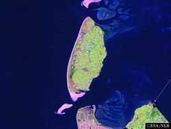


Texel (Dutch pronunciation: [ˈtɛsəl]) is a municipality and an island in the Netherlands, in the province of North Holland. It is the largest and most populated of the Frisian Islands in the Wadden Sea, and also the westernmost of this archipelago. The next island in the archipelago, to the north of Texel, is Vlieland.
The name Texel is Frisian, but because of historical sound-changes in Dutch, where all -x- sounds have been replaced with -s- sounds (compare for instance English Fox, Frisian Fokse, German Fuchs with Dutch Vos), the name is typically pronounced Tessel in Dutch.[5]
Geography
The island includes the seven villages De Cocksdorp, De Koog, De Waal, Den Burg, Den Hoorn, Oosterend, and Oudeschild, and the small townships of Bargen, De Nes, Dijkmanshuizen, Driehuizen, Harkebuurt, 't Horntje, Midden-Eierland, Molenbuurt, Nieuweschild, Noorderbuurt, Ongeren, Oost, Spang, Spijkdorp, Tienhoven, Westermient, Zevenhuizen, and Zuid-Eierland.
The municipality also includes the uninhabited sand bar of Noorderhaaks. The island of Texel, which received city rights in 1415, originally was made up of two islands, Texel proper to the south and Eierland to the northeast, which were connected by shoals. In the seventeenth century, the islands were poldered together. Today, Texel forms the largest natural barrier between the North Sea and the Wadden Sea.
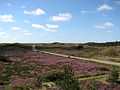
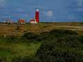
The dune landscape on Texel is a unique habitat for wildlife. Texel is known for its wildlife, particularly in winter, when birds of prey and geese take up residence. About one third of Texel is a protected nature reserve.
Transport
Transport around the island is typically by bicycle, bus (Texelhopper) or car. Texel has an extensive cycle path network. Transport to Texel is usually by ferry (Royal TESO), from Den Helder, or by air via Texel International Airport.
History
(Ludolf_Backhuysen%2C_1671).jpg)
In the early Middle Ages and before, Texel and Wieringen may have been much bigger and met each other as opposite banks of the Marsdiep, which was then a river with banks of permanent land: see here.
In the 13th Century Ada, Countess of Holland was held prisoner on Texel by her uncle William.
Notable battles involving Texel:
- 1653: Battle of Scheveningen, during the First Anglo-Dutch War
- 1673: Battle of Texel, during the Third Anglo-Dutch War
- 1797: Battle of Camperdown, during the Napoleonic wars
- 1914: Battle off Texel, during the First World War
- 1945: Georgian Uprising of Texel, during the Second World War
Texel is also famous in military history as the only place where a navy was defeated on horseback. Occupying Holland in January 1795, the French continental army learned that the mighty Dutch navy had been frozen into the ice around Texel, so Commandant Louis Joseph Lahure and 128 men rode up to it and demanded surrender. No shots were fired.
During the American Revolution, Texel was used as a haven port for the USS Bonhomme Richard before it sank off the coast of Flamborough Head in Britain in September 1779. In that final action, John Paul Jones defeated and captured the British ship HMS Serapis, which he sailed to Texel for desperately needed repairs. This event further complicated Anglo-Dutch relations.
On the night of 31 August 1940, the sea to the northwest of Texel was the scene of the sinking of two British destroyers and the severe damage of a third by German mines in what became known as the Texel Disaster.
Tourism
The tourism industry forms a substantial part of the economy in Texel. Approximately 70% of activities on Texel are in some way related to tourism. Popular forms of tourism on Texel include cycling, walking, swimming and horse riding.
As in much of Northern Holland, many of the residents can communicate in English but most travel literature and restaurant menus are in the Dutch and German languages only. The VVV tourist information centres though are very helpful.
Local government
The municipal council of Texel consists of 15 seats, which are divided as follows [as of April 2014]:
- VVD, 3 seats
- PvdA, 3 seats
- Texel 2010, 2 seats
- CDA, 1 seat
- Texels Belang, 3 seats
- D66, 1 seat
- GroenLinks, 1 seat
- Sterk Texel, 1 seat
Climate
| Climate data for Texel | |||||||||||||
|---|---|---|---|---|---|---|---|---|---|---|---|---|---|
| Month | Jan | Feb | Mar | Apr | May | Jun | Jul | Aug | Sep | Oct | Nov | Dec | Year |
| Record high °C (°F) | 13.3 (55.9) |
14.9 (58.8) |
20.5 (68.9) |
25.5 (77.9) |
28.5 (83.3) |
31.7 (89.1) |
31.7 (89.1) |
33.8 (92.8) |
28.5 (83.3) |
24.2 (75.6) |
16.6 (61.9) |
13.8 (56.8) |
33.8 (92.8) |
| Average high °C (°F) | 5.5 (41.9) |
5.5 (41.9) |
8 (46) |
11.5 (52.7) |
15.5 (59.9) |
18 (64) |
20.5 (68.9) |
20.5 (68.9) |
18 (64) |
14 (57) |
9.5 (49.1) |
6 (43) |
12.71 (54.78) |
| Average low °C (°F) | 1 (34) |
0.5 (32.9) |
2.5 (36.5) |
5 (41) |
7.5 (45.5) |
11.5 (52.7) |
13.5 (56.3) |
14 (57) |
11.5 (52.7) |
8.5 (47.3) |
5 (41) |
2 (36) |
6.88 (44.41) |
| Record low °C (°F) | −18.8 (−1.8) |
−13.4 (7.9) |
−8.0 (17.6) |
−4.8 (23.4) |
−0.4 (31.3) |
1.5 (34.7) |
5.2 (41.4) |
5.6 (42.1) |
3.4 (38.1) |
−2.4 (27.7) |
−6.4 (20.5) |
−10.0 (14) |
−18.8 (−1.8) |
| Average precipitation mm (inches) | 70 (2.76) |
50 (1.97) |
60 (2.36) |
35 (1.38) |
50 (1.97) |
50 (1.97) |
65 (2.56) |
70 (2.76) |
90 (3.54) |
100 (3.94) |
95 (3.74) |
80 (3.15) |
815 (32.1) |
| Mean monthly sunshine hours | 60 | 95 | 135 | 195 | 235 | 220 | 225 | 205 | 145 | 110 | 60 | 50 | 1,735 |
| Source #1: [6] | |||||||||||||
| Source #2: [7] | |||||||||||||
Gallery
-

New 2005 Ferry "Dokter Wagemaker" from Den Helder to Texel
-
-
-
-
-
-

See also
- Texel (sheep), a breed of sheep from Texel
References
- ↑ "B&W samenstelling en portefeuilles" [Mayor and aldermen members and tasks] (in Dutch). Gemeente Texel. Retrieved 22 March 2014.
- ↑ "Kerncijfers wijken en buurten" [Key figures for neighbourhoods]. CBS Statline (in Dutch). CBS. 2 July 2013. Retrieved 12 March 2014.
- ↑ "Postcodetool for 1791AT". Actueel Hoogtebestand Nederland (in Dutch). Het Waterschapshuis. Retrieved 22 March 2014.
- ↑ "Bevolkingsontwikkeling; regio per maand" [Population growth; regions per month]. CBS Statline (in Dutch). CBS. 26 June 2014. Retrieved 24 July 2014.
- ↑ Donaldson, BC: Dutch: A Linguistic History of Holland and Belgium, page 151, Martinus Nijhoff, 1983
- ↑ "Klimaatatlas| KNMI". knmi.nl. Retrieved 2015-03-08.
- ↑ "Extremen 1971-2000 per station" (PDF). knmi.nl. Retrieved 2015-03-09.
External links
 Media related to Texel at Wikimedia Commons
- Official website
 |
Vlieland (FR) Eijerlandsegat |
| ||
| North Sea | |
Wadden Sea | ||
| ||||
| | ||||
| Marsdiep Den Helder |

| ||||||||||||||||||||||||||||||||||||||||||||||||||||||||

| ||||||||||||||