Teuchezhsky District
| Teuchezhsky District Теучежский район (Russian) Теуцожь район (Adyghe) | |
|---|---|
 Location of Teuchezhsky District in the Republic of Adygea | |
| Coordinates: 44°53′06″N 39°23′24″E / 44.88500°N 39.39000°ECoordinates: 44°53′06″N 39°23′24″E / 44.88500°N 39.39000°E | |
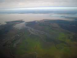 Aerial view of the auls of Pshikuykhabl (left) and Tauykhabl (right) near Krasnodar Reservoir in Teuchezhsky District | |
 | |
|
| |
| Holiday | Second Saturday of September |
| Location | |
| Country | Russia |
| Federal subject | Republic of Adygea[1] |
| Administrative structure (as of June 2012) | |
| Administrative center | aul of Ponezhukay[1] |
| Inhabited localities: | |
| Urban-type settlements | 1 |
| Rural localities | 26 |
| Municipal structure (as of December 2004) | |
| Municipally incorporated as | Teuchezhsky Municipal District[2] |
| Municipal divisions:[2] | |
| Urban settlements | 1 |
| Rural settlements | 6 |
| Local government: | |
| Head[3] | Azamat Khachmamuk[3] |
| Statistics | |
| Area | 700 km2 (270 sq mi)[4] |
| Population (2010 Census) | 20,643 inhabitants[5] |
| - Urban | 26.2% |
| - Rural | 73.8% |
| Density | 29.49/km2 (76.4/sq mi)[6] |
| Time zone | MSK (UTC+03:00)[7] |
| Established |
February 7, 1929 (first),[8] August 5, 1957 (second)[8] |
| Official website | |
| Teuchezhsky District on WikiCommons | |
Teuchezhsky District (Russian: Теуче́жский райо́н; Adyghe: Теуцожь район) is an administrative[1] and a municipal[2] district (raion), one of the seven in the Republic of Adygea, Russia. It is located in the west of the republic and borders with the territory of the City of Krasnodar of Krasnodar Krai, Krasnodar Reservoir, and Krasnogvardeysky District in the north, Belorechensky District of Krasnodar Krai in the east and southeast, the territory of the Town of Goryachy Klyuch of Krasnodar Krai in the south, and with Takhtamukaysky District in the west. The area of the district is 700 square kilometers (270 sq mi).[4] Its administrative center is the rural locality (an aul) of Ponezhukay. District's population: 20,643 (2010 Census);[5] 19,951 (2002 Census);[9] 21,929 (1989 Census).[10] The population of Ponezhukay accounts for 16.7% of the district's total population.[5]
History
The district was established on February 7, 1929 as Psekupsky District (Псекупский район) and was renamed Ponezhukaysky (Понежукайский район) in 1938 and Teuchezhsky in 1940.[8] The district was merged into Takhtamukaysky District on December 7, 1956.[8] It was, however, restored shortly thereafter on August 5, 1957.[8]
Divisions
Administrative divisions
Teuchezhsky District has administrative jurisdiction over one urban-type settlement (with one rural locality in its jurisdiction) and twenty-five rural localities.
Municipal divisions
Municipally, the district is divided into one urban settlement and six rural settlements:[2]
- Urban settlements
- Tlyustenkhablskoye (Тлюстенхабльское)
- urban-type settlement of Tlyustenkhabl
- rural localities under jurisdiction of the urban-type settlement:
- aul of Tugurgoy
- Rural settlements
- Assokolayskoye (Ассоколайское)
- Gabukayskoye (Габукайское)
- Administrative center: aul of Gabukay
- other localities of the rural settlement:
- khutor of Chabanov
- khutor of Petrov
- khutor of Shevchenko
- Dzhidzhikhablskoye (Джиджихабльское)
- Administrative center: aul of Dzhidzhikhabl
- other localities of the rural settlement:
- khutor of Gorodskoy
- aul of Kunchukokhabl
- aul of Tauykhabl
- Pchegatlukayskoye (Пчегатлукайское)
- Administrative center: aul of Pchegatlukay
- other localities of the rural settlement:
- settlement of Chetuk
- khutor of Kazazov
- khutor of Kochkin, Pchegatlukayskoye Rural Settlement
- khutor of Krasnensky
- Ponezhukayskoye (Понежукайское)
- Administrative center: aul of Ponezhukay
- other localities of the rural settlement:
- khutor of Kochkin, Ponezhukayskoye Rural Settlement
- khutor of Kolos
- aul of Nachereziy
- aul of Nezhukay
- aul of Pshikuykhabl
- khutor of Shunduk
- settlement of Zarya
- Vochepshiyskoye (Вочепшийское)
- Administrative center: aul of Vochepshiy
- other localities of the rural settlement:
- khutor of Novovochepshiy
References
Notes
- ↑ 1.0 1.1 1.2 Law #171
- ↑ 2.0 2.1 2.2 2.3 Law #284
- ↑ 3.0 3.1 Official website of Teuchezhsky District. Azamat Shamsudinovich Khachmamuk, Head of the Administration (Russian)
- ↑ 4.0 4.1 Official website of Teuchezhsky District. Economy of the District (Russian)
- ↑ 5.0 5.1 5.2 Russian Federal State Statistics Service (2011). "Всероссийская перепись населения 2010 года. Том 1" [2010 All-Russian Population Census, vol. 1]. Всероссийская перепись населения 2010 года (2010 All-Russia Population Census) (in Russian). Federal State Statistics Service. Retrieved June 29, 2012.
- ↑ The value of density was calculated automatically by dividing the 2010 Census population by the area specified in the infobox. Please note that this value may not be accurate as the area specified in the infobox does not necessarily correspond to the area of the entity proper or is reported for the same year as the population.
- ↑ Правительство Российской Федерации. Федеральный закон №107-ФЗ от 3 июня 2011 г. «Об исчислении времени», в ред. Федерального закона №248-ФЗ от 21 июля 2014 г. «О внесении изменений в Федеральный закон "Об исчислении времени"». Вступил в силу по истечении шестидесяти дней после дня официального опубликования (6 августа 2011 г.). Опубликован: "Российская газета", №120, 6 июня 2011 г. (Government of the Russian Federation. Federal Law #107-FZ of June 31, 2011 On Calculating Time, as amended by the Federal Law #248-FZ of July 21, 2014 On Amending Federal Law "On Calculating Time". Effective as of after sixty days following the day of the official publication.).
- ↑ 8.0 8.1 8.2 8.3 8.4 Азаренкова, А. С.; И. Ю. Бондарь, Н. С. Вертышева (1986) [1986]. Основные административно-территориальные преобразования на Кубани (1793–1985 гг.) (in Russian). Краснодарское книжное издательство. p. 181.
- ↑ Russian Federal State Statistics Service (May 21, 2004). "Численность населения России, субъектов Российской Федерации в составе федеральных округов, районов, городских поселений, сельских населённых пунктов – районных центров и сельских населённых пунктов с населением 3 тысячи и более человек" [Population of Russia, Its Federal Districts, Federal Subjects, Districts, Urban Localities, Rural Localities—Administrative Centers, and Rural Localities with Population of Over 3,000] (XLS). Всероссийская перепись населения 2002 года [All-Russia Population Census of 2002] (in Russian). Retrieved August 9, 2014.
- ↑ Demoscope Weekly (1989). "Всесоюзная перепись населения 1989 г. Численность наличного населения союзных и автономных республик, автономных областей и округов, краёв, областей, районов, городских поселений и сёл-райцентров" [All Union Population Census of 1989: Present Population of Union and Autonomous Republics, Autonomous Oblasts and Okrugs, Krais, Oblasts, Districts, Urban Settlements, and Villages Serving as District Administrative Centers]. Всесоюзная перепись населения 1989 года[All-Union Population Census of 1989] (in Russian). Институт демографии Национального исследовательского университета: Высшая школа экономики [Institute of Demography at the National Research University: Higher School of Economics]. Retrieved August 9, 2014.
Sources
- Государственный Совет — Хасэ Республики Адыгея. Закон №171 от 5 мая 2000 г. «Об административно-территориальном устройстве Республики Адыгея», в ред. Закона №97 от 6 июня 2012 г. «О внесении изменений в некоторые Законы Республики Адыгея в связи с принятием Закона Республики Адыгея "Об отнесении посёлка городского типа Тульского к категории посёлков — сельских населённых пунктов"». Вступил в силу со дня официального опубликования. Опубликован: "Советская Адыгея", №156-157, 7 августа 2004 г. (State Assembly of the Republic of Adygea. Law #171 of May 5, 2000 On the Administrative-Territorial Structure of the Republic of Adygea, as amended by the Law #97 of June 6, 2012 On Amending Various Laws of the Republic of Adygea Due to the Adoption of the Law of the Republic of Adygea "On Transformation of the Urban-Type Settlement of Tulsky into a Settlement—a Rural Locality. Effective as of the official publication date.).
- Совет Республики Адыгея. Закон №284 от 30 декабря 2004 г. «О наделении муниципального образования "Теучежский район" статусом муниципального района, об образовании муниципальных образований в его составе и установлении их границ», в ред. Закона №358 от 18 декабря 2014 г. «О внесении изменений в Закон Республики Адыгея "О наделении муниципального образования "Теучежский район" статусом муниципального района, об образовании муниципальных образований в его составе и установлении их границ"». Вступил в силу со дня официального опубликования. Опубликован: "Советская Адыгея", №2–5, 12 января 2005 г. (Council of the Republic of Adygea. Law #284 of December 30, 2004 On Granting Municipal District Status to the Municipal Formation of "Teuchezhsky District", on Establishing Municipal Formations Within Its Structure, and on Establishing Their Borders, as amended by the Law #358 of December 18, 2014 On Amending the Law of the Republic of Adygea "On Granting Municipal District Status to the Municipal Formation of "Teuchezhsky District", on Establishing Municipal Formations Within Its Structure, and on Establishing Their Borders". Effective as of the day of the official publication.).
| ||||||||||||||||||||||||