Terskey Alatau
| Teskey Ala-Too | |
|---|---|
|
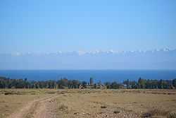
Terskey Alatau range seen from across Issyk Kul Lake | |
| Highest point | |
| Peak | Boris Yeltsin Peak |
| Elevation | 5,216 m (17,113 ft) |
| Dimensions | |
| Length | 354 km (220 mi) E-W |
| Width | 40 km (25 mi) N-S |
| Naming | |
| Native name | Тескей Ала-Тоо |
| Geography | |
| Country | Kyrgyzstan |
| State/Province | Issyk Kul Province |
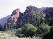
Broken Heart Rock, in the Jety-Oguz Valley in the Terskey Ala-Too
The Teskey Ala-Too or Terskey Ala-Too (Kyrgyz: Тескей Ала-Тоосу, [teskéj ɑlɑtoːsú]) is a mountain range in Kyrgyzstan's Tien-Shan that borders Issyk Kul and Kochkor Valley from the south. The length of the range is 354 km and highest peak - Boris Yeltsin Peak (5,216 m).[1]
Geology
Terskey Ala-Too is composed of granites and granodiorites of Caledonian, and granites, metamorphic schists, quartzites, sandstones, and limestones of Paleozoic.
References
| Wikimedia Commons has media related to Terskey Alatau. |