Teneguía
| Teneguía | |
|---|---|
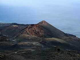 The volcano of Teneguia in 2012. | |
| Elevation | 439 m (1,440 ft)[1] |
| Location | |
| Location | La Palma, Canary Islands, Spain |
| Coordinates | 28°28′N 17°51′W / 28.467°N 17.850°WCoordinates: 28°28′N 17°51′W / 28.467°N 17.850°W |
| Geology | |
| Type | Cinder cone [1] |
| Last eruption | October to November 1971[2] |
Teneguía is a cinder cone [1] volcano situated on the island of La Palma, one of the Canary Islands. It is located at the southern end of the sub-aerial section of the Cumbre Vieja of which Teneguía is one of several vents.
1971 Eruption
This volcano is the source of the last subaerial volcanic eruption on Spanish soil –from October 26 to November 28, 1971. Earthquakes preceded the eruption. The eruption killed an elderly fisherman who had come too close to the lava and was asphyxiated. The El Hierro eruption of 2011-2012 was a submarine eruption.
The eruption also caused some property damage and destroyed a beach, though a new one was later formed by natural means. Populated zones were not affected. It has also been predicted that the volcano will show some more activity and is a possibility of a land slide causing some of the island to fall off. This will cause a tsunami. It's most likely going to destroy a lot of south England and the east coast of America. The governments of both countries are quite aware. New York have already carried out evacuation plans.
The volcano has become a spot for tourism and forms part of the Monumento Natural de Los Volcanes de Teneguía.
References
Scarth, Alwyn; Tanguy, Jean-Claude (2001). Volcanoes of Europe. Oxford University Press. p. 243 pp. ISBN 0-19-521754-3.
- ↑ 1.0 1.1 1.2 "Global Volcanism Program - La Palma". Volcano.si.edu. Retrieved 16 February 2015.
- ↑ "Global Volcanism Program - La Palma". Volcano.si.edu. Retrieved 16 February 2015.