Temperate climate

| Part of the nature series |
| Weather |
|---|
| Calendar seasons |
| Tropical seasons |
| Storms |
| Precipitation |
| Topics |
| Weather portal |
In geography, temperate or tepid latitudes of Earth lie between the tropics and the polar regions.[1] The temperatures in these regions are generally relatively moderate, rather than extremely hot or cold, and the changes between summer and winter are also usually moderate.
Zones and climate
The north temperate zone extends from the Tropic of Cancer (approximately 23.5° north latitude) to the Arctic Circle (approximately 66.5° north latitude). The south temperate zone extends from the Tropic of Capricorn (approximately 23.5° south latitude) to the Antarctic Circle (at approximately 66.5° south latitude).[2][3]
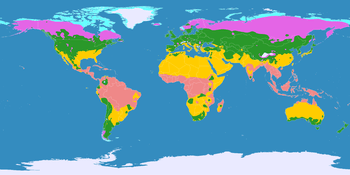
The Temperate climate zone is normally divided into two types of climates:
1)Temperate Continental climates (which include arid climates within the Temperate zone), are normally located between 35 or 40 and 55 north latitude on the eastern side or interior of the large landmasses in Asia, Europe, and North America (no Temperate Continental climates occur in the southern Hemisphere). In this climate zone, summers are warm (to hot in some areas), and winters often long, cold, and snowy (in the more humid sectors). [4][5][6]
2)Temperate Oceanic Climates are normally located between 45 and 58 north latitude on the west sides or west coastal areas of the large landmasses in Asia, Europe, North America, extreme South America, and South Island, New Zealand. In this climate zone, summers are cool, and winters are cool, but not cold, and there is little frozen precipitation at lower elevations. Located in the higher latitudes on the windward sides of landmass, some oceanic climates can have much cloudy and overcast skies.
The vast majority of the world's human population resides in temperate zones, especially in the northern hemisphere because of its greater mass of land.[7]
See also
- Geographical zone
- Middle latitudes
- Habitat (ecology)
- Polar circle
- Subtropics
References
- ↑ Education Scotland. "Weather & climate Change Climates around the world". educationscotland.gov.uk.
- ↑ McColl, R. W. (2005). Encyclopedia of World Geography, Volume 1. (Facts on File Library of World Geography). New York: Facts on File. p. 919. ISBN 0-816-05786-9.
- ↑ "Solar Illumination: Seasonal and Diurnal Patterns". Encyclopedia.com. Retrieved October 4, 2012.
- ↑ "Köppen Climate Classification: The Temperate Climate". The International Sustainability Council - Audubon. 2008. Retrieved July 6, 2014.
...the north-south aligned Rocky Mountains act as a climate barrier to the mild maritime air blowing from the west.
- ↑ "Climate of Switzerland". Swiss University. Retrieved October 4, 2012.
The Alps act as a climate barrier: Southern Switzerland, which is mainly influenced by the Mediterranean Sea, is characterized by a much milder climate than Northern Switzerland.
- ↑ Brinch, Brian (2007-11-01). "How mountains influence rainfall patterns". USA Today (Tysons Corner, Virginia: Gannett). ISSN 0734-7456. Retrieved October 4, 2012.
As air ascends mountains, such as the Washington Cascades, it is forced to rise. The rising air cools, condenses, and drops rain on locations situated on the windward slopes, like Seattle. When the air descends the back side of the mountain toward Spokane, it is compressed, warming and drying it out. This sinking, dry air produces a rain shadow, or area in the lee of a mountain with less rain and cloudcover.
- ↑ Cohen, Joel E.; Christopher Small (November 24, 1998). "Hypsographic demography: The distribution of human population by altitude". Proceedings of the National Academy of Sciences of the United States of America, Vol. 95. Washington, D.C.: The Academy. pp. 14009–14014. Retrieved September 19, 2012.
| ||||||||||||||||
| ||||||||||||||||||||||