Teluk Sengat
| Teluk Sengat | |
|---|---|
|
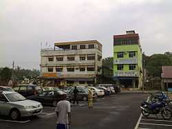
View of the business buildings in Teluk Sengat | |
| Coordinates: 13°50′S 171°45′W / 13.833°S 171.750°WCoordinates: 13°50′S 171°45′W / 13.833°S 171.750°W | |
| Country |
|
| District | Kota Tinggi |
| Founded | 1650s |
| Became Capital | 1959 |
| Area | |
| • Urban | 20 sq mi (60 km2) |
| Elevation[1] | 3 ft (1 m) |
| Population (2001) | |
| • Urban | 58,800 |
| • Urban density | 2,534.48/sq mi (978.57/km2) |
| Time zone | SST (UTC-11) |
| • Summer (DST) | HST[2] (UTC-10) |
Teluk Sengat is a small town in Kota Tinggi district, Johor, Malaysia. Near the town is the Johor Lama fort. The main economic activity in this town is fishing. There are also palm oil estate nearby and a remote village named Kampung Guntong Nanas.
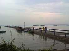
Jetty in Teluk Sengat
References
- ↑ "Weather Underground: Apia, Samoa".
- ↑ "Samoa Starts Daylight Saving Time in 2009". timeanddate.com. 2008-11-28. Retrieved 2009-08-03.