Telica (volcano)
| Telica | |
|---|---|
| Volcán Telica | |
 Telica | |
| Elevation | 1,061 m (3,481 ft) |
| Location | |
 Telica Location in Nicaragua | |
| Location | León Department, Nicaragua |
| Coordinates | 12°36′07″N 86°50′42″W / 12.602°N 86.845°WCoordinates: 12°36′07″N 86°50′42″W / 12.602°N 86.845°W |
| Geology | |
| Type | Stratovolcano |
| Last eruption | May to June 2011 |
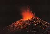
Telica (Spanish: Volcán Telica)[1] is a stratovolcano, one of several volcanoes of the Nicaraguan volcanic front. It is located in Telica municipality, in the León department of Nicaragua.[2] One of Nicaragua's most active volcanoes, Telica has erupted frequently, and ash from those frequent eruptions keeps the slopes of its cone bare of vegetation.[3]
Volcanism
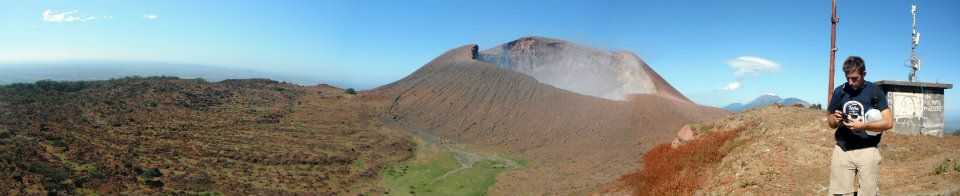
Telica has six cones, the tallest of which is 1061 meters high. There is a double crater at the top, 700 meters wide and 120 meters deep.[2] Telica has erupted frequently since the Spanish Era.[2] The most recent eruption was in 2011.
In terms of explosive force, Telica's largest eruption has been rated with a VEI of 4. That eruption occurred in 1529.[4]
Tourism
The general proximity to the city of León makes Telica a popular tourist attraction. Several tourism agencies offer the trek as a two-day tour. The trek is moderately strenuous, taking approximately 5 hours one-way.[5]
High temperatures, lack of water access and trail markers make the hike slightly more difficult. Most hikes enter through the small town of San Jacinto, known for its bubbling mud pits and small geothermal electric generation plant.
See also
External links
References
- ↑ "Volcán Telica: Nicaragua". Geographical Names. Retrieved 2011-02-07.
- ↑ 2.0 2.1 2.2 "Telica". Global Volcanism Program. Retrieved 2011-02-09.
- ↑ "Telica Volcano, Nicaragua". Volcano Photos. Retrieved 2011-02-10.
- ↑ "Large Volcano Explocivity Index". Allcountries.org. Retrieved 2011-02-10.
- ↑ "Volcán Telica". Quetzaltrekkers. Retrieved 2011-02-09.
| |||||||||||||||||||||||||||||