Telêmaco Borba
| Telêmaco Borba | |||
|---|---|---|---|
| Municipality | |||
| |||
| Nickname(s): Capital do Papel | |||
| Country |
| ||
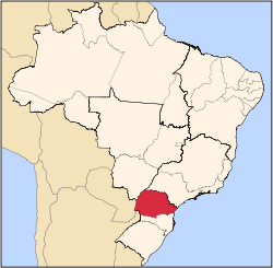
| Region | Southern | ||
| State | Paraná | ||
| Mesoregion | Centro Oriental Paranaense | ||
| Government | |||
| • Mayor | Luiz Carlos Gibson | ||
| Population | |||
| • Total | 75.054 | ||
| Time zone | UTC -3 | ||


Telêmaco Borba is a municipality in the state of Paraná in the Southern Region of Brazil.
Telêmaco Borba is known as the Capital of Paper (Capital do Papel) due to the importance of paper production to the local economy.
City
Telêmaco Borba is the second largest city in Campos Gerais, it had a population 75.054 in 2014,[1] according to the estimate. Telêmaco Borba is highly urbanised, since only 2400 residents live in the countryside.
The city was founded because of Klabin Papel e Celulose Industry in the early 1940s. Their factory is the largest producer, exporter and recycler of paper in Brazil.
Today, the city is the 6th largest Industrial Center in Paraná, thanks to paper/lumber sector. That's why the city is the "Paper and Timber Capital". Telêmaco Borba is a national reference is this sector, and also an important regional center in many areas, among them, health and education.
The city is served by Telêmaco Borba Airport.[2][3][4][5]
History
With the installation of Klabin Industries in Tibagi, encampments arose as Harmonia, Lagoa, Antas, Maua, Mandaçaia, Miranda, Mirandinha. Klabin later bought the land on the left bank of the Tibagi River, the facilities front of Paper Mill and Pulp. Klabin, created the Cia. Territorial Tibagi Valley, which was responsible for urban development and subdivision of land.
The new residents, the vast majority of employees Klabin, started calling the town of New Town. The New Town was an early development than in July 25, 1960 signed by the governor Moyses Lupion, was elevated to a municipality under the name of Telêmaco Borba, with territory taken from the municipality of Tibagi.
However, the city was never even installed, since the Legislative Assembly of the State of Paraná, revoked item IV of article 1 of Law No. 4245, of July 25, 1960 and therefore was extinguished municipality of Telêmaco Borba, returning to the status of mere district with territory belonging to the municipality of Tibagi again, and resuming its former name of New Town.
By State Law No. 4,445, of October 16, 1961, the Administrative District of New Town was created in the municipality of Tibagi. On July 5, 1963, by State Law No. 4738, signed by the governor Ney Aminthas de Barros Braga, the district was elevated to municipality emancipated, with territory taken from the municipality of Tibagy, but with the name changed again to definitely Telêmaco Borba. The county name is a tribute to Colonel Telêmaco Augusto Enéas Morosini Borba.
Geography
Hydrography
- Alegre River
- Harmonia River
- Imbaú River
- Imbaúzinho River
- Tibagi River
Tourism
- Air tram Telemaco Borba (Cable Car)
- Harmonia Grove
- Municipal Environmental Park Pedro Cortez
- Municipal Tibagi River Park
- Samuel Klabin Ecological Park
- Luba Klabin Square (Praça dos Pinheiros)
- Square Dr. Horacio Klabin
- Interpretation Centre of Nature Frans Krajcbeg
- Craftsman House
- Quail White Sulfurosa Water Supply
- Catholic Church Nossa Senhora do Perpétuo Socorro
- Municipal Museum of Telemaco Borba
- Museum of Fauna and Flora
- Lake of the House of Culture Square
- Mandaçaia pond
- Mandaçaia cave
- Conceição of the jump
- Mauá Plant Dam
Education
- Paraná Federal Institute of Education, Science and Technology (IFPR) - Instituto Federal de Educação, Ciência e Tecnologia do Paraná - campus of Telêmaco Borba;
- Ponta Grossa State University (UEPG) (Pt: Universidade Estadual de Ponta Grossa) - campus of Telêmaco Borba
- Universidade Anhanguera (Uniderp) - campus universitário of Telêmaco Borba;
- Faculdade de Telêmaco Borba (Fateb)- campus Carlos Hugo Wolff Von Graffen;
Highways
- PR-160 - Imbaú-Telêmaco Borba and Telêmaco Borba-Curiúva.
- PR-340 - Tibagi-Telêmaco Borba and Telêmaco Borba-Ortigueira.
- PR-239 - Ventania-Telêmaco Borba (Lagoa).
- BR-153 - Tibagi-Ventania.
Notable people
- Thiago Kosloski - footballer
- Dayenne Mesquita - Actress
See also
External links
References
- ↑ "Estimativas da população para 1º de julho de 2014" (PDF) (in Portuguese). Estimativas de População, Instituto Brasileiro de Geografia e Estatística (IBGE). August 28, 2014. Retrieved October 25, 2014.
- ↑ "Divisão Territorial do Brasil" (in Portuguese). Divisão Territorial do Brasil e Limites Territoriais, Instituto Brasileiro de Geografia e Estatística (IBGE). July 1, 2008. Retrieved December 17, 2009.
- ↑ "Ranking decrescente do IDH-M dos municípios do Brasil" (in Portuguese). Atlas do Desenvolvimento Humano, Programa das Nações Unidas para o Desenvolvimento (PNUD). 2000. Retrieved December 17, 2009.
- ↑ "Produto Interno Bruto dos Municípios 2002-2005" (in Portuguese). Instituto Brasileiro de Geografia e Estatística (IBGE). December 19, 2007. Retrieved December 17, 2009.
- ↑ "Censo Populacional 2010" (in Portuguese). Instituto Brasileiro de Geografia e Estatística (IBGE). December 29, 2010. Retrieved June 25, 2011.