Tekirdağ
| Tekirdağ | |
|---|---|
| Municipality | |
 | |
 Tekirdağ | |
| Coordinates: 40°58′40″N 27°30′55″E / 40.97778°N 27.51528°ECoordinates: 40°58′40″N 27°30′55″E / 40.97778°N 27.51528°E | |
| Country | Turkey |
| Province | Tekirdağ |
| Government | |
| • Mayor | Adem Dalgıç (CHP) |
| Area[1] | |
| • District | 1,111.53 km2 (429.16 sq mi) |
| Population (2012)[2] | |
| • Urban | 150,112 |
| • District | 176,848 |
| • District density | 160/km2 (410/sq mi) |
| Website |
www |

Tekirdağ (pronounced [tekiɾdaɣ]; see also its other names), is a city in Turkey. It is a part of the region historically known as Eastern Thrace. Tekirdağ is the capital of Tekirdağ Province. The city population as of 2009 was 140,535.[3] There are honorary consulates of Hungary and Bulgaria in Tekirdağ.
Name
Tekirdağ was called Bisanthe or Bysanthe (Greek: Βισάνθη/Βυσάνθη),[4][5] and also Rhaedestus (Ῥαίδεστος) in classical antiquity. The latter name was used till the Byzantine era, transformed to Rodosçuk after it fell to the Ottomans in the 14th century (in western languages usually rendered as Rodosto). After the 18th century it was called Tekfurdağı, based on the Turkish word tekfur, meaning "Byzantine feudal lord" – though this etymology has been challenged. In time, the name mutated into the Turkish Tekirdağ, and this became the official name under the Turkish Republic. The historical name "Rhaedestos" (transcribed also as Raidestos) was continuously used till today in Greek Orthodox ecclesiastical context (e.g. Bishop of Raidestos, Metropolitanate of Heraclia and Raidestos (18th-19th centuries).
Location
Tekirdağ is situated on the northern coast of the Sea of Marmara, 135 kilometres (84 miles) west of Istanbul. The picturesque bay of Tekirdağ is enclosed by the great promontory of the mountain which gives its name to the city, Tekir Dağı (ancient Combos), a spur about 2000 ft. that rises into the hilly plateau to the north. Between Tekirdağ and Şarköy is another mountain, Ganos Dağı.
Climate
Tekirdağ has a borderline mediterranean/humid subtropical climate (Köppen climate classification: Csa/Cfa). Summers are long, hot and humid whilst winters are cool and wet. Snowfall is quite common between the months of December and March, snowing for a week or two.
| Climate data for Tekirdağ | |||||||||||||
|---|---|---|---|---|---|---|---|---|---|---|---|---|---|
| Month | Jan | Feb | Mar | Apr | May | Jun | Jul | Aug | Sep | Oct | Nov | Dec | Year |
| Record high °C (°F) | 23.9 (75) |
24.7 (76.5) |
28.1 (82.6) |
30.0 (86) |
33.4 (92.1) |
40.2 (104.4) |
38.4 (101.1) |
37.5 (99.5) |
34.5 (94.1) |
35.1 (95.2) |
27.9 (82.2) |
23.5 (74.3) |
40.2 (104.4) |
| Average high °C (°F) | 8.1 (46.6) |
8.7 (47.7) |
11.0 (51.8) |
15.7 (60.3) |
20.5 (68.9) |
25.3 (77.5) |
27.9 (82.2) |
27.9 (82.2) |
24.3 (75.7) |
19.7 (67.5) |
14.8 (58.6) |
10.5 (50.9) |
17.87 (64.16) |
| Daily mean °C (°F) | 4.8 (40.6) |
5.1 (41.2) |
7.3 (45.1) |
11.9 (53.4) |
16.8 (62.2) |
21.4 (70.5) |
23.8 (74.8) |
23.6 (74.5) |
19.9 (67.8) |
15.4 (59.7) |
11.0 (51.8) |
7.2 (45) |
14.02 (57.22) |
| Average low °C (°F) | 2.0 (35.6) |
2.2 (36) |
4.1 (39.4) |
8.1 (46.6) |
12.5 (54.5) |
16.5 (61.7) |
18.8 (65.8) |
19.1 (66.4) |
15.8 (60.4) |
12.0 (53.6) |
7.9 (46.2) |
4.2 (39.6) |
10.27 (50.48) |
| Record low °C (°F) | −12.3 (9.9) |
−11.5 (11.3) |
−10.4 (13.3) |
−1.2 (29.8) |
3.5 (38.3) |
8.6 (47.5) |
10.9 (51.6) |
12.0 (53.6) |
3.7 (38.7) |
−1.8 (28.8) |
−5.3 (22.5) |
−10.9 (12.4) |
−12.3 (9.9) |
| Average precipitation mm (inches) | 60.7 (2.39) |
54.9 (2.161) |
56.0 (2.205) |
41.0 (1.614) |
38.3 (1.508) |
35.5 (1.398) |
26.6 (1.047) |
17.6 (0.693) |
37.0 (1.457) |
63.0 (2.48) |
75.4 (2.969) |
73.7 (2.902) |
579.7 (22.824) |
| Avg. rainy days | 11.9 | 10.8 | 10.5 | 10.0 | 8.2 | 6.9 | 3.8 | 2.8 | 4.9 | 7.4 | 9.4 | 12.1 | 98.7 |
| Mean monthly sunshine hours | 86.8 | 98 | 133.3 | 177 | 241.8 | 270 | 303.8 | 279 | 216 | 155 | 102 | 74.4 | 2,137.1 |
| Source: Devlet Meteoroloji İşleri Genel Müdürlüğü [6] | |||||||||||||
History
The history of the city of Tekirdağ dates back to around 4000 BC.[7] The ancient Greek city of Rodosto is said to have been founded by Samians. In Xenophon’s Anabasis it is mentioned to be a part of the kingdom of the Thracian prince Seuthes. It is also mentioned as Bisanthe by Herodotus (VII, 137).
Its restoration by Justinian I in the 6th century AD is chronicled by Procopius. In 813 and again in 1206 it was sacked by the Bulgarians after the Battle of Rodosto, but it continued to appear as a place of considerable note in later Byzantine history. It was also ruled by Venetians between 1204-1235.
The 11th-century Byzantine historian Michael Attaleiates owned property in Raidestos which he describes in his will.
In the Ottoman period the city was successively a part of the vilayet (province) of Rumelia, Kaptanpaşa (centered at Gelibolu), Silistre and Edirne.
In 1905, the city had a population of about 35,000; of whom half were Greeks[8] who were exchanged with Muslims living in Greece under the 1923 agreement for Exchange of Greek Orthodox and Muslim Populations between the two countries.
Tekirdağ was for many years a depot for the produce of the Edirne province, but its trade suffered when Alexandroupolis became the terminus of the railway up the river Maritsa.
Tekirdağ today


The Tekirdağ area is the site of many holiday homes, as the city is only two hours drive from Istanbul via a new four-lane highway. The villages of Şarköy, Mürefte and Kumbağ are particularly popular with Turkish tourists. Much of this holiday property has been built in an unregulated and unplanned manner and thus much of the coast looks over-built. The Marmara Sea is polluted but there are still a number of public beaches near Tekirdağ, especially the Yeniçiftlik beaches.
Tekirdağ is a Turkish commercial town centre with a harbour for agricultural products; the harbor is being expanded to accommodate a new rail link to the main freight line through Thrace. Tekirdağ is the home port of Martas and the BOTAŞ Terminal, both of which are important for trade activities in the Marmara Region.
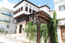
Most of the city's Ottoman wooden buildings have been replaced by concrete apartment blocks, but some are being restored or replaced with attractive houses in the traditional style. Except for the Rüstem Paşa Camii, built by the Ottoman architect, Mimar Sinan, in the 16th century, and the narrow streets that help one imagine life in the Ottoman period, the city lacks antique charm. One reason to visit is the local delicacy, the small spicy cylindrical grilled meatballs called Tekirdağ köftesi, traditionally followed by courses of a sweet local cheese and semolina pudding.
The inland areas are fertile farmland, growing crops including winter wheat, sunflowers, cherries and grapes for wine-making: thus the high quality rakı for which Tekirdağ is noted. The distilleries were state-owned until the 1990s but are now in private hands and the wine and rakı industries are undergoing a renewal. Local red wines are inexpensive and worth a taste.
Both the east-west highway (the Via Egnatia from Roman times) and the highway north toward Muratlı and Lüleburgaz are four lanes. There is a prison next to the rakı distillery and another north of the city on the road to Muratlı.
Tekirdağ is the home of Namık Kemal University, which was founded in 2006 with three faculties. It is located at the eastern edge of the city.
Places of interest
.JPG)
- The Tekirdağ Museum of Archaeology and Ethnography contains archaeological artifacts found in and around the province, as well as ethnographical items used by the residents of the region relating to the history of cultural life.
- The Namık Kemal House Museum is devoted to the life and works of theTurkish nationalist poet Namık Kemal (1840–1888).
- The Rakoczi Museum, an 18th-century Turkish house, where the Hungarian national hero, Francis II Rákóczi lived during his exile, from 1720 till his death in 1735. Today, the museum is a property of the Hungary and is widely visited, having become a place of national pilgrimage.
- The church of Panagia (Virgin Mary) Rheumatocratissa contains the graves, with long Latin inscriptions, of other Hungarians who took refuge here with their leader.
- Of all the statues of Atatürk in Turkey, the town centre of Tekirdağ holds the only one that was made exactly life-size.
Notable people
- Phaedimus of Bisanthe, ancient Greek poet (3rd or 2nd century BC)
- Namık Kemal (1840–1888), Turkish nationalist poet
- Francis II Rákóczi (1676–1735), Hungarian prince and national hero
- Bekri Mustafa Pasha, Ottoman Grand Vizier (1688–1698)
- Tekirdağlı Hüseyin Pehlivan, Yağlı Güreş champion
- Cezayirli Gazi Hasan Pasha
- Khachadour Paul Garabedian, Armenian American United States Navy officer during the American Civil War
- Barsegh Kanachyan, Armenian composer and musicologist
- Henri (Malakian) Verneuil, French-Armenian playwright and filmmaker
- Ardashes Harutunian, Armenian poet, a self-educated translator from French and literary critic
- Rifat Karlova, Turkish comedian and actor (b. 1980) residing in Taiwan.
International relations
Twin towns — Sister cities
|
Namesakes
- Tekirdağ Province, which contains Tekirdağ
- TC-JGE, a Turkish Airlines Boeing 737-800 which crashed as Flight 1951 on 25 February 2009[11]
See also
| Wikimedia Commons has media related to Tekirdağ. |
- Tsar Kaloyan of Bulgaria, destroyer of Rodosto in 1206.
References
- Notes
- ↑ "Area of regions (including lakes), km²". Regional Statistics Database. Turkish Statistical Institute. 2002. Retrieved 2013-03-05.
- ↑ "Population of province/district centers and towns/villages by districts - 2012". Address Based Population Registration System (ABPRS) Database. Turkish Statistical Institute. Retrieved 2013-02-27.
- ↑ http://report.tuik.gov.tr/reports/rwservlet?adnksdb2=&report=idari_yapi_09sonrasi.RDF&p_il1=59&p_yil=2009&p_dil=1&desformat=html&ENVID=nufus2000db2Env
- ↑ Playfair James A System of Geography, ancient and modern, Edinburgh, 1812 vol.4, p.547.
- ↑ Xenophon, Hellenica, BOOKS I, II, English translation. Clarendon Press, 1888.
- ↑ http://www.dmi.gov.tr/veridegerlendirme/il-ve-ilceler-istatistik.aspx?m=TEKIRDAG
- ↑ "History of Tekirdağ". Archived from the original on 6 February 2007. Retrieved 22 March 2007.
- ↑ Volume V23, Page 448 of the 1911 Encyclopædia Britannica. http://en.wikisource.org/w/index.php?title=User:Tim_Starling/ScanSet_TIFF_demo&vol=23&page=ED3A470
- ↑ "Tekirdağ Municipality Web Site - Partner Cities".
 (in Turkish) accessdate=2009-06-17.
 - ↑ 10.0 10.1 10.2 10.3 Negotiations in progress
- ↑ "Accident Information Page". Turkish Airlines. Retrieved 26 February 2009.
External links
 Tekirdağ travel guide from Wikivoyage
- City Website
- Tekirdağ photo gallery

Gallery
-

As mother goddess shaped pot (Tekirdağ Museum of Archaeology and Ethnography)
-

Thracian King Cersobleptes (Tekirdağ Museum of Archaeology and Ethnography)
-

Amphoras (Tekirdağ Museum of Archaeology and Ethnography)
-

Orta Mosque (1855)
-

Bedesten (Ottoman Bazaar)
-

Province government House
-

Tekirdağ Köfte, a local speciality meatballs