Tecuamburro
| Tecuamburro | |
|---|---|
 Volcán Tecuamburro | |
| Elevation | 1,845 m (6,053 ft) |
| Location | |
 Tecuamburro Guatemala | |
| Location | Santa Rosa, Guatemala |
| Coordinates | 14°9′21″N 90°24′25″W / 14.15583°N 90.40694°WCoordinates: 14°9′21″N 90°24′25″W / 14.15583°N 90.40694°W |
| Geology | |
| Type | Stratovolcano |
| Last eruption | 960 BCE ± 75 years |
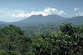
Tecuamburro is a stratovolcano in southern Guatemala, roughly 50 kilometres south east of Guatemala City. The Tecuamburro is an andesitic stratovolcano which formed approximately 38,000 years ago inside a horseshoe-shaped caldera formed by a structural failure in a second, 100,000-year-old stratovolcano, known as Miraflores. At the top of the Tecuamburro is an acidic crater lake around which many hot springs, fumaroles, and boiling mudpots are found.
See also
References
| |||||||||||||||||||||||||||||