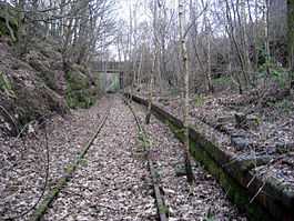
Tean railway station
| Tean | |
|---|---|
|
The remains of Tean railway station, December 2008 | |
| Location | |
| Place | Totmonslow, Staffordshire |
| Area | Staffordshire Moorlands |
| Grid reference | SJ994397 |
| Operations | |
| Pre-grouping | North Staffordshire Railway |
| Post-grouping |
London, Midland and Scottish Railway London Midland Region of British Railways |
| Platforms | 1 |
| History | |
| 7 November 1892 | Opened as Totmonslow |
| December 1906 | Renamed to Tean |
| 1 June 1953 | Closed |
| Disused railway stations in the United Kingdom | |
|
Closed railway stations in Britain A B C D–F G H–J K–L M–O P–R S T–V W–Z | |
| UK Railways portal | |
Tean railway station was a railway station located on the Cheadle Branch Line at Totmonslow, Staffordshire. It was opened as Totmonslow in 1892 and was the terminus of the line until it reached Cheadle in 1901.[1]
Facilities
The station was located in a cutting underneath the Stoke to Uttoxeter turnpike road and had a small goods siding with shed. Because of the restricted location, a loop was provided a short distance to the south, although it was never actually used a such and was removed in 1938.[1]
A platform shelter was the only building until 1907, when part of the station building from Keele Park railway station was erected, the latter having closed earlier that year. Up until this point, a nearby cottage was used as a booking office.[1]
Later years
The station was renamed in 1906 after the village of Upper Tean, which was located around a mile east of Totmonslow. It was never well used and closed in 1953, having by then been reduced to a halt. The goods siding was soon removed and the station site occupied by a scrap merchant until 1977.[1]
| Preceding station | Disused railways | Following station | ||
|---|---|---|---|---|
Line and station closed | North Staffordshire Railway | Line and station closed |
The site today
The track was removed in 2013. The platform remains, although overgrown, and can be seen from the adjacent road bridge. [2]
References
- ↑ 1.0 1.1 1.2 1.3 Baker, Allan C. (1979). The Cheadle Railway. The Oakwood Press. ISBN 085361248X.
- ↑ Ballantyne, Hugh (2005). British Railways Past & Present: North Staffordshire and the Trent Valley. Past & Present Publishing Ltd. ISBN 1858952042.
Coordinates: 52°57′16″N 2°00′33″W / 52.9545°N 2.0093°W
