Tayum, Abra
| Tayum | |
|---|---|
| Municipality | |
 Map of Abra showing the location of Tayum | |
.svg.png) Tayum Location within the Philippines | |
| Coordinates: 17°37′N 120°39′E / 17.617°N 120.650°ECoordinates: 17°37′N 120°39′E / 17.617°N 120.650°E | |
| Country | Philippines |
| Region | Cordillera Administrative Region (CAR) |
| Province | Abra |
| District | Lone District of Abra |
| Barangays | 11 |
| Government[1] | |
| • Mayor | Placido "Glen" P. Eduarte Jr. |
| Area[2] | |
| • Total | 61.14 km2 (23.61 sq mi) |
| Population (2010)[3] | |
| • Total | 13,940 |
| • Density | 230/km2 (590/sq mi) |
| Time zone | PST (UTC+8) |
| ZIP code | 2803 |
| Dialing code | 74 |
| Income class | 5th class municipality |
Tayum is a fifth class municipality in the province of Abra, Philippines.[2] According to the 2010 census, it has a population of 13,940 people.[3] Tayum is just 7 kilometres (4.3 mi) east of capital Bangued. Roman Catholicism is the dominant religion, however, other Christian and other believers also practice in this town. On the 25th of November, Tayum celebrates its town fiesta.
Barangays
Tayum is politically subdivided into 11 barangays.[2]
| Barangay | Population (2007) |
Population (2010)[3] |
|---|---|---|
| Bagalay | |
|
| Basbasa | |
|
| Budac | |
|
| Bumagcat | |
|
| Cabaroan | |
|
| Deet | |
|
| Gaddani | |
|
| Patucannay | |
|
| Pias | |
|
| Poblacion | |
|
| Velasco | |
|
History
Records show that Tayum got its name after the indigo plant which was commonly known to the Ilocanos as Tayum-Tayum. There was a time when indigo flourished in Tayum, then a source of wealth to the Ilocanos. In Barangays Deet, a half kilometer away from the town proper, there was a big vat (Pagtimbugan) used in decaying the plant into a blue-black dye called “ngila”. The dye was used to color yams of cotton. At the beginning of the century, however, a powder dye from the Aniline Factories of Germany came into popular use among Ilocano weavers, causing the death of the indigo industry.
The earliest historical accounts of Tayum date back to 1626 when one adventurous priest, Father Juan Pareja, organized Tayum, also known as Bukaw. Sometime in 1569, another equally daring and adventurous Augustinian Priest, Father Gabriel Alvarez, constructed a temporary chapel in Tayum during the time of his expedition to Lepanto. It was however in 1725 when Tayum was formally organized as a political unit under the Spanish Regime. Don Vidal Banganan served as the first Gobernadorcillo.
From a mere “visita” of Bangued, Tayum metamorphosed into an independent mission in the year 1807 with the construction of the solid brick-walled church under the successive Augustinian missions. The church was dedicated to St. Catherine of Alexandria whose feastday is celebrated every 25th day of November. In 1904, Tayum reverted to a barrio of Bangued, due to the deterioration of peace and order at the time. Tayum ended as a barrio on December 31, 1907, with the designation of Don Pio Balmaceda y Belmonte as Teniente del barrio. Balmaceda organized his men in effectively curbing lawlessness thus restoring the town’s peacefulness. Shortly afterwards, it regained its town status with Don Manuel Brillantes as it first president.
List of Cultural Properties of Tayum
| Cultural Property wmph identifier |
Site name | Description | Province | City/Municipality | Address/Location | Coordinates | Image |
|---|---|---|---|---|---|---|---|
| Saint Catherine of Alexandria Church | A 19th-century Baroque church, declared a National Cultural Treasure by the National Museum of the Philippines in 2001.[4] | Abra | Tayum, Abra | Brgy. Poblacion, Tayum | 17°37′07″N 120°39′16″E / 17.618511°N 120.654319°E | 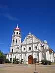 | |
| First SVD Regional House | Established by Fr. Luis Beckert in 1912. Fr. Beckert is the first regional superior of the SVD Missionaries in Abra. | Abra | Tayum, Abra | 17°37′07″N 120°39′16″E / 17.618511°N 120.654319°E | 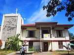 | ||
| Flores Ancestral House | Built in 1890. | Abra | Tayum, Abra | Isidro Flores St. | 17°37′04″N 120°39′18″E / 17.617696°N 120.655003°E | .JPG) | |
| Jose Cariño Sr. Ancestral House | Abra | Tayum, Abra | 1 Brilliantes corner Jose Cariño | 17°37′00″N 120°39′17″E / 17.616621°N 120.654817°E | 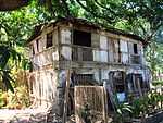 | ||
| Teodoro Brillantes Ancestral House | Abra | Tayum, Abra | Poblacion |  |
Demographics
| Population census of Tayum | ||
|---|---|---|
| Year | Pop. | ±% p.a. |
| 1990 | 11,045 | — |
| 1995 | 12,346 | +2.11% |
| 2000 | 12,539 | +0.33% |
| 2007 | 13,360 | +0.88% |
| 2010 | 13,940 | +1.56% |
| Source: National Statistics Office[3] | ||
Transportation
The main mode of public transportation are tricycles and jeepneys. Tricycles is a three wheel motorbike that can carry more than five adults and locals preference when it comes to transportation . Jeepney is also good but beware to walk from main road to catch the jeepney. Walking to main road to catch jeepney would save you few pesos, as much cheaper in comparison to tricycle.
See also
References
- ↑ "Official City/Municipal 2013 Election Results". Intramuros, Manila, Philippines: Commission on Elections (COMELEC). 11 September 2013. Retrieved 30 December 2013.
- ↑ 2.0 2.1 2.2 "Province: ABRA". PSGC Interactive. Makati City, Philippines: National Statistical Coordination Board. Retrieved 30 December 2013.
- ↑ 3.0 3.1 3.2 3.3 "Total Population by Province, City, Municipality and Barangay: as of May 1, 2010". 2010 Census of Population and Housing. National Statistics Office. Retrieved 30 December 2013.
- ↑ Alba, Reinerio. "The Restoration of 26 Philippine Churches". National Commission on Culture and the Arts. Retrieved 29 December 2014.
External links
 |
La Paz | |
Dolores | |
| |
Lagangilang | |||
| ||||
| | ||||
| Bangued | |
Bucay |
| ||||||||||||||