Tatenice
| Tatenice | |||
|---|---|---|---|
| Municipality | |||
|
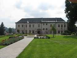
Chateau in Tatenice | |||
| |||
 Tatenice | |||
| Coordinates: 49°52′N 16°41′E / 49.867°N 16.683°ECoordinates: 49°52′N 16°41′E / 49.867°N 16.683°E | |||
| Country |
| ||
| Region | Pardubice | ||
| District | Ústí nad Orlicí | ||
| Area | |||
| • Total | 26.83 km2 (10.36 sq mi) | ||
| Elevation | 344 m (1,129 ft) | ||
| Population (1.1.2013) | |||
| • Total | 845 | ||
| • Density | 31/km2 (82/sq mi) | ||
| Postal code | 561 31 | ||
| Website | http://www.tatenice.cz/ | ||

Tatenice (German: Tattenitz) is a village and municipality (obec) in the Ústí nad Orlicí District, Pardubice Region of the Czech Republic.
The municipality covers an area of 26.83 square kilometres (10.36 sq mi), and had a population of 862 (as of 3 July 2006).
Tatenice lies approximately 25 kilometres (16 mi) south-east of Ústí nad Orlicí, 69 km (43 mi) east of Pardubice, and 165 km (103 mi) east of Prague.
References
| Wikimedia Commons has media related to Tatenice. |