Tatenhill
| Tatenhill | |
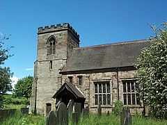 St Michael and All Angels Parish Church |
|
 Tatenhill |
|
| OS grid reference | SK204220 |
|---|---|
| District | East Staffordshire |
| Shire county | Staffordshire |
| Region | West Midlands |
| Country | England |
| Sovereign state | United Kingdom |
| Post town | BURTON-ON-TRENT |
| Postcode district | DE13 |
| Dialling code | 01283 |
| Police | Staffordshire |
| Fire | Staffordshire |
| Ambulance | West Midlands |
| EU Parliament | West Midlands |
| UK Parliament | Burton |
|
|
Coordinates: 52°47′42″N 1°41′56″W / 52.795°N 1.699°W
Tatenhill is an ancient village and a civil parish located in a deep valley, between two hills, which gradually descend from the eastern border of Needwood Forest, 3.5 miles (5.6 km) west-southwest of Burton upon Trent, Staffordshire, England.
Buildings
The sandstone Parish Church of St. Michael is a thirteenth-century building which was substantially enlarged and altered in the 1400s. Around 1890, Bodley restored the church. It is a Grade II* listed building.
Beside the church stands the Old Rectory which was built in the early 1700s (1704 has been found written on the plaster inside the house) for William Binckes, Dean of Lichfield. Noted for its fine Georgian architecture is also a Grade II* listed building. In 2008, this house was one of four finalists in the “England's Finest Parsonage” contest featured in Country Life (magazine).[1]
RAF Tatenhill is an old World War II airfield, still in use for light aircraft as Tatenhill Airfield. On 16 December 2007, there was a light aircraft collision involving an aircraft from Tatenhill.
- ↑ , "England's Finest Parsonage".
External links
| Wikimedia Commons has media related to Tatenhill. |
- GENUKI(tm) page
- Adrian Saravia Rector Of Tatenhill
- The Old Rectory, Tatenhill
- "England's Finest Parsonages—The Finalists" including Tatenhill
- Country Life Picture Library—The Old Rectory, Tatenhill
| ||||||