Tata, Morocco
| Tata ⵜⴰⵜⴰ طاطا | |
|---|---|
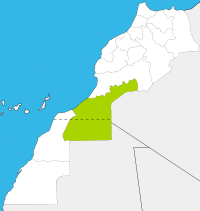
 Tata Location in Morocco | |
| Coordinates: 29°44′34″N 7°58′21″W / 29.74278°N 7.97250°WCoordinates: 29°44′34″N 7°58′21″W / 29.74278°N 7.97250°W | |
| Country |
|
| Region | Guelmim-Es Semara |
| Province | Tata Province |
| Government | |
| • Mayor | Moulay Mahdi El Habibi |
| Population (2004) | |
| • Total | 15,192 |
| Time zone | WET (UTC+0) |
| • Summer (DST) | WEST (UTC+1) |
Tata is a town in south-western Morocco with a population of 15,192 according to the country's 2004 census. It is the largest town in the Tata Province and the fourth largest in the region of Guelmim-Es Semara[1] It is situated on a desert plain of the Sahara Desert, southeast of Agadir and Taroudannt, close to the Algerian border and the mountain range Anti Atlas at the foot of Jebel Bani. Tourists use the town as a base for excursions in the area. Tata lies on the N12 highway between to the north-east of the regional capital Guelmim and to the south of the neighboring region of Souss-Massa-Drâa. It is also near to Algeria, although due to the remoteness of the area there is no border crossing.
References
- Anthony Ham and others (February 2007). Morocco. Lonely Planet. ISBN 978-1-74059-974-0.
| |||||||||||||||||