Tasman National Park
| Tasman National Park Tasmania | |
|---|---|
|
IUCN category II (national park) | |
 Tasman National Park | |
| Nearest town or city | Port Arthur |
| Coordinates | 42°51′19″S 147°58′33″E / 42.85528°S 147.97583°ECoordinates: 42°51′19″S 147°58′33″E / 42.85528°S 147.97583°E |
| Established | 30 April 1999[1] |
| Area | 107.50 km2 (41.5 sq mi)[1] |
| Managing authorities | Tasmania Parks and Wildlife Service |
| Official site | Tasman National Park |
| See also | Protected areas of Tasmania |
Tasman National Park is located in eastern Tasmania, Australia, 56 kilometres east of Hobart.
History
The park was proclaimed under the Regional Forest Agreement on 30 April 1999.[2] The Tasman Island Lighthouse (constructed in 1906) is located on Tasman Island, which is part of the park. This lighthouse and weather station has been unmanned since 1977.[3][4]
Geography
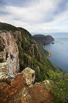
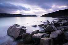
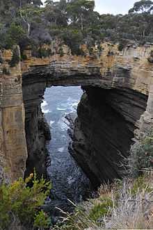
At 300 meters asl, the columnar dolerite cliffs at Cape Pillar and Tasman Island are among the highest in the world.[2] Dolerite is a rare rock type on mainland Australia.[2] Land formations accessible by road include the Blowhole (a hole at the inland end of a sea cave), Devils Kitchen (a rock hole) and Waterfall Bay.[2] Dolerite formations which are more easily viewed from the ocean include Cathedral Rock, Totem Pole, Candlestick, and Tasmans Arch. The park includes The Lanterns, three small islands.
Flora
Three species of Euphrasia (a semi-parasitic, herbaceous flowering plant commonly known as eyebright) are found only in Tasman National Park.[2] The rare Cape Pillar Sheoak is a shrub or small tree found only in the Tasman National Park where it is restricted to the Cape Pillar area of the Tasman Peninsula and to Tasman Island.[5]
Fauna
Australian fur seals use the coastline for breeding and resting, and little penguins (sometimes referred to as "blue penguins" or "fairy penguins") nest along the foreshore.[2]
The park forms part of the South-east Tasmania Important Bird Area, identified as such by BirdLife International because of its importance in the conservation of a range of woodland birds, especially the endangered swift parrot and forty-spotted pardalote.[6]
Three Capes Track
The Three Capes track is a proposed 68 km, 5 night/6 day, hut based, one way walk encompassing the three capes in the Tasman National Park: Cape Hauy, Cape Pillar and Cape Raoul.[7] The proposal would require an additional 30 km of additional walking track, and upgrades to existing track.[7] The proposal suggests that the infrastructure would be required to cater for 60 walkers each day. The feasibility study proposed a fee of $200.[7] The track would start at White Beach and end at Fortesque Bay.[7]
See also
References
| Wikimedia Commons has media related to Tasman National Park. |
- ↑ 1.0 1.1 "Reserve Listing - National Parks". Tasmanian Parks and Wildlife Service Website. Tasmania Parks and Wildlife Service. 17 November 2008. Retrieved 1 May 2010.
- ↑ 2.0 2.1 2.2 2.3 2.4 2.5 "Tasman National Park - Highlights". Parks & Wildlife Service Tasmania. Retrieved 2009-07-23.
- ↑ Brothers, Nigel; Pemberton, David; Pryor, Helen; & Halley, Vanessa. (2001). Tasmania’s Offshore Islands: seabirds and other natural features. Tasmanian Museum and Art Gallery: Hobart. ISBN 0-7246-4816-X
- ↑ "Tasman Island Lighthouse". Lighthouses of Tasmania. Lighthouses of Australia Inc.
- ↑ "Allocasuarina crassa" (PDF). Threatened Flora of Tasmania. Department of Primary Industries and Water, Tasmania. Retrieved 2011-11-03.
- ↑ "IBA: South-east Tasmania". Birdata. Birds Australia. Retrieved 2011-10-13.
- ↑ 7.0 7.1 7.2 7.3 "Three Capes Track Proposal". Department of Environment, Parks, Heritage and the Arts. June 2009. Retrieved 2009-07-23.