Tashir
| Tashir Տաշիր | |
|---|---|
|
The centre of Tashir | |
| Coordinates: 41°07′28″N 44°16′55″E / 41.12444°N 44.28194°E | |
| Country |
|
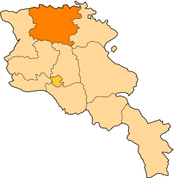
| Marz | Lori |
| Established | 1844 |
| Area | |
| • Total | 5.6 km2 (2.2 sq mi) |
| Elevation | 1,500 m (4,900 ft) |
| Population (2009) | |
| • Total | 8,700 |
| • Density | 1,600/km2 (4,000/sq mi) |

Coordinates: 41°07′28″N 44°16′55″E / 41.12444°N 44.28194°E Tashir (Armenian: Տաշիր), formerly known as Vorontsovka and Kalinino, is a town located in Lori Province of Armenia. It is 42 km north of the provincial centre Vanadzor, in a valley on the road Stepanavan-Tbilisi highway, at a height of 1500 metres above sea level. The population of the town is 8,700. It was previously called Kalinino under the Soviet rule.
History and geography

The town was established in 1844 by Russians who had arrived to the region from the Russian Empire, mainly from the region of Saratov. The newly established settlement was called Vorontsovka after the Viceroy of the Caucasus Mikhail Semyonovich Vorontsov.
In 1935, during the Soviet rule, the settlement was renamed Kalinino after the Russian Bolshevik revolutionary leader Mikhail Kalinin and was called. In 1961, Kalino was granted the statues of a town-settlement. In 1983, it became a town.
With the independence of Armenia in 1991, the town was renamed Tashir after the historic Tashir canton of Gugark, the 13th province of Greater Armenia.
In 1886, the population of Tashir was 2,284. In 1897 it became 3,076. Between 1920 and 1960 the population was around 4,500, a majority of whom were Russians. Until 1989 there were also Azerbaijanis in the town who migrated to Azerbaijan as a result of the Nagorno-Karabakh war.
At an elevation of 1500 metres, Tashir has mild temperatures, with an average temperature of -5 in January and 19 in July. The annual precipitation level is 420 mm. The town is surrounded by black prairies, Alpine meadows and many marshes.
Education and industry
There are 3 high schools (Armenian and Russian), a house of culture, libraries, kindergartens, a sports ground, a sports school, a music school, a dispensary, a hospital, a maternity house, and a knot of communication. The main specialization of the city is industry, and the specific weight occupies food production. Tashir is the site of a Swiss cheese factory, which produces the cheeses Lori and Chanakh. There are also bread, milk and dairy factories. The majority of the inhabitants are employed in agriculture. 32% of the lands are privatized, 71% of which are arable lands and 29% of which are pastures. Half of the state importance lands is 1660 hectare. The lands are also used as arable lands and meadows, which cover 951 and 581 hectares, respectively. Other agricultural products and activities include grain, melons and gourds, potatoes and fruits, cattle-breeding, pig-breeding, poultry farming and bee-keeping. Among the problems of the community are the renewing of school furniture, the reconstruction of intercommunity roads, the reconstruction of sewage system of drinking water, street lighting and reconstruction of monuments.
References
- Tashir at GEOnet Names Server
- World Gazeteer: Armenia – World-Gazetteer.com;
- Report of the results of the 2001 Armenian Census, National Statistical Service of the Republic of Armenia
- - History of Armenia