Tarush Kancha
| Tarush Kancha | |
|---|---|
| Chakchi P'unqu | |
 | |
| Elevation | 5,300 m (17,400 ft)[1] |
| Location | |
 Tarush Kancha Peru | |
| Location | Peru, Ancash Region |
| Range | Andes, Cordillera Blanca |
| Coordinates | 9°15′45″S 77°24′09″W / 9.26250°S 77.40250°WCoordinates: 9°15′45″S 77°24′09″W / 9.26250°S 77.40250°W |
Tarush Kancha (Ancash Quechua taruka, tarush deer, kancha corral,[2] "deer corral", also spelled Tarushcancha) or Chakchi P'unqu (Chaqchipuncu)[3] is a mountain in the Cordillera Blanca in the Andes of Peru, about 5,300 m (17,388 ft) high. It is situated in the Ancash Region, Asunción Province, Chacas District, southeast of Yakuywarmi. Tarush Kancha lies in the Huascarán National Park, at the very end of the Vesubio valley.[1]
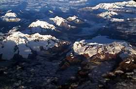
Aerial view of the Cordillera Blanca as seen from the east with Tarush Kancha in the upper right part of the image
References
- ↑ 1.0 1.1 escale.minedu.gob.pe - UGEL map of the Asunción Province (Ancash Region)
- ↑ Robert Beér, Armando Muyolemaj, Dr. Hernán S. Aguilarpaj, Vocabulario comparativo, quechua ecuatoriano - quechua ancashino - castellano - English, Brighton 2006
- ↑ huaraz.com Map of the area
External links
| Wikimedia Commons has media related to Cordillera Blanca. |