Tarmuwa
| Tarmuwa Ta Mai Hamza Gidan kowa | |
|---|---|
| LGA | |
| Motto: Jabbama | |
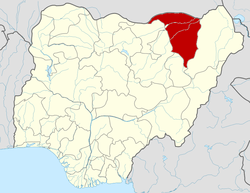
 Tarmuwa Location in Nigeria | |
| Coordinates: 12°12′N 11°47′E / 12.200°N 11.783°ECoordinates: 12°12′N 11°47′E / 12.200°N 11.783°E | |
| Country |
|
| State | Yobe State |
| Mashio kingdom | 1724 |
| Government | |
| • Type | Democracy |
| • Emir | Hrh Mai Hamza Mai Buba Ibn Isa Mashio |
| Area | |
| • Total | 4,594 km2 (1,774 sq mi) |
| Population (2006 census) | |
| • Total | 177,204 |
| Time zone | WAT (UTC+1) |
| 3-digit postal code prefix | 620 |
| ISO 3166 code | NG.YO.TA |
| TYNG | |
Tarmuwa is a Local Government Area in Yobe State, Nigeria. Its headquarters are in the town of Babangida at12°06′27″N 11°45′14″E / 12.10750°N 11.75389°E.
It has an area of 4,594 km² and a population of 177,204 at the 2006 census.
The postal code of the area is 620.[1]
Tarmuwa Town Is Under the leadership of Mashio Kingdom By Jajere Emirate Administration. And Jajere Emirate Is Situated In The Heart Of Yobe State, It Is Surrounded To The North By Bursari Local Gov't, Jakusko Local Gov't To The North West And Damaturu Local Gov't The State Capital. To South Potiskum And Nangere Local Gov't Area To West. It In Pertinent To Note That As A Result Of Yearning Of The People Of The Area . Jajere Emirate Was Created In 1992 By The Civilian Administration Of Governor Bukar Abba Ibrahim(FNIQS). The Headquarters Was Located At Jajere Town But Was Later Dissolved By The Military Administration Compol Dabo Aliyu in 1993. On 6th January , 2000 With The Return Of Civilian Administration Under The Dynamic Leadership Of Governor Bukar Abba Ibrahim Recreated The Present Jajere Emirate comprising: Jajere,Mashio,Zogoto,Muri, Koriyel,Mafa, Sungul and Koka District with Headquarters at Babban gida.
The Members Of The Emirate Consist Of Twenty Tittle Holders Including The Emir. The Present Jajere Emirate Council Was Installed As Second Class Status In 1993 but Later It Was Elevated To First Class Status In 2005 By The State Governor Bukar Abba .The Present Emir Succeeded in his late Father As 2nd Emir In 2001. He Is A Recipient Of Many Awards And Honour both National And International.
References
- ↑ "Post Offices- with map of LGA". NIPOST. Retrieved 2009-10-20.
| |||||||||||||
