Tarim Basin
Coordinates: 39°N 83°E / 39°N 83°E
| Tarim Basin | |||||||||||
|
Tarim Basin | |||||||||||
| Chinese name | |||||||||||
|---|---|---|---|---|---|---|---|---|---|---|---|
| Chinese | 塔里木盆地 | ||||||||||
| |||||||||||
| Nanjiang | |||||||||||
| Chinese | 南疆 | ||||||||||
| Literal meaning | Southern Xinjiang | ||||||||||
| |||||||||||
| Uyghur name | |||||||||||
| Uyghur |
تارىم ئويمانلىقى | ||||||||||
| |||||||||||

The Tarim Basin is an endorheic basin in northwest China occupying an area of about 906,500 km2 (350,000 sq mi).[1] Located in China's Xinjiang region, it is sometimes used synonymously to refer the southern half of the province, or Nanjiang (Chinese: 南疆; pinyin: Nánjiāng; literally: "Southern Xinjiang"). Its northern boundary is the Tian Shan mountain range and its southern boundary is the Kunlun Mountains on the edge of the Qinghai-Tibet Plateau. The Taklamakan Desert dominates much of the basin. The historical Uyghur name for the Tarim Basin is Altishahr (六域), which means "six cities" in Uyghur.
Geography and relation to Xinjiang

Xinjiang consists of two main geographically, historically, and ethnically distinct regions with different historical names, Dzungaria and the Tarim Basin (Altishahr), before Qing China unified them into one political entity called Xinjiang province in 1884. At the time of the Qing conquest in 1759, Dzungaria was inhabited by steppe dwelling, nomadic Tibetan Buddhist Dzungar people, while the Tarim Basin (Altishahr) was inhabited by sedentary, oasis dwelling, Turkic speaking Muslim farmers, now known as the Uyghur people. They were governed separately until 1884.
Geology

The Tarim Basin is the result of an amalgamation between an ancient microcontinent and the growing Eurasian continent during the Carboniferous to Permian periods. At present, deformation around the margins of the basin is resulting in the microcontinental crust being pushed under Tian Shan to the north, and Kunlun Shan to the south.
A thick succession of Paleozoic, Mesozoic and Cenozoic sedimentary rocks occupy the central parts of the basin, locally exceeding thicknesses of 15 km (9 mi). The source rocks of oil and gas tend to be Permian mudstones. Below this level is a complex Precambrian basement believed to be made up of the remnants of the original Tarim microplate, which accrued to the growing Eurasian continent in Carboniferous time. The snow on K2, the second highest mountain in the world, flows into glaciers which move down the valleys to melt. The melted water forms rivers which flow down the mountains and into the Tarim Basin, never reaching the sea. Surrounded by desert, some rivers feed the oases where the water is used for irrigation while others flow to salt lakes and marshes.

Lop Nur is a marshy, saline depression at the east end of the Tarim Basin. The Tarim River ends in Lop Nur.
The Tarim Basin is believed to contain large potential reserves of petroleum and natural gas.[2]:493 Methane comprises over 70 percent of the natural gas reserve, with variable contents of ethane (<1% ~18%) and propane (<0.5% ~9%).[3] China National Petroleum Corporation's comprehensive exploration of the Tarim basin between 1989 and 1995 led to the identification of 26 oil- and gas-bearing structures. These occur at deeper depths and in scattered deposits. Beijing aims to develop Xinjiang into China's new energy base for the long run, supplying one-fifth of the country's total oil supply by 2010, with an annual output of 35 million tonnes.[4] On June 10, 2010 Baker Hughes announced an agreement to work with PetroChina Tarim Oilfield Co. to supply oilfield services, including both directional and vertical drilling systems, formation evaluation services, completion systems and artificial lift technology for wells drilled into foothills formations greater than 7,500 meters (24,600 feet) deep with pressures greater than 20,000 psi (1379 bar) and bottomhole temperatures of approximately 160 °C (320 °F). Electrical submersible pumping (ESP) systems will be employed to dewater gas and condensate wells. PetroChina will fund any joint development.[5]
History

It is speculated that the Tarim Basin may be one of the last places in Asia to have become inhabited: It is surrounded by mountains and irrigation technologies might have been necessary.[6]
The Northern Silk Road on one route bypassed the Tarim Basin north of the Tian Shan mountains and traversed it on three oases-dependent routes: One north of the Taklamakan Desert, one south, and a middle one connecting both through the Lop Nor region.
- The northern Tarim route ran from Kashgar over Aksu, Kucha, Korla, through the Iron Gate Pass, over Karasahr, Jiaohe, Turpan, Gaochang and Kumul to Anxi.
- The southern Tarim route ran from Kashgar over Yarkant, Karghalik, Pishan, Khotan, Keriya, Niya, Qarqan, Qarkilik, Miran and Dunhuang to Anxi.
- The middle Tarim route, allowing the shortest possible itinerary of all four routes, connected Korla on the northern Tarim route over Loulan across the Lop Nor region with Dunhuang on the southern Tarim route. The Lop Nor region became uninhabitable in the 4th century and the middle route has been deserted since the 6th century.
The Tocharian languages were once spoken in the Tarim Basin. They were the easternmost group of Indo-European languages, and may be related to the "Yuezhi" (Chinese 月氏; Wade–Giles: Yüeh-Chih). Besides Tocharian, various Eastern Iranian Khotanese Scythian dialects were also spoken.
Han dynasty
Around 200 BCE, the Yuezhi were overrun by the Xiongnu. The Xiongnu tried to invade the western region of China, but ultimately lost and lost the area to the Chinese. The Han Chinese wrested control of the Tarim Basin from the Xiongnu at the end of the 1st century under the leadership of Gen. Ban Chao (32–102 CE), during the Han-Xiongnu War. The Tarim Basin was later under many foreign rulers, but ruled primary by Turkic, Han, Tibetan, and Mongolic peoples.
The powerful Kushans expanded back into the Tarim Basin in the 1st–2nd centuries CE, where they established a kingdom in Kashgar and competed for control of the area with nomads and Chinese forces. They introduced the Brahmi script, the Indian Prakrit language for administration, and Buddhism, playing a central role in the Silk Road transmission of Buddhism to Eastern Asia.
Lop Nur is the site of the bronze-age Xiaohe Tomb complex from which more than 30 well-preserved mummies have been excavated. It is now a nuclear test site for the People's Republic of China.
Tang dynasty
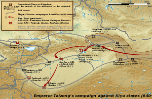
During the Tang Dynasty, a series of military expeditions were conducted against the oasis states of the Tarim Basin, then vassals of the Western Turkic Khaganate.[7] The campaigns against the oasis states began under Emperor Taizong with the annexation of Gaochang in 640.[8] The nearby kingdom of Karasahr was captured by the Tang in 644 and the kingdom of Kucha was conquered in 649.[9]
The expansion into Central Asia continued under Taizong's successor, Emperor Gaozong, who dispatched an army in 657 led by Su Dingfang against the Western Turk qaghan Ashina Helu.[9] Ashina was defeated and the khaganate was absorbed into the Tang empire.[10] The Tarim Basin was administered through the Anxi Protectorate and the Four Garrisons of Anxi. Tang hegemony beyond the Pamir Mountains in modern Tajikistan and Afghanistan ended with revolts by the Turks, but the Tang retained a military presence in Xinjiang. These holdings were later invaded by the Tibetan Empire to the south in 670. For the remainder of the Tang Dynasty, the Tarim Basin alternated between Tang and Tibetan rule as they competed for control of Central Asia.[11]
Qing dynasty

Xinjiang did not exist as one unit until 1884 under Qing rule. It consisted of the two separate political entities of Dzungaria and the Tarim Basin (Eastern Turkestan).[12][13][14][15] Dzungharia or Ili was called Zhunbu 準部 (Dzungar region) Tianshan Beilu 天山北路 (Northern March), "Xinjiang" 新疆 (New Frontier),[16] or "Kalmykia" (La Kalmouquie in French).[17][18] It was formerly the area of the Zunghar Khanate 準噶爾汗國, the land of the Dzungar people. The Tarim Basin was known as "Tianshan Nanlu 天山南路 (southern March), Huibu 回部 (Muslim region), Huijiang 回疆 (Muslim frontier), Chinese Turkestan, Kashgaria, Little Bukharia, East Turkestan", and the traditional Uyghur name for it was Altishahr (Uyghur: التى شهر, ULY: Altä-shähär).[19] It was formerly the area of the Eastern Chagatai Khanate 東察合台汗國, land of the Uyghur people before being conquered by the Dzungars.
Archaeology

Although archaeological findings are of interest in the Tarim Basin, the prime impetus for exploration was petroleum and natural gas. Recent research with help of GIS database have provided a fine-grained analysis of the ancient oasis of Niya on the Silk Road. This research led to significant findings; remains of hamlets with wattle and daub structures as well as farm land, orchards, vineyards, irrigation pools and bridges. The oasis at Niya preserves the ancient landscape. Here also have been found hundreds of 3rd and 4th century wooden accounting tablets at several settlements across the oasis. These texts are in the Kharosthi script native to today's Pakistan and Afghanistan. The texts are legal documents such as tax lists, and contracts containing detailed information pertaining to the administration of daily affairs.[20]
Additional excavations have unearthed tombs with mummies,[21] tools, ceramic works, painted pottery and other artistic artifacts. Such diversity was encouraged by the cultural contacts resulting from this area's position on the Silk Road.[22] Early Buddhist sculptures and murals excavated at Miran show artistic similarities to the traditions of Central Asia and North India[23] and stylistic aspects of paintings found there suggest that Miran had a direct connection with the West, specifically Rome and its provinces.[24]
See also
- Tocharians
- Geography of China
- Silk Road transmission of Buddhism
- Kara-Khanid Khanate
- Kunlun Mountains
- Flaming Mountains
- Taklamakan Desert
- Tarim mummies
- Turpan water system
Notes
- ↑ Encyclopædia Britannica
- ↑ Boliang, H., 1992, Petroleum Geology and Prospects of Tarim (Talimu) Basin, China, In Giant Oil and Gas Fields of the Decade, 1978-1988, AAPG Memoir 54, Halbouty, M.T., editor, Tulsa: American Association of Petroleum Geologists, ISBN0891813330
- ↑ Tongwei Zhang, Quanyou Liu, Jinxing Dai, and Yongchun Tang, "Natural Gas Geochemistry in the Tarim Basin, China and Its Indication to Gas Filling History" (August 20, 2007)
- ↑ Karen Teo, "Doubts over Sinopec oil find in Tarim", The Standard (January 4, 2005)
- ↑ "Baker Hughes Signs Strategic Framework Agreement with PetroChina Tarim Oilfield Co." (June 10, 2010)
- ↑ Wong, Edward (2009-07-12). "Rumbles on the Rim of China’s Empire - NYTimes.com". www.nytimes.com. Retrieved 2009-07-13.
- ↑ Ebrey, Patricia Buckley (2010). The Cambridge Illustrated History of China. Cambridge University Press. p. 111. ISBN 978-0-521-12433-1.
- ↑ Twitchett, Denis; Wechsler, Howard J. (1979). "Kao-tsung (reign 649-83) and the Empress Wu: The Inheritor and the Usurper". In Denis Twitchett; John Fairbank. The Cambridge History of China, Volume 3: Sui and T'ang China Part I. Cambridge University Press. p. 228. ISBN 978-0-521-21446-9.
- ↑ 9.0 9.1 Skaff, Jonathan Karem (2009). Nicola Di Cosmo, ed. Military Culture in Imperial China. Harvard University Press. pp. 183–185. ISBN 978-0-674-03109-8.
- ↑ Skaff, Jonathan Karam (2012). Sui-Tang China and Its Turko-Mongol Neighbors: Culture, Power, and Connections, 580-800. Oxford University Press. p. 190. ISBN 978-0-19-973413-9.
- ↑ Millward, James A. (2007). Eurasian Crossroads: A History of Xinjiang. Columbia University Press. pp. 33–42. ISBN 978-0-231-13924-3.
- ↑ Michell 1870, p. 2.
- ↑ Martin 1847, p. 21.
- ↑ Fisher 1852, p. 554.
- ↑ The Encyclopaedia Britannica: A Dictionary of Arts, Sciences, and General Literature, Volume 23 1852, p. 681.
- ↑ Millward 1998, p. 21.
- ↑ Mentelle, Edme; Brun, Malte 1804, p. 144.
- ↑ Mentelle, Edme; Brun, Malte 1804, p. 160.
- ↑ Millward 1998, p. 23.
- ↑ "Archaeological GIS and Oasis Geography in the Tarim Basin". The Silk Road Foundation Newsletter. Retrieved 2007-07-21.
- ↑ David W. Anthony, Tracking the Tarim Mummies, Archaeology, Volume 54 Number 2, March/April 2001
- ↑ "A Discussion of Sino-Western Cultural Contact and Exchange in the Second Millennium BC Based on Recent Archeological Discoveries". Retrieved 2007-07-21.
- ↑ "Silk Road Trade Routes". University of Washington. Retrieved 2007-08-25.
- ↑ "Ten Centuries of Art on the Silk Road". Retrieved 2007-08-25.
References
- Baumer, Christoph. 2000. Southern Silk Road: In the Footsteps of Sir Aurel Stein and Sven Hedin. White Orchid Books. Bangkok.
- Bellér-Hann, Ildikó (2008). Community Matters in Xinjiang, 1880-1949: Towards a Historical Anthropology of the Uyghur. Brill. ISBN 9004166750.
- Hill, John E. 2004. The Peoples of the West from the Weilue 魏略 by Yu Huan 魚豢: A Third Century Chinese Account Composed between 239 and 265 CE. Draft annotated English translation.
- Hill, John E. (2009) Through the Jade Gate to Rome: A Study of the Silk Routes during the Later Han Dynasty, 1st to 2nd Centuries CE. BookSurge, Charleston, South Carolina. ISBN 978-1-4392-2134-1.
- Mallory, J.P. and Mair, Victor H. 2000. The Tarim Mummies: Ancient China and the Mystery of the Earliest Peoples from the West. Thames & Hudson. London. ISBN 0-500-05101-1
- Malte Conrad Brun (dit Conrad) Malte-Brun; Pierre-Etienne Herbin de Halle (1804). Géographie mathématique, physique & politique de toutes les parties du monde, Volume 12. H. Tardieu. Retrieved 10 March 2014.
|first1=missing|last1=in Authors list (help) - Millward, James A. (1998). Beyond the Pass: Economy, Ethnicity, and Empire in Qing Central Asia, 1759-1864 (illustrated ed.). Stanford University Press. ISBN 0804729336. Retrieved 10 March 2014.
- Stein, Aurel M. 1907. Ancient Khotan: Detailed report of archaeological explorations in Chinese Turkestan, 2 vols. Clarendon Press. Oxford.
- Stein, Aurel M. 1921. Serindia: Detailed report of explorations in Central Asia and westernmost China, 5 vols. London & Oxford. Clarendon Press. Reprint: Delhi. Motilal Banarsidass. 1980.
- Stein Aurel M. 1928. Innermost Asia: Detailed report of explorations in Central Asia, Kan-su and Eastern Iran, 5 vols. Clarendon Press. Reprint: New Delhi. Cosmo Publications. 1981.
External links
| Wikimedia Commons has media related to Tarim Basin. |
- Downloadable article: "Evidence that a West-East admixed population lived in the Tarim Basin as early as the early Bronze Age" Li et al. BMC Biology 2010, 8:15.
- Silk Road Seattle - University of Washington (The Silk Road Seattle website contains many useful resources including a number of full-text historical works)
- The International Dunhuang Project
- Along the ancient silk routes: Central Asian art from the West Berlin State Museums, an exhibition catalog from The Metropolitan Museum of Art (fully available online as PDF), which contains material from the Tarim Basin
| ||||||
| ||||||||||||||||||||||||||||||||||