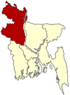
Taraganj Upazila
| Taragonj তারাগঞ্জ | |
|---|---|
| Upazila | |
 Taragonj Location in Bangladesh | |
| Coordinates: 25°48.7′N 89°1′E / 25.8117°N 89.017°ECoordinates: 25°48.7′N 89°1′E / 25.8117°N 89.017°E | |
| Country |
|
| Division | Rangpur Division |
| District | Rangpur District |
| Area | |
| • Total | 128.64 km2 (49.67 sq mi) |
| Population (2011) | |
| • Total | 140,823 |
| • Density | 1,094.7/km2 (2,835/sq mi) |
| Time zone | BST (UTC+6) |
| Website | Official Website of Taragonj |
Taraganj (Bengali: তারাগঞ্জ) is an Upazila of Rangpur District in the Division of Rangpur, Bangladesh.
Geography
Taragonj is located at 25°48′40″N 89°01′00″E / 25.8111°N 89.0167°E . It has 21234 units of house hold and total area 128.64 km².
Demographics
As of the 2011 Bangladesh census, Taraganj has a population of 140823. Males constitute 51.48% of the population, and females 48.52%. This Upazila's eighteen up population is 87803. Taraganj has an average literacy rate of 23.3% (7+ years), and the national average of 32.4% literate.[1]
Administrative
Taraganj has 5 Unions/Wards, 40 Mauzas/Mahallas, and 41 villages.
Unions are: 1. Alampur 2. Kursha 3. Ekarchali 4. Hariarkuti & 5. Soyar
Place of interest
Taragonj Haat is a famous & big in the northern side of Bangladesh and also it is called a business linkage place of Rangpur district. Tara BIBI's mazar is situated in the middle of the Haat. and by the name of TARA BIBI Taragonj was name and it is populated to the people.
In Sadar of Taraganj there is 50 beds hospital, One Degree College, Degree Madrasa, One Boys high school, Girls high school.
Culture
In Taraganj there living all mostly Muslims and Hindus and there also other religion's but they are minor in size. There is no religious issue among the people in Taraganj, every civilians live as people with linked each other.
See also
References
- ↑ "Population Census Wing, BBS.". Archived from the original on 2005-03-27. Retrieved November 10, 2006.
| |||||||||||||||||||||||||||||||||||||||||
