Taplejung Municipality
| Taplejung Municipality ताप्लेजुङ नगरपालिका | |
|---|---|
| Municipality | |
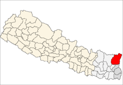
 Taplejung Municipality Location in Nepal | |
| Coordinates: 27°22′N 87°39′E / 27.37°N 87.65°ECoordinates: 27°22′N 87°39′E / 27.37°N 87.65°E | |
| Country |
|
| Zone | Mechi Zone |
| District | Taplejung District |
| Time zone | Nepal Time (UTC+5:45) |
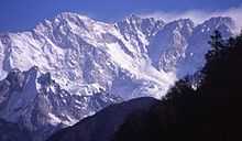
Taplejung is a Municipality in the Himalayas of Taplejung District in the Mechi Zone of north-eastern Nepal. This municipality was formed merging two village development committees i.e. Phungling and Dokhu in May 2014.[1][2] At the time of the 2011 Nepal census it had a population of [Phungling 14974 and Dokhu 4111] 19085 people living in 4480 individual households.
Demography
The main inhabitants of Taplejung are Limbu, Rai, Chhetri, Tamang, Bhramin, Sherpa, Bhote, Newar, Gurung etc.
Transportation
Taplejung Municipality is linked with roadway and airway. It is connected to rest of the country through Mechi Highway, a 262.7 km road which begins in Charali of Mahendra Highway in Jhapa district and ends in Taplejung. Passenger buses and jeeps to Taplejung are easily available in Birtamod. Suketar airport has flight from Biratnagar and Kathmandu.
Media
To Promote local culture Taplejung has Three FM radio station Radio Tamor - 102.0 MHz Which is a Community radio Station, Taplejung F.M. - 94.0 MHz and Radio Faktanglung 89.8 MHz.
References
- ↑ 72 new municipalities announced My Republica
- ↑ Govt announces 72 new municipalities The Kathmandu Post
http://cbs.gov.np/?p=2444 http://cbs.gov.np/wp-content/uploads/2014/04/01%20Taplejung_VDCLevelReport.pdf