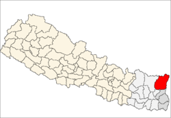
Taplejung District
| Taplejung ताप्लेजुङ | |
|---|---|
| District | |
 | |
| Country | Nepal |
| Region | Eastern (Purwanchal) |
| Zone | Mechi |
| Headquarters | Taplejung |
| Area | |
| • Total | 3,646 km2 (1,408 sq mi) |
| Population (2011[1]) | |
| • Total | 127,461 |
| • Density | 35/km2 (91/sq mi) |
| Time zone | NPT (UTC+5:45) |
Taplejung District (Nepali: ताप्लेजुङ जिल्ला ![]() Listen is the Mountain district of Mechi Zone in Nepal's Eastern Development Region. The district covers 3,646 km2 (1,408 sq mi). The 2011 census counted 127,461 population. Taplejung is the district headquarters
Listen is the Mountain district of Mechi Zone in Nepal's Eastern Development Region. The district covers 3,646 km2 (1,408 sq mi). The 2011 census counted 127,461 population. Taplejung is the district headquarters
The name Taplejung is derived from the words "Taple" and "jung". Taple was the medieval Limbu king who used to rule the area and "jung" in the Limbu language means fort. Literally, Taplejung means Fort of King Taple.
Geography and Climate
| Climate Zone[2] | Elevation Range | % of Area |
|---|---|---|
| Upper Tropical | 300 to 1,000 meters 1,000 to 3,300 ft. |
2.4% |
| Subtropical | 1,000 to 2,000 meters 3,300 to 6,600 ft. |
14.8% |
| Temperate | 2,000 to 3,000 meters 6,400 to 9,800 ft. |
19.5% |
| Subalpine | 3,000 to 4,000 meters 9,800 to 13,100 ft. |
16.8% |
| Alpine | 4,000 to 5,000 meters 13,100 to 16,400 ft. |
38.8% |
| Nival | above 5,000 meters | 7.7% |
Taplejung is in northeastern Nepal. The Tamur River flows through the district. The area is famous for Kanchenjunga the third highest mountain in the world. The district is one of the most beautiful areas in eastern Nepal with spectacular landscapes, Himalayan peaks and a wide range of flora and fauna. Alpine grassland, rocky outcrops, dense temperate and subtropical forests and river valleys make up the region.
Pathibhara Devi Temple
One of the major attractions is the Pathibhara Devi or MUKKUMLUNG (as mentioned in MUNDHUM of kirati people) Temple. This little known region attracts tourists seeking spiritual fulfillment and blessings from the powerful Pathibhara Devi. Hindus and Buddhists visit the temple for celebrations during special occasions. The trek to Pathibhara Devi (3794 m) combined with the natural and cultural experiences of the region make the visit a unique exhilarating experience. It takes a day to reach the temple on foot from Taplejung Bazaar. On the way to the temple one can find many species of rhododendron.
The shrine of the Pathibhara Devi temple is on a mountain at 3794 meters in the east of Nepal. The temple is mostly visited by Hindus on first week of April & September. These days are celebrated as "Dashain". The day devi killed a demon named Maisasur. The shrine of the Pathibhara Devi temple is on a mountain at 3794 meters in the east of Nepal. The temple is holy for Hindus and Buddhists.
The goddesses Pathibhara is said to make dreams come true. The myth is that shepherds suddenly lost a lot of sheep in this area and that Pathibara appeared in their dreams. She promised that the sheep would return if they would offer a few to her. And so they did.
Pathibhara lies in the junction of three VDCs: Tapethok, Limkhim and PhawaKhola VDCs 19 km distance from Taplejung Bazaar (Phungling). The journey to Pathibhara starts from Suketar Airport (2840 m) which is about 1.5 hours walk from Phungling Bazaar. Pathibhara Devi is about 5–6-hour walk from Suketar.
Suketar is only STOL airstrip in Taplejung district and is connected to Kathmandu and Biratnagar by scheduled flights. From Suketar the Pathivara trial passes through Deurali, Ramitedanda, Chhatedhunga, Bhalugaunda, Phedi and finally reaches Pathibhara Devi temple. The trial offers food and lodging facilities. Basic accommodation facilities are also available for pilgrims near the shrine.
The best time to visit is from March to June and September to November.
To reach the Pathibara temple you have to walk for around 10 hours from Suketar. In Suketar is a small airport that can be reached from Kathmandu or Biratnagar.
A good idea is to visit Pathibara Devi temple in combination with the Limbu cultural heritage trekking or on your way to Kanchanjunga base camp.
Village Development Committees (VDCs)


- Ambegudin
- Ankhop
- Chaksibote
- Change
- Dhungesaghu
- Dokhu
- Dummrise
- Ekhabu
- Hangdeva
- Hangpang
- Kalikhola
- Khamlung
- Khejenim
- Khewang
- Khokling
- Lelep
- Limbudin
- Lingtep
- Linkhim
- Liwang
- Mamangkhe
- Nalbu
- Nankholyang
- Nidhuradin
- Olangchung Gola
- Paidang
- Papung
- Pedang
- Phakumba
- Phawakhola
- Phulbari
- Phungling
- Phurumbu
- Sadewa
- Sanghu
- Santhakra
- Sawa
- Sawadin
- Sawalakhu
- Sikaicha
- Sinam
- Surumakhim
- Tapethok
- Tellok
- Thechambu
- Thinglabu
- Thukima
- Thumbedin
- Tiringe
- Yamfudin
- Mehele
Travel
For those wanting to travel Taplejung by road there are two options:
- From Kathmandu to Birtamod (about 500 km, which takes approximately 14 hours), and then from Birtamod to Taplejung Bajar (about 300 km, the road from Birtamod to Phidim, the district headquarters of Panchthar district is a metallic one and from there on, some sections are metallic while others are being black-topped).
- Travel from Kathmandu to Dharan (about 450 km) and from Dhran to Dhankuta, Hiley, Sindha, and Basantapur. After Basantapur travelers have to walk. Walking through the jungle of Gufaa is exciting.
The airport in Suketar (under renovation) can only accommodate aircraft Short Take-off and Landing (STOL).
See also
- Zones of Nepal
- Kanchenjunga
References
- ↑ Household and population by districts, Central Bureau of Statistics (CBS) Nepal
- ↑ The Map of Potential Vegetation of Nepal - a forestry/agroecological/biodiversity classification system, . Forest & Landscape Development and Environment Series 2-2005 and CFC-TIS Document Series No.110., 2005, ISBN 87-7803-210-9, retrieved Nov 22, 2013
