Taplejung
| Taplejung ताप्लेजुङ्ग | |
|---|---|
| Municipality | |
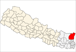
 Taplejung Location in Nepal | |
| Coordinates: 27°21′0″N 87°40′0″E / 27.35000°N 87.66667°ECoordinates: 27°21′0″N 87°40′0″E / 27.35000°N 87.66667°E | |
| Country |
|
| Admin. division | Mechi Zone |
| District | Taplejung District |
| Elevation | 1,441 m (4,730 ft) |
Taplejung a town in Taplejung Municipality is the headquarters of Taplejung District in the Mechi Zone of Nepal. It is located at 27°21'0N 87°40'0E with an altitude of 1441 metres (4730 feet).[1] The name Taplejung is derived from the words "Taple" and "jung". Taple was the medieval Limbu king who used to rule the area and "jung" in Limbu language means fort. Literally, Taplejung means Fort of King Taple.
Geography
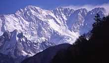
Taplejung is in northeastern Nepal; the Tamur River flows through the district. The area is home of Kangchenjunga (8586 m),the third highest mountain in the world. Taplejung has an airstrip with commercial flights to Biratnagar and Kathmandu. A road connects the district headquarters with the Tarai plains. Most of the population are involved in agriculture, and the vegetation zones range from sub-tropical to temperate forests, alpine meadows, and snow, and ice.
Taplejung is one of the most beautiful areas in eastern Nepal, with a spectacular landscape, Himalayan peaks of heights above 7000 meters and a wide range of flora and fauna. Alpine grassland, rocky outcrops, dense temperate and subtropical forests, and no river valleys make up the region. Taplejung occupies an area ranging from 670 meters to 8586 meters (Mt. Kangchenjunga) above sea level. Kumbhakarna is an outlier of Kangchenjunga.
Offering some of the most spectacular Himalayan landscapes with 13 of the world’s highest mountain peaks rising above 7000 m, Taplejung plays host to the longest blue glacier in the world, the Yalung, and a high biodiversity rate. This area is home to a diverse range of ethnic groups like the Limbus, Tibetans, Sherpas, Rai, Gurung, Magars, Newars and Tamangs. The Kanchenjunga Conservation Area (KCA) in the eastern Himalaya boasts some of the most stunning scenery in all of Nepal. Traditional farming practices are a way of life here. There are rich forests with more than 250 species of bird and animal life. There are a number of high mountain lakes in Olangchung Gola.
The area is made up of alpine grass lands, rocky outcrops, dense temperate and sub-tropical forests, and low river valleys with the Kanchenjunga as its crown and is home to one of the original homelands of the indigenous Limbu people.
Culture
Residents practise integrated early animist religions. Agriculture, animal husbandry and tourism are the major means of livelihood for Limbu people. In the higher altitudes, one can find sherpa people where they arrived from Tibet more than 400 years ago. These sherpas have a distinct culture and tradition from those in Solukhumbu District in the Sagarmatha region. The icons of the cultural heritage are monasteries, chhortens, temples and prayer walls. And to add to the flavour, the festivals of all of these people living in harmony only serve to make the native culture livelier.
Pathibhara Devi Temple
One of the major attractions is the Pathibhara Devi Temple. This little-known region attracts tourists seeking spiritual fulfillment and blessings from the powerful Pathibhara Devi. Hindus and Buddhists reach the temple for celebrations during special occasions. The trek to Pathibhara Devi (3794 m) combined with the natural and cultural experiences of the region make the visit a unique exhilarating experience. It takes a day to reach the temple on foot from Taplejung Bazaar. On the way to the temple are many species of rhododendron.
Notable person
- Chhurim, mountaineer, first woman to climb Everest twice in the same season.
- Te-ongsi Sirijunga Xin Thebe: Limbu martyr and legend.