Taos Plateau volcanic field
Rio Grande Gorge
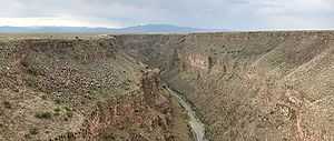
The Taos Plateau volcanic field is an area of extensive volcanism in Taos County, New Mexico, United States. It is the second largest volcanic field in the Rio Grande Rift, spreading over 7,000 km2. The age of most of the vents and associated lava flows in the field is estimated to be between 1.8 and 4 million years, with a few 22 million year old vents. The composition of the lavas varies from tholeiitic basalt to rhyolite. Landforms include sheet flows, cinder cones, and shield volcanoes. The sheet flows are well-exposed in the Rio Grande Gorge carved by the Rio Grande. The highest point of the field is San Antonio Mountain at 10,908 feet (3,325 m).
Notable vents
| Name | Elevation | Location | Last eruption | |
| meters | feet | Coordinates | ||
| San Antonio Mountain | 3,325 | 10,908 | - | |
| Ute Mountain | 3,076 | 10,093 | - | - |
| Cerro de la Olla | 2,887 | 9,475 | - | - |
| Cerro del Aire | 2,750 | 9,045 | - | - |
| Cerro Chiflo | 2,736 | 8,978 | - | - |
| Guadalupe Mountain North | 2,688 | 8,820 | - | - |
| Guadalupe Mountain South | 2,658 | 8,722 | - | - |
| Cerro Montoso | 2,638 | 8,655 | - | - |
References
- Wood, Charles A.; Jürgen Kienle, eds. (1990). Volcanoes of North America. Cambridge University Press. pp. 290–292. ISBN 0-521-43811-X.
- Volcanoes of New Mexico: Taos Plateau Volcanic Field
External links
| Wikimedia Commons has media related to Taos Plateau Volcanic Field. |
Coordinates: 36°50′N 105°50′W / 36.83°N 105.83°W