Tangier-Tetouan
| Tangier-Tetouan طنجة تطوان ⵜⴰⵏⵊⴰ-ⵜⵉⵟⵟⴰⵡⵉⵏ / Tanja-Tiṭṭawin | |
|---|---|
| Region | |
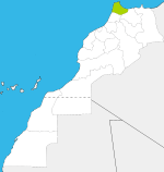
 Location in Morocco | |
| Coordinates: 35°46′N 5°48′W / 35.767°N 5.800°WCoordinates: 35°46′N 5°48′W / 35.767°N 5.800°W | |
| Country |
|
| Capital | Tangier |
| Government | |
| • Wali |
Mohamed Hassad (Tanger-Tétouan) Mohamed Yaakoubi (Tétouan) |
| Area | |
| • Total | 11,570 km2 (4,470 sq mi) |
| Population (2014 census) | |
| • Total | 3,157,075 |
| Time zone | WET (UTC+0) |
| • Summer (DST) | WEST (UTC+1) |
Tangier-Tetouan (Berber: Tanja-Tiṭṭawin, ⵜⴰⵏⵊⴰ-ⵜⵉⵟⵟⴰⵡⵉⵏ; Arabic: طنجة تطوان) is the northernmost of the sixteen regions of Morocco. It covers an area of 11,570 km²[1] and has a population of 3,157,075.[2] The capital is Tangier.
Geography
_-_Air_Photo_by_sebaso.jpg)
Marocco Mediterrane Coast (West Side) - Air Photo form Bades over El Jebha to Tétouan with Rif mountains, Tangier-Tetouan region (2014)
The region has a coastline to the west on the Atlantic Ocean, on the north to the Strait of Gibraltar and to the east on the Mediterranean Sea. It borders the regions of Gharb-Chrarda-Béni Hssen and Taza-Al Hoceima-Taounate to the south and also has a border to the Spanish exclave of Ceuta
The region is made up into the following provinces and prefectures:
- Prefecture of Fahs-Anjra
- Prefecture of Tangier-Assilah
- Prefecture of M'diq-Fnideq
- Chefchaouen Province
- Larache Province
- Ouezzane Province
- Tétouan Province
References
- ↑ Tangier-Tetouan, Morocco.com, accessed 7 February 2013
- ↑ (2014 census)
| ||||||||
| |||||||||||||||||