Tanahun District
| Tanahun तनहुँ | |
|---|---|
| District | |
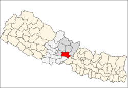 Location of Tanahu | |
| Country | Nepal |
| Region | Western (Pashchimanchal) |
| Zone | Gandaki |
| Established | 1872 |
| Headquarters | Damauli |
| Area | |
| • Total | 1,546 km2 (597 sq mi) |
| Population (2001) | |
| • Total | 315,237 |
| • Density | 200/km2 (530/sq mi) |
| Time zone | NPT (UTC+5:45) |
Tanahun District (Nepali: तनहुँ जिल्ला![]() Listen ), a part of Gandaki Zone, is one of the seventy-five districts of Nepal, a landlocked country of South Asia. The district, with Damauli as its district headquarters, covers an area of 1,546 km² and has a population (2001) of 315,237. Previously the town of Bandipur was its district headquarters. This district lies in the middlemost of country Nepal. The Veda Vyas, or the writer of the holy Mahabharata was born in this district near its headquarters Damauli, at the meeting point of river Seti and Madi. That is why the headquarters is named as Vyas Municipality.
Listen ), a part of Gandaki Zone, is one of the seventy-five districts of Nepal, a landlocked country of South Asia. The district, with Damauli as its district headquarters, covers an area of 1,546 km² and has a population (2001) of 315,237. Previously the town of Bandipur was its district headquarters. This district lies in the middlemost of country Nepal. The Veda Vyas, or the writer of the holy Mahabharata was born in this district near its headquarters Damauli, at the meeting point of river Seti and Madi. That is why the headquarters is named as Vyas Municipality.
Coordinates & Location type
- Latitude: 27.91667
- Longitude:84.25
- Latitude (DMS):27° 55' 0 N
- Longitude (DMS):84° 15' 0 E
Geography and Climate
| Climate Zone[1] | Elevation Range | % of Area |
|---|---|---|
| Lower Tropical | below 300 meters (1,000 ft) | 2.3% |
| Upper Tropical | 300 to 1,000 meters 1,000 to 3,300 ft. |
88.0% |
| Subtropical | 1,000 to 2,000 meters 3,300 to 6,600 ft. |
8.8% |
Village Development Committees (VDCs)
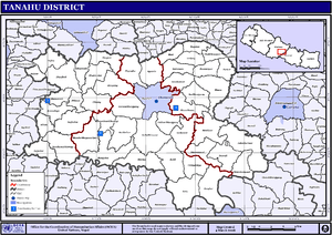
Map of the VDCs in Tanahu District
- Ambukhaireni
- Arunodaya
- Baidi
- Bandipur Municipality
- Barbhanjyang
- Basantapur
- Bhanu
- Bhanumati
- Bhimad
- Bhirkot
- Vyas Municipality
- Chhang
- Chhimkeswori
- Chhipchhipe
- Chok Chisapani
- Deurali
- Devghat
- Dharampani
- Firfire
- Gajarkot
- Ghansikuwa
- Jamune Bhanjyang
- Kabilas
- Kahu Shivapur
- Keshavtar
- Kihun
- Kota
- Kotdarbar
- Kyamin
- Majhakot
- Manpang
- Purkot
- Raipur
- Ramjakot
- Ranipokhari
- Risti
- Rupakot
- Satiswara
- Shuklagandaki Municipality
- Saugatkot, Dhorphirdi
- Sundhara
- Syamgha
- Tanahunsur
- Thaprek
- Mirlung
Map Of Tanahu
http://www.un.org.np/maps/district-maps/western/Tanahu.pdf
See also
- Western Region Campus
- Zones of Nepal
- Bhanubhakta Acharya
- Nara Nath Acharya
References
- ↑ The Map of Potential Vegetation of Nepal - a forestry/agroecological/biodiversity classification system (PDF), . Forest & Landscape Development and Environment Series 2-2005 and CFC-TIS Document Series No.110., 2005, ISBN 87-7803-210-9, retrieved Nov 22, 2013
- Districts of Nepal at statoids.com
Coordinates: 27°55′N 84°15′E / 27.917°N 84.250°E