Tammany Trace
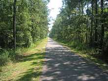
Tammany Trace near Mandeville
The Tammany Trace is a rail trail in Louisiana occupying a former Illinois Central Railroad corridor.
It has been developed into a 31-mile (50 km) asphalt trail for hiking, cycling, and wheelchair use with a parallel equestrian trail.[1]
It connects Covington, Abita Springs, Mandeville, Lacombe, and Slidell running along the northshore of Lake Pontchartrain. The trail was damaged by Hurricane Katrina but was reopened by early 2007.
Location
| Point | Coordinates |
|---|---|
| West end of the trail | 30°28′37″N 90°05′38″W / 30.477°N 90.094°W |
| 59 trailhead/caboose | 30°25′01″N 90°02′38″W / 30.417°N 90.044°W |
| Lafitte Gerard trailhead | 30°21′47″N 90°03′43″W / 30.363°N 90.062°W |
| Lacombe trailhead | 30°18′32″N 89°55′48″W / 30.309°N 89.930°W |
| Slidell/Carollo trailhead | 30°18′04″N 89°49′59″W / 30.301°N 89.833°W |
| East end of the trail | 30°17′49″N 89°46′48″W / 30.297°N 89.780°W |
See also
References
- ↑ "The Trace" (Web). Tammany Trace Foundation. 2007. Retrieved 2007-03-17.
Coordinates: 30°25′01″N 90°02′38″W / 30.417°N 90.044°W