Tamboerskloof
| Tamboerskloof | |
|---|---|
|
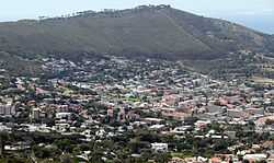
Tamboerskloof seen from Tafelberg Road on Table Mountain | |
 Tamboerskloof
| |
|
Location within Cape Town  Tamboerskloof | |
| Coordinates: 33°55′45″S 18°24′15″E / 33.92917°S 18.40417°ECoordinates: 33°55′45″S 18°24′15″E / 33.92917°S 18.40417°E | |
| Country | South Africa |
| Province | Western Cape |
| Municipality | City of Cape Town |
| Main Place | Cape Town |
| Government | |
| • Councillor | Dave Bryant (DA) |
| Area[1] | |
| • Total | 1.04 km2 (0.40 sq mi) |
| Population (2011)[1] | |
| • Total | 2,984 |
| • Density | 2,900/km2 (7,400/sq mi) |
| Racial makeup (2011)[1] | |
| • Black African | 14.7% |
| • Coloured | 5.1% |
| • Indian/Asian | 1.6% |
| • White | 75.8% |
| • Other | 2.7% |
| First languages (2011)[1] | |
| • English | 62.6% |
| • Afrikaans | 27.6% |
| • Other | 9.9% |
| Postal code (street) | 8001 |
| Area code | 021 |
| Website |
www |

A view of Tamboerskoof
Tamboerskloof is a neighbourhood of Cape Town, South Africa. It lies on the slopes of Lion's Head and Signal Hill, adjacent to the neighbourhoods of Gardens and Bo-Kaap. Tamboerskloof is one neighbourhood within the bouquet of neighbourhoods referred to as the City Bowl.
Schools
Several schools can be found within Tamboerskloof, including Tamboerskloof Primary School, Deutsche Internationale Schule Kapstadt, Jan van Riebeek Primary School and Jan van Riebeek High School.
Demographics
According to the 2001 Census, the population of Tamboerskloof was 2 921. The following tables show various demographic data about Tamboerskloof from that census.[2]
- Gender
| Gender | Population | % |
|---|---|---|
| Female | 1 375 | 52.93% |
| Male | 1 546 | 47.07% |
- Ethnic Group
| Group | Population | % |
|---|---|---|
| Black African | 166 | 5.68% |
| Coloured | 168 | 5.75% |
| Indian/Asian | 27 | 0.92% |
| White | 2 559 | 87.61% |
- Home Language
| Language | Population | % |
|---|---|---|
| English | 1 914 | 65.53% |
| Afrikaans | 693 | 23.72% |
| Xhosa | 58 | 1.99% |
| Other African languages | 35 | 1.20% |
| Other languages | 221 | 7.57% |
References
- ↑ 1.0 1.1 1.2 1.3 "Sub Place Tamboerskloof". Census 2011.
- ↑ "Tamboerskloof". City of Cape Town - Census 2001. City of Cape Town. Retrieved 10 March 2010.
External links
| Wikimedia Commons has media related to Tamboerskloof. |
.svg.png)