Talkha
| Talkha | |
|---|---|
 Talkha Location in Egypt | |
| Coordinates: 31°03′17″N 31°22′32″E / 31.054735°N 31.375644°ECoordinates: 31°03′17″N 31°22′32″E / 31.054735°N 31.375644°E | |
| Country |
|
| Governorate | Dakahlia |
| Elevation | 18 m (59 ft) |
| Population (2012) | |
| • Total | 92,084 |
| Time zone | EST (UTC+2) |
| Postal code | 35111 |
| Area code(s) | 50 |
Talkha (Egyptian Arabic: طلخا pronounced [ˈtˤɑlxɑ]) is a city in Dakahlia Governorate, Egypt.
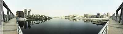
Talkha (right) and Mansoura (left)
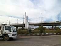
Roads in Talkha
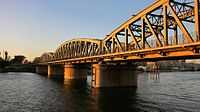
Railway bridge between Talkha and Mansoura
Placed on the west bank of the Damietta branch of the Nile, in the Delta region. Is about 120 km northeast of Cairo. Across from the city, on the opposite east bank of the Nile, is the town of Mansoura that forms agglomeration with Talkha.
Talkha has localities Old Market, El Maalamein, Ar Rouda, El Sharifa, El Muhandisin, Taksim Amru Yunis, Clubs, Fertilizers, Colony, Tunnel.
Climate
See also: Nile Delta
Talkha is classified by Köppen-Geiger climate classification system as hot desert (BWh).
| Climate data for Talkha | |||||||||||||
|---|---|---|---|---|---|---|---|---|---|---|---|---|---|
| Month | Jan | Feb | Mar | Apr | May | Jun | Jul | Aug | Sep | Oct | Nov | Dec | Year |
| Average high °C (°F) | 18.9 (66) |
19.8 (67.6) |
22.4 (72.3) |
26.3 (79.3) |
32 (90) |
33 (91) |
32.7 (90.9) |
33.3 (91.9) |
32 (90) |
27.5 (81.5) |
25 (77) |
20.6 (69.1) |
26.96 (80.55) |
| Daily mean °C (°F) | 12.8 (55) |
13.5 (56.3) |
15.8 (60.4) |
19.1 (66.4) |
23.6 (74.5) |
25.7 (78.3) |
26.7 (80.1) |
26.9 (80.4) |
25.3 (77.5) |
22.8 (73) |
19.4 (66.9) |
14.8 (58.6) |
20.53 (68.95) |
| Average low °C (°F) | 6.8 (44.2) |
7.3 (45.1) |
9.2 (48.6) |
11.9 (53.4) |
15.2 (59.4) |
18.4 (65.1) |
20.7 (69.3) |
20.5 (68.9) |
18.7 (65.7) |
17 (63) |
13.9 (57) |
9.1 (48.4) |
14.06 (57.34) |
| Average precipitation mm (inches) | 13 (0.51) |
9 (0.35) |
6 (0.24) |
4 (0.16) |
3 (0.12) |
0 (0) |
0 (0) |
0 (0) |
0 (0) |
4 (0.16) |
7 (0.28) |
11 (0.43) |
57 (2.25) |
| Source: Climate-Data.org[1] | |||||||||||||
References
- ↑ "Climate: Talkha - Climate graph, Temperature graph, Climate table". Climate-Data.org. Retrieved 13 August 2013.