Talas Region
Coordinates: 42°0′N 72°30′E / 42.000°N 72.500°E
| Talas Province | |||
| Талас областы Таласская область | |||
| Province | |||
|
|||
| Country | Kyrgyzstan | ||
|---|---|---|---|
| Capital | Talas | ||
| Area | 11,400 km2 (4,402 sq mi) | ||
| Population | 219,615 (2009) | ||
| Density | 19 / km2 (49 / sq mi) | ||
| Governor | Koisun Kurmanalieva | ||
| ISO 3166-2 | KG-T | ||
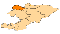 | |||


Talas Province (Kyrgyz: Талас областы) is a province (oblast) of Kyrgyzstan. Its capital is Talas. It is bordered on the west and north by Jambyl Province of Kazakhstan, on the east by Chui Province, on the south by Jalal-Abad Province and on the southwest by a finger of Uzbekistan. It is basically a U-shaped valley open to the west. The northern border is defined by the Kyrgyz Ala-Too, which also form the southern border of Chuy Province. At the eastern end, the Talas Ala-Too Range splits off and marks the southern border. The Talas River flows through the center of the valley. The main highway (A361) enters from the east over the Ötmök Pass (closed in winter) and goes down the valley to Taraz in Kazakhstan. Near the mouth of the valley at Kyzyl-Adyr, one road goes north toward Taraz and the other south over the Kara-Buura Pass to Jalal-Abad Province. Before independence most trade links were with Taraz. The historic Battle of Talas occurred here.
Basic Socio-Economic Indicators
- Employed population: 95,300 (2008) [1]
- Registered Unemployed Population: 2,136 (2008)[2]
- Export: 14.6 million US dollars (2008)[3]
- Import: 193.3 million US dollars (2008) [3]
- Direct Foreign Investments: 30,4 million US dollars (in 2008)[4]
Demographics
As of 2009, Talas Province contained 1 town, 1 urban-type settlement, and 90 villages. Its population, according to the Population and Housing Census of 2009 amounted to 219.6 thousand (enumerated de facto population) or 226.8 thousand (de jure population).[5]
| Historical populations in Talas Province | ||
|---|---|---|
| Year | Pop. | ±% |
| 1970 | 141,169 | — |
| 1979 | 163,288 | +15.7% |
| 1989 | 193,814 | +18.7% |
| 1999 | 200,269 | +3.3% |
| 2009 | 219,615 | +9.7% |
| Note: de jure population; Source:[5] | ||
Ethnic composition
According to the 2009 Census, the ethnic composition of the Talas Province (de jure population) was:[5]
| Ethnic group | Population | Proportion of Talas Province population |
|---|---|---|
| Kyrgyz | 208,399 | 91.9% |
| Kurds | 5,547 | 2.5% |
| Russians | 4,356 | 1.9% |
| Kazakhs | 3,049 | 1.3% |
| Uzbeks | 1,779 | 0.8% |
| Turks | 1,547 | 0.7% |
| Ukrainians | 500 | 0.2% |
| Germans | 384 | 0.2% |
| Tatars | 299 | 0.1% |
| other groups | 919 | 0.4% |
Districts of Talas
Talas province is divided administratively into 4 districts:[6]
| District | Capital |
|---|---|
| Bakay-Ata District | Bakay-Ata[7] |
| Kara-Buura District | Kyzyl-Adyr |
| Manas District | Pokrovka |
| Talas District | Chat Bazar[8] |
References
- ↑ National Committee on Statistics (in Kyrgyz/Russian)
- ↑ National Committee on Statistics (in Kyrgyz/Russian)
- ↑ 3.0 3.1 National Committee on Statistics (in Kyrgyz/Russian)
- ↑ National Committee on Statistics (in Kyrgyz/Russian)
- ↑ 5.0 5.1 5.2 [212.42.101.100:8088/nacstat/sites/default/files/Таласская область.pdf Population and Housing Census 2009. Book 3 (in tables). Provinces of Kyrgyzstan: Talas Province (Перепись населения и жилищного фонда Кыргызской Республики 2009. Книга 3 (в таблицах). Регионы Кыргызстана: Таласская область] (PDF), Bishkek: National Committee on Statistics, 2010
- ↑ Kyrgyzstan - Джалал-Абадская область
- ↑
- ↑
Laurence Mitchell, Kyrgyzstan, Bradt Travel Guides, 2008
External links
 |
Jambyl Province, |
| ||
| |
Chuy Province | |||
| ||||
| | ||||
| Tashkent Province, |
Jalal-Abad Province |