Takuni
| Takuni | |
|---|---|
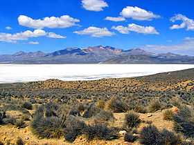 Lake Salinas with Takuni (center) in the background | |
| Elevation | 5,500 m (18,000 ft)[1] |
| Location | |
 Takuni Peru | |
| Location | Peru, Arequipa Region, Arequipa Province, Moquegua Region, General Sanchez Cerro Province |
| Range | Andes |
| Coordinates | 16°28′4″S 71°8′15″W / 16.46778°S 71.13750°WCoordinates: 16°28′4″S 71°8′15″W / 16.46778°S 71.13750°W |
Takuni (Aymara taku Prosopis (genus of South American tree) / colored medicinal earth,[2] -ni a suffix to indicate ownership, "the one with the taku tree" or "the one with medicinal earth", hispanicized spelling Tacune) is a mountain in the Andes of Peru, about 5,500 metres (18,045 ft) high. It is situated south of Lake Salinas and east of the mountain Pikchu Pikchu. Takuni is located in the Arequipa Region, Arequipa Province, Tarucani District, and in the Moquegua Region, General Sánchez Cerro Province, Puquina District.[1]
Takuni is also the name of an intermittent stream which flows from the mountain towards Lake Salinas.[1]
See also
References
- ↑ 1.0 1.1 1.2 escale.minedu.gob.pe - UGEL map of the General Sánchez Cerro (Moquegua Region)
- ↑ Radio San Gabriel, "Instituto Radiofonico de Promoción Aymara" (IRPA) 1993, Republicado por Instituto de las Lenguas y Literaturas Andinas-Amazónicas (ILLLA-A) 2011, Transcripción del Vocabulario de la Lengua Aymara, P. Ludovico Bertonio 1612 (Spanish-Aymara-Aymara-Spanish dictionary)