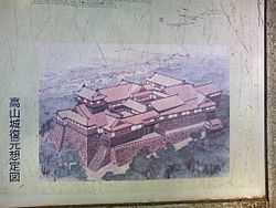
Takayama Castle
| Takayama Castle 高山城 | |
|---|---|
| Takayama, Gifu Prefecture, Japan | |
|
A drawing of the castle | |
| Type | Mountaintop castle |
| Site history | |
| Built | 1588-1600 |
| Built by | Kanamori Nagachika |
| In use | 1588–1695 |
| Demolished | 1695 |
| Garrison information | |
| Occupants | Kanamori clan |
Takayama Castle (高山城 Takayama-jō) is a castle located in the city of Takayama, Gifu Prefecture, Japan. The castle was built on a mountain nearly 687 m (2,254 ft) in height and had many typical castle features, including a stone base, earthen walls and a surrounding moat. In spite of its defensive appearance, however, the castle was not built for battles. Its style is similar to Azuchi Castle, which was built by Oda Nobunaga.
History
During the Sengoku period, Mitsugi Yoritsuna (三木自綱) moved to Takayama to take control of Hida Province and built Matsukura Castle. Yoritsuna was in alliance with Sassa Narimasa in neighboring Etchū Province and was against Toyotomi Hideyoshi. To combat Yoritsuna, Hideyoshi ordered Kanamori Nagachika (who was then the ruler of Echizen Ōno Castle) to go to battle against Yoritsuna.
Nagachika originally began his battle against Yoritsuna using another castle; however, in 1588, he began construction of Takayama Castle.[1] By 1600, the main and secondary castle keeps were completed, but it would be another three years before the third keep was completed. In addition to the construction of the castle, Nagachika also developed a castle town at the same time.
When the Kanamori clan moved to Dewa Province in 1692, they transferred control of the castle to the Maeda clan. Three years later, though, control of the castle was transferred to the Shogun.[1]
The remains of the castle are in the present-day Shiroyama Park.
Castle rulers
- Kanamori Nagachika
- Kanamori Arishige (金森可重)
- Kanamori Shigeyori (金森重頼)
- Kanamori Yorinao (金森頼直)
- Kanamori Yorinari (金森頼業)
- Kanamori Yoritoki (金森頼時)
References
- ↑ 1.0 1.1 Takayama City Sightseeing Information. (Japanese) City of Takayama. Accessed June 12, 2008.
Coordinates: 36°08′17″N 137°15′49″E / 36.138185°N 137.263583°E
