Takahagi, Ibaraki
| Takahagi 高萩市 | ||
|---|---|---|
| City | ||
| ||
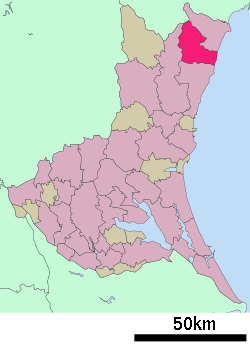 Location of Takahagi in Ibaraki Prefecture | ||
 Takahagi Location in Japan | ||
| Coordinates: 36°43′N 140°43′E / 36.717°N 140.717°ECoordinates: 36°43′N 140°43′E / 36.717°N 140.717°E | ||
| Country | Japan | |
| Region | Kantō | |
| Prefecture | Ibaraki Prefecture | |
| Area | ||
| • Total | 193.65 km2 (74.77 sq mi) | |
| Population (April 1, 2011) | ||
| • Total | 30,367 | |
| • Density | 160/km2 (410/sq mi) | |
| Time zone | Japan Standard Time (UTC+9) | |
| Website | City of Takahagi | |

Takahagi (高萩市 Takahagi-shi) is a city located in Ibaraki Prefecture, Japan. The city was founded on November 23, 1954.
As of April 1, 2011, the city has an estimated population of 30,367, with 11,943 households and a population density 156.81 persons per km². The total area is 193.65 km².
The current mayor is Yoshio Kusama, who was elected in January 2006, and then re-elected for a second term in February 2010.
Symbol of bird is Green Pheasant, symbol of tree is Pinus, and symbol of flower is Lespedeza.
External links
![]() Media related to Takahagi, Ibaraki at Wikimedia Commons
Media related to Takahagi, Ibaraki at Wikimedia Commons
- Takahagi City official website (Japanese)
| ||||||||||||||||||||||||||||||||||||