Tai Tam
| Tai Tam | |||||||||||||||||||
| Traditional Chinese | 大潭 | ||||||||||||||||||
|---|---|---|---|---|---|---|---|---|---|---|---|---|---|---|---|---|---|---|---|
| |||||||||||||||||||

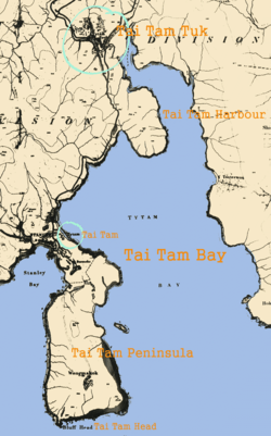
Tai Tam or Tytam is an area in Southern District on Hong Kong Island, Hong Kong. Tai Tam means a big pool in the Chinese language which illustrates a triangular bay, namely Tai Tam Bay between Stanley Peninsula, D'Aguilar Peak and Tai Tam Tuk (大潭篤, lit. innermost of Tai Tam, also known as Tytam Took). The meaning of Tai Tam varies greatly between the early colonial days and present-day.
Current usage
The present-day Tai Tam is the area around Tai Tam Tuk, the location of Tai Tam Tuk Reservoir. It is covered by the Tai Tam Reservoirs, the Tai Tam Country Park and Tai Tam Country Park (Quarry Bay extension). Along Tai Tam Road are some luxurious apartment towers and houses.
The innermost of Tai Tam Bay is Tai Tam Harbour, close to Tai Tam Tuk. The Red Hill Peninsula just south of Tai Tam Road is an area of low-rise luxurious apartments and houses.
Tai Tam Scout Centre is a Scout campsite of The Scout Association of Hong Kong on the shore of Tai Tam Harbour. From the campsite to the foot of the dam of Tai Tam Tuk Reservoir is the Tai Tam Village. The shore outside the village is mudland with some mangrove plants.
The high school and middle school campuses of the Hong Kong International School are also in Tai Tam.
Historical usage
In 1845, Tai Tam was a small habitat east of the market of Stanley, facing Tai Tam Bay. (It still uses the postal address of Tai Tam Village, Stanley). Later, the Stanley Peninsula was also known as Tai Tam Peninsula. The southeast cape of the peninsula is Tai Tam Head. Tai Tam Tuk, the site of Tai Tam Tuk Reservoir, was a valley habitat with extensive cultivation. The village of Tai Tam Tuk was moved to Tai Tam Harbour due to the construction of the reservoir. The Tai Tam area was the scene of heavy fighting between Commonwealth and Japanese forces in December, 1941.
Places in Tai Tam
- American Club Hong Kong has its main, larger location in Tai Tam
- Hong Kong International School
- Hong Kong Parkview
- Red Hill Plaza
- Tai Tam Scout Centre
- Pacific View
- Tai Tam Waterworks Heritage Trail
Coordinates: 22°14′16″N 114°13′25″E / 22.23789°N 114.22368°E