Table Bay
Coordinates: 33°53′S 18°27′E / 33.883°S 18.450°E

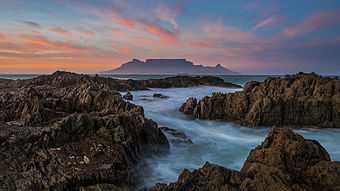
Table Bay (Afrikaans Tafelbaai) is a natural bay on the Atlantic Ocean overlooked by Cape Town (founded 1652 by Van Riebeeck) and is at the northern end of the Cape Peninsula, which stretches south to the Cape of Good Hope. It was named because it is dominated by the flat-topped Table Mountain.
Bartolomeu Dias was the first European to explore this region in 1486. The bay, although famous for centuries as a haven for ships, is actually a rather poor natural harbour and is badly exposed to gales from both the SE and NW. Many sailing ships seeking refuge in the bay during the 17th and 18th centuries were driven ashore by storms (see the article about Wolraad Woltemade).
The Dutch colonists nevertheless persisted with their efforts on the shores of Table Bay, because good natural harbours along this coastline are almost non-existent. The best of them- Saldanha Bay- lacked fresh water and the only realistic alternatives- Simon's Bay and Houtbaai- were rightly inaccessible at the time and only marginally less exposed to the weather, which is notoriously bad often enough in the Cape Peninisula (see article on S.S. Maori and Sea Point). Eventually a harbour was built in Table Bay by a process of land reclamation and was defended by breakwaters to protect shipping. The older part of this structure is called the Victoria Dock. The newer part is called the Duncan Dock.
Robben Island, where Nelson Mandela was imprisoned for decades, is in this bay.
Gallery
-

Dutch ships off Table Bay in the 17th century
-
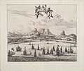
Looking over sailing ships in Table Bay in 1727 with Table Mountain in the background
-
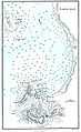
Map of Table Bay (1882)
-
_p0707_TABLE_BAY.jpg)
Map of the Docks and Infrastructure (1884)
-

Cape Town from space, looking south over False Bay with Hangklip Point (top left), Cape Point (top right) and Table Bay south and east of the clearly visible, circular Robben Island, February 1995.
-

Cape Town from space, looking east over Cape Peninsula and False Bay (behind) with Robben Island (front left), Table Mountain (centre front) and Cape Point (front right). The white dot on the left in False Bay is Seal Island, famous for footage of Great White Sharks