Tabarka
| Tabarka | |
|---|---|
 | |
 Tabarka Location in Tunisia | |
| Coordinates: 36°57′16″N 8°45′29″E / 36.95444°N 8.75806°ECoordinates: 36°57′16″N 8°45′29″E / 36.95444°N 8.75806°E | |
| Country |
|
| Governorate | Jendouba Governorate |
| Elevation | 15.4 ft (4,7 m) |
| Population (2014) | |
| • City | 48,993 |
| • Density | 170/sq mi (64/km2) |
| • Urban | 41,025 |
| • Urban density | 3,110/sq mi (1,201/km2) |
| • Ethnicities | Berbers |
| • Religions | Islam |
| Time zone | CET (UTC1) |
| 81.. | 8110 |
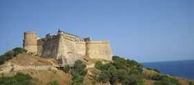
Tabarka (Arabic: طبرقة, Phoenician Tabarka, Thabraca' in Latin,[1][2] Thabarka or Barga by locals) is a coastal town located in north-western Tunisia, at about 36°57′16″N 8°45′29″E / 36.95444°N 8.75806°E, close to the border with Algeria. It has been famous for its coral fishing, the Coral Festival of underwater photography and the annual jazz festival. Tabarka's history is a colorful mosaic of Phoenician, Roman, Arabic and Turkish civilizations. The town is dominated by an offshore rock on which is built a Genoese castle. Nationalist leader Habib Bourguiba, later to become president of post-independence Tunisia, was exiled here by the French colonial authorities in 1952. Itis also considered one of the most rainy towns in Tunisia.
History

Although older sources placed Thabraca within the Roman province of Numidia, recent ones agree in placing it in the Roman province of Africa, known also as Africa Proconsularis.[3][4][5][6] It was a Roman colony. It was connected by a road with Simitthu, to which it served as a port for the exportation of its famous marbles.
At Thabraca the rebellious Roman official Gildo, the brother of Firmus, committed suicide. Under the Vandal king Gaiseric it had a monastery for men and one for women.
Facing it, at a distance of about 365 yards, is the small island of Tabarka, where the Genoese family of the Lomellini, who had purchased the grant of the coral fishing from the Ottoman Turks, maintained a garrison from 1540 to 1742. Here may still be seen the ruins of a stronghold, a church and some Genoese buildings. At Tabarka the ruins consist of a pit once used as a church and some fragments of walls which belonged to Christian buildings. There were also two Ottoman Turkish fortresses, one of which has been repaired.
In 1741 it was surrendered to the (nominally Ottoman, de facto autonomous) Bey of Tunis. Part of the population was moved to the Sardinian island of San Pietro and the town of Calasetta on the adjacent Island of Sant'Antioco, whose population still speaks a variant of Genoese dialect originating from Tabarka. Others were moved to the Spanish island of New Tabarca.[7]
Under French colonial rule it was annexed to the civil district of Souk el-Arba, now in the Tunisian governorate of Jendouba, and a rather important fishing centre.
Ecclesiastical history
Thabraca became a Christian bishopric that, no longer a residential see, is included in the Catholic Church's list of titular sees.[6]
The city contains several Christian cemeteries, many of the tombs covered with curious mosaics. An inscription (C.I.L., VIII, 173-82) mentions the cult of the martyr Anastasia and her companions.
The bishops of Thabraca, who met with the other bishops of Proconsular Africa, included:
- Victoricus, at the Council of Carthage (256);
- Rusticianus, at the conference of Carthage in 411, where his competitor was the Donatist Charentius; he also signed in 416 the letter from the council of Proconsular Africa to Pope Innocent I;
- Clarissimus, who in 646 signed the letter from the same Council to Patriarch Paul II of Constantinople against the Monothelites.
Climate
| Climate data for Tabarka | |||||||||||||
|---|---|---|---|---|---|---|---|---|---|---|---|---|---|
| Month | Jan | Feb | Mar | Apr | May | Jun | Jul | Aug | Sep | Oct | Nov | Dec | Year |
| Record high °C (°F) | 28.6 (83.5) |
29 (84) |
36.6 (97.9) |
37 (99) |
41.3 (106.3) |
47.1 (116.8) |
46.5 (115.7) |
48.3 (118.9) |
43.2 (109.8) |
40 (104) |
30.7 (87.3) |
14.7 (58.5) |
48.3 (118.9) |
| Average high °C (°F) | 15.1 (59.2) |
15.8 (60.4) |
17.9 (64.2) |
20.7 (69.3) |
23.6 (74.5) |
30.3 (86.5) |
30.9 (87.6) |
31.4 (88.5) |
29.7 (85.5) |
25.3 (77.5) |
20.9 (69.6) |
16.3 (61.3) |
23.16 (73.68) |
| Daily mean °C (°F) | 7.4 (45.3) |
11.7 (53.1) |
13.5 (56.3) |
15.5 (59.9) |
18.4 (65.1) |
23 (73) |
25.4 (77.7) |
26 (79) |
24.5 (76.1) |
17.5 (63.5) |
11.1 (52) |
7.1 (44.8) |
16.76 (62.15) |
| Average low °C (°F) | 2.6 (36.7) |
4.6 (40.3) |
9.1 (48.4) |
10.4 (50.7) |
13.3 (55.9) |
17.7 (63.9) |
20 (68) |
20.6 (69.1) |
19.3 (66.7) |
11.7 (53.1) |
7.4 (45.3) |
1.4 (34.5) |
11.51 (52.72) |
| Record low °C (°F) | −5.8 (21.6) |
−5.5 (22.1) |
−0.1 (31.8) |
−0.7 (30.7) |
0 (32) |
9 (48) |
10.1 (50.2) |
11.8 (53.2) |
11 (52) |
−5 (23) |
−4.8 (23.4) |
−8.7 (16.3) |
−8.7 (16.3) |
| Average precipitation mm (inches) | 146 (5.75) |
113 (4.45) |
80 (3.15) |
61 (2.4) |
37 (1.46) |
15 (0.59) |
3 (0.12) |
6 (0.24) |
43 (1.69) |
89 (3.5) |
112 (4.41) |
160 (6.3) |
865 (34.06) |
| Avg. rainy days | 29 | 28 | 12 | 8 | 4 | 2 | 1 | 3 | 5 | 10 | 18 | 29 | 149 |
| Mean monthly sunshine hours | 62.5 | 82.4 | 120.2 | 135.4 | 157.6 | 210.2 | 250.6 | 234.2 | 112.2 | 74.0 | 59.8 | 41.2 | 1,540.3 |
| Source #1: Climate-Data.org,[8] Weather2Travel for rainy days and sunshine[9] | |||||||||||||
| Source #2: Voodoo Skies for record temperatures[10] | |||||||||||||
| Jan | Feb | Mar | Apr | May | Jun | Jul | Aug | Sep | Oct | Nov | Dec |
|---|---|---|---|---|---|---|---|---|---|---|---|
| 15 °C (59 °F) | 15 °C (59 °F) | 15 °C (59 °F) | 15 °C (59 °F) | 17 °C (63 °F) | 21 °C (70 °F) | 24 °C (75 °F) | 25 °C (77 °F) | 24 °C (75 °F) | 22 °C (72 °F) | 19 °C (66 °F) | 16 °C (61 °F) |
Transport
There is one airport in Tabarka that was named Airport 7 Novembre until the Tunisian revolution; it was then renamed Tabarka-Ain Draham International Airport.


See also
- Fossa regia
- Tabarka Rocks
- Genoese-Tabarka diaspora
References
- ↑ Charlton T. Lewis, Charles Short, A Latin Dictionary
- ↑ Victor Chapot, The Roman World (Biblo & Tannen Publishers, 1928 - Rome), p. 385
- ↑ Simon Hornblower, Antony Spawforth, Esther Eidinow (editors), The Oxford Classical Dictionary (Oxford Univeersity Press 2012 ISBN 978-0-19954556-8), entry "Africa, Roman"
- ↑ Jonathan Conant, Staying Roman: Conquest and Identity in Africa and the Mediterranean, 439-700 (Cambridge University Press 2012), p. 48
- ↑ John E. Rotelle (editor), Saint Augustine, Letters 1-99, Part 2, Volume 1 (New City Press 2001 ISBN 978-1-56548163-3), P. 264
- ↑ 6.0 6.1 Annuario Pontificio 2013 (Libreria Editrice Vaticana, 2013, ISBN 978-88-209-9070-1), p. 979
- ↑ Varela, Santiago (1983). "Nueva Tabarca / Nova Tabarca: 1. Generalidades / 1. Generalitats". Alicante / Alacant, Tabarca: Rutas de aproximación al patrimonio cultural valenciano / Rutes d'aproximació al patrimoni cultural valencià (in Spanish and Valencian). Juan Calduch; Joaquín Lara (graphic dessing). Servicio de patrimonio arquitectónico: Conselleria de Cultura, Educación y Ciencia: Generalidad Valenciana.
- ↑ "Climate: Tabarka - Climate graph, Temperature graph, Climate table". Climate-Data.org. Retrieved 21 July 2014.
- ↑ 9.0 9.1 "Tabarka Climate and Weather Averages, Tunisia". Weather2Travel. Retrieved 19 July 2014.
- ↑ "Tabarka, Tuisia". Voodoo Skies. Retrieved 19 July 2014.
External links
 "Thabraca". Catholic Encyclopedia. New York: Robert Appleton Company. 1913.
- Tabarka.Com Tabarka Guide
- Tabarka.Org
- Tabarka Forum
- Tabarka Voyages
- Lexicorient
- WorldStatesmen-Tunisia
![]() This article incorporates text from a publication now in the public domain: Herbermann, Charles, ed. (1913). "Thabraca". Catholic Encyclopedia. Robert Appleton Company.
This article incorporates text from a publication now in the public domain: Herbermann, Charles, ed. (1913). "Thabraca". Catholic Encyclopedia. Robert Appleton Company.
| Wikimedia Commons has media related to Tabarka. |