Ta Phraya National Park
| Ta Phraya National Park | |
|---|---|
| อุทยานแห่งชาติตาพระยา | |
|
IUCN category II (national park) | |
|
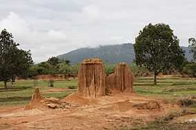
"Lalu" rock formations in the park | |
 Location within Thailand | |
| Location | Buriram and Sakaeo Provinces |
| Nearest city | Sa Kaeo |
| Coordinates | 14°07′N 102°40′E / 14.12°N 102.66°ECoordinates: 14°07′N 102°40′E / 14.12°N 102.66°E |
| Area | 594 km² |
| Established | 1996 |
| Governing body | Royal Forest Department |

Ta Phraya National Park (Thai: อุทยานแห่งชาติตาพระยา) is a protected area at the eastern end of the Sankamphaeng Range in the area where these mountains meet the Dangrek Range, near the Thai-Cambodian border. It is largely in Ta Phraya District, Sa Kaeo Province, district after which it is named, although the park also includes sectors of Ban Kruat, Non Din Daeng, and Lahan Sai Districts of Buriram Province. The park is east of Pang Sida National Park. It was established in 1996.[1]
Elevations range between 206–579 m. The highest mountain is Khao Pran Nut (ยอดเขาพรานนุช).[2] There are lalu (ละลุ, meaning "penetrated" in the Khmer language) natural rock formations caused by erosion, as well as some ancient Khmer temple ruins in the park area such as Prasat Khao Lon.
Between the 1970s and the 1990s there were refugee camps for Cambodians in this part of the border zone.[3]
Ecology
The forested areas of the park include mixed deciduous forest, dry evergreen forest, and deciduous dipterocarp forest.
The fauna of the park includes the Sambar deer, mouse deer, common muntjac, Asian black bear, sun bear, serow, langur, gibbon, palm civet, fishing cat, banteng, gaur and the Siamese hare, as well as the azure-winged magpie, the scarlet minivet, and the long-tailed minivet.
See also
References
External links
| Wikimedia Commons has media related to Ta Phraya National Park. |
| ||||||||||||||||||