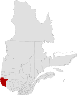
Témiscamingue Regional County Municipality
| Témiscamingue | |
|---|---|
| Regional county municipality | |
 | |
| Coordinates: 47°33′N 79°14′W / 47.550°N 79.233°WCoordinates: 47°33′N 79°14′W / 47.550°N 79.233°W[1] | |
| Country |
|
| Province |
|
| Region | Abitibi-Témiscamingue |
| Effective | April 15, 1981 |
| County seat | Ville-Marie |
| Government[2] | |
| • Type | Prefecture |
| • Prefect | Arnaud Warolin |
| Area[2][3] | |
| • Total | 19,154.10 km2 (7,395.44 sq mi) |
| • Land | 16,419.63 km2 (6,339.65 sq mi) |
| Population (2011)[3] | |
| • Total | 16,425 |
| • Density | 1.0/km2 (3/sq mi) |
| • Pop 2006-2011 |
|
| • Dwellings | 8,494 |
| Time zone | EST (UTC−5) |
| • Summer (DST) | EDT (UTC−4) |
| Area code(s) | 819 |
| Website |
www temiscamingue |
Témiscamingue is a regional county municipality in the Abitibi-Témiscamingue region of western Quebec, Canada. The county seat is Ville-Marie.
Though Témiscamingue borders Pontiac Regional County Municipality to the south, it is not possible to travel between the two within Quebec without taking a major detour north towards Quebec Route 117. The shorter route is to cross into Ontario at Notre-Dame-du-Nord or Témiscaming and travel south on Highway 11, then east on Highway 17, before crossing back at Fort-Coulonge.
Subdivisions
- Cities & Towns (3)
- Belleterre
- Témiscaming
- Ville-Marie
- Municipalities (12)
- Parishes (1)
- Villages (1)
- Townships (2)
- United Townships (1)
- Unorganized Territory (2)
Demographics
Population
| |||||||||||||||||||
| Historical Census Data - Témiscamingue Regional County Municipality, Quebec[6] | ||||||||||||||||||||||||||
|---|---|---|---|---|---|---|---|---|---|---|---|---|---|---|---|---|---|---|---|---|---|---|---|---|---|---|
|
|
| ||||||||||||||||||||||||
Language
| Canada Census Mother Tongue - Témiscamingue Regional County Municipality, Quebec[6] | ||||||||||||||||||
|---|---|---|---|---|---|---|---|---|---|---|---|---|---|---|---|---|---|---|
| Census | Total | French |
English |
French & English |
Other | |||||||||||||
| Year | Responses | Count | Trend | Pop % | Count | Trend | Pop % | Count | Trend | Pop % | Count | Trend | Pop % | |||||
| 2011 |
16,270 |
13,800 | |
84.82% | 2,165 | |
13.31% | 135 | |
0.83% | 170 | |
1.04% | |||||
| 2006 |
16,775 |
14,120 | |
84.17% | 2,170 | |
12.94% | 80 | |
0.48% | 405 | |
2.41% | |||||
| 2001 |
17,285 |
14,795 | |
85.59% | 2,125 | |
12.29% | 130 | |
0.75% | 235 | |
1.36% | |||||
| 1996 |
17,825 |
15,030 | n/a | 84.32% | 2,475 | n/a | 13.88% | 180 | n/a | 1.01% | 140 | n/a | 0.79% | |||||
Transportation
Access Routes
Highways and numbered routes that run through the municipality, including external routes that start or finish at the county border:[7]
|
|
|
See also
References
- ↑ Reference number 141037 of the Commission de toponymie du Québec (French)
- ↑ 2.0 2.1 Geographic code 850 in the official Répertoire des municipalités (French)
- ↑ 3.0 3.1 3.2 "2011 Community Profiles". Canada 2011 Census. Statistics Canada. July 5, 2013. Retrieved 2014-02-23.
- ↑ "2006 Community Profiles". Canada 2006 Census. Statistics Canada. March 30, 2011. Retrieved 2014-02-23.
- ↑ "2001 Community Profiles". Canada 2001 Census. Statistics Canada. February 17, 2012. Retrieved 2014-02-23.
- ↑ 6.0 6.1 Statistics Canada: 1996, 2001, 2006, 2011 census
- ↑ Official Transport Quebec Road Map
 |
|
Rouyn-Noranda TE | La Vallée-de-l'Or RCM | |
| |
||||
| ||||
| | ||||
| |
Pontiac RCM |
| ||||||||||||||