Sysenvatnet
| Sysenvatnet | |
|---|---|
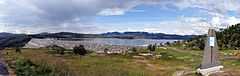 View of the dam at the south end of the lake | |
| Location | Eidfjord, Hordaland |
| Coordinates | 60°25′03″N 7°25′08″E / 60.4176°N 7.4188°ECoordinates: 60°25′03″N 7°25′08″E / 60.4176°N 7.4188°E |
| Basin countries | Norway |
| Max. length | 5.5 kilometres (3.4 mi) |
| Max. width | 3 kilometres (1.9 mi) |
| Surface area | 10.24 km2 (3.95 sq mi) |
| Shore length1 | 17.27 kilometres (10.73 mi) |
| Surface elevation | 940 metres (3,080 ft) |
| References | NVE |
| 1 Shore length is not a well-defined measure. | |
Sysenvatnet is a lake in the municipality of Eidfjord in Hordaland county, Norway. The 10.24-square-kilometre (3.95 sq mi) lake lies at the north end of the Sysendalen valley, about 8 kilometres (5.0 mi) east of the famous Vøringfossen waterfall. The lake is dammed on the south end by a large stone embankment, and the lake is used as the main reservoir for the Sima power station. The dam can be easily seen from the Norwegian National Road 7, which runs near the southern shore of the lake.[1]
See also
- List of lakes in Norway
References
- ↑ Store norske leksikon. "Sysenvatnet" (in Norwegian). Retrieved 2014-05-30.