Symonston, Australian Capital Territory
| Symonston Canberra, Australian Capital Territory | |||||||||||||
|---|---|---|---|---|---|---|---|---|---|---|---|---|---|
 | |||||||||||||
| Population | 648 (2011 census)[1] | ||||||||||||
| • Density | 65.45/km2 (169.53/sq mi) | ||||||||||||
| Established | 1928 | ||||||||||||
| Gazetted | 20 September 1928 | ||||||||||||
| Postcode(s) | 2609 | ||||||||||||
| Area | 9.90 km2 (3.8 sq mi) | ||||||||||||
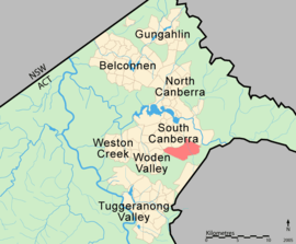
| District | Jerrabomberra | ||||||||||||
| Territory electorate(s) | Molonglo | ||||||||||||
| Federal Division(s) | Canberra | ||||||||||||
| |||||||||||||
Symonston (postcode: 2609) is a primarily industrial and agricultural suburb of Canberra, Australian Capital Territory, Australia. Symonston is named after Sir Josiah Symon a Legislator, Federalist and one of the Founders of the Constitution of Australia.[2]
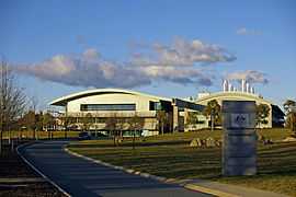
Located in Symonston are the Periodic Detention Centre and Symonston Temporary Remand Centre and three caravan parks: Canberra South Motor Park, Sundown Village and Narrabundah Longstay Caravan Park. Geoscience Australia has its headquarters in Symonston, as does the Therapeutic Goods Administration.
Planning
The Symonston area has traditionally been denoted 'Broadacre' area by the planning authorities, meaning that it has retained a traditionally rural character with some larger institution uses, particularly by the Australian Defence Force and Geoscience Australia. With the release of the Canberra Spatial Plan by the ACT Government, the area and the adjoining Majura Valley has been denoted as an employment corridor centred on Canberra Airport and Fyshwick.
Geology
Rocks in Symonston are from the Silurian age Mount Painter Volcanics dark grey to green grey dacitic tuff underlies most of Symonston. Narrabundah Ashstone Member is found in the northern corner near the motor park. Canberra Formation, calcareous shale found to the east of the ashstone. Further to the east and over to Harman is found the dacitic andesite of the Ainslie Volcanics. An unnamed coarse leucogranite has a small out crop east of Jerrabomberra creek.
Geoscience Australia is the Australian Government organisation tasked with supplying scientific information and knowledge about the geography and geology of Australia. It has information about the geology of the whole of Australia including Canberra.

Coordinates: 35°20′47″S 149°10′40″E / 35.34639°S 149.17778°E
Footnotes
| Wikimedia Commons has media related to Symonston, Australian Capital Territory. |
- ↑ Australian Bureau of Statistics (31 October 2012). "Symonston (State Suburb)". 2011 Census QuickStats. Retrieved 9 February 2014.
- ↑ "Suburb Name search results". ACT Environment and Sustainable Development. Retrieved 9 February 2014.
| ||||||||||