Sylt
Coordinates: 54°54′N 8°20′E / 54.900°N 8.333°E
| Native name: <span class="nickname" ">Söl, Sild | |
|---|---|
 | |
 | |
| Geography | |
| Location | Wadden Sea |
| Coordinates | 54°54′N 8°20′E / 54.900°N 8.333°E |
| Archipelago | North Frisian Islands |
| Major islands | Sylt, Föhr, Amrum |
| Area | 99 km2 (38 sq mi) |
| Length | 38 km (23.6 mi) |
| Width | 13 km (8.1 mi) |
| Highest elevation | 52 m (171 ft) |
| Highest point | Uwe-Düne |
| Country | |
|
Germany | |
| State | Schleswig-Holstein |
| District | Nordfriesland |
| Demographics | |
| Demonym | Sylters |
| Population | 21,000 |
| Density | 212 /km2 (549 /sq mi) |
| Ethnic groups | Germans, Frisians, Danes |
| Additional information | |
| Official website | www.sylt.de |
Sylt (German pronunciation: [ˈzʏlt]; Danish: Sild; Söl'ring North Frisian: Söl) is an island in northern Germany, part of Nordfriesland district, Schleswig-Holstein, and well known for the distinctive shape of its shoreline. It belongs to the North Frisian Islands and is the largest island in North Frisia. The northernmost island of Germany, it is known for its tourist resorts, notably Westerland, Kampen and Wenningstedt-Braderup, as well as for its 40 km long sandy beach. It is frequently covered by the media in connection with its exposed situation in the North Sea and its ongoing loss of land during storm tides. Since 1927, Sylt has been connected to the mainland by the Hindenburgdamm causeway. In latter years, it has been a resort for the German jet set and tourists in search of occasional celebrity sighting.
Geography


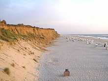
With 99.14 km², Sylt is the fourth-largest German island and the largest German island in the North Sea. Sylt is located from 9 to 16 km off the mainland, to which it is connected by the Hindenburgdamm. Southeast of Sylt are the islands of Föhr and Amrum, to the north lies the Danish island of Rømø. The island of Sylt extends for 38 km in a north-south direction. At its northern peak at Königshafen, it is only 320 m wide. Its greatest width, from the town of Westerland in the west to the eastern Nössespitze near Morsum, measures 12.6 km. On the western and northwestern shore, there is a 40 km sand beach. To the east of Sylt, is the Wadden Sea, which belongs to the Schleswig-Holstein Wadden Sea National Park and mostly falls dry during low tide.
The island's shape has constantly shifted over time, a process which is still ongoing today. The northern and southern spits of Sylt are exclusively made up of infertile sand deposits, while the central part with the municipalities of Westerland, Wenningstedt-Braderup and Sylt-Ost consists of a geestland core, which becomes apparent in the form of the Red Cliff of Wenningstedt. The geestland facing the Wadden Sea gradually turns into fertile marshland around Sylt-Ost. Today sources show that Sylt has only been an island since the Grote Mandrenke flood of 1362.[1] The so-called Uwe-Düne (Uwe Dune) is the island's highest elevation with 52.5 m above sea level.
On Sylt, a marine climate influenced by the Gulf stream is predominant. With an average of 2 °C, winter months are slightly milder than on the mainland, summer months though, with a median of 17 °C, are somewhat cooler, despite a longer sunshine period. The annual average sunshine period on Sylt is 4.4 hours per day. It is due to the low relief of the shoreline that Sylt had a total of 1,899 hours of sunshine in 2005, 180 hours above the German average.[2] Clouds cannot accumulate as quickly and are generally scattered by the constant westerly or northwesterly winds.
The annual mean temperature is 8.5 °C. The annually averaged wind speed measures 6.7 m/s, predominantly from western directions. The annual rainfall amounts to about 650 millimetres.[3] Since 1937 weather data are collected at Deutscher Wetterdienst's northernmost station on a dune near List, which has meanwhile become automated. A number of commercial meteorological services like Meteomedia AG operate stations in List too.
The island in its current form has only existed for about 400 years. Like the mainland geestland, it was formed of moraines from the older ice ages, thus being made up of a till core, which is now apparent in the island's west and centre by the cliff, dunes and beach. This sandy core began to erode as it was exposed to a strong current along the island's steep basement when the sea level rose 8000 years ago. During the process, sediments were accumulated north and south of the island. The west coast, which was originally situated 10 km off today's shore, was thus gradually moved eastward, while at the same time the island began to extend to the north and south. After the ice ages, marshland began to form around this geestland core.
In 1141, Sylt is recorded as an island, yet before the Grote Mandrenke flood it belonged to a landscape cut by tidal creeks and, at least during low tide, it could be reached on foot.[1] It is only since this flood that the creation of a spit from sediments began to form the current characteristic shape of Sylt. It is the northern and southern edges of Sylt which were, and still are, the subject of greatest change. For example, Listland was separated from the rest of the island in the 14th century and from the later 17th century onwards the Königshafen (King's Harbour) began to silt up as the "elbow" spit began to form.[4]
In addition to the constant loss of land, the inhabitants during the Little Ice Age were constrained by sand drift. Dunes shifting to the east threatened settlements and arable land and had to be stopped by the planting of marram grass in the 18th century. Consequently though, material breaking off the island was increasingly washed away and the island's extent continued to decrease.
Records of the annual land loss exist since 1870. According to them, Sylt lost an annual 0.4 m of land in the north and 0.7 m in the south from 1870 to 1951. From 1951 to 1984, the rate increased to 0.9 and 1.4 m respectively, while shorelines at the island's very edges at Hörnum and List are even more affected.[5]
Severe storm surges of the last decades have repeatedly endangered Sylt to the point of breaking in two, e.g. Hörnum was temporarily cut off from the island in 1962. Part of the island near Rantum which is only 500m wide is especially threatened.


Measures of protection against the continuous erosion date back to the early 19th century when groynes of wooden poles were constructed. Those were built at right angles into the sea from the coast line. Later they were replaced by metal and eventually by armoured concrete groynes. The constructions did not have the desired effect of stopping the erosion caused by crossways currents. "Leeward erosion", i.e. erosion on the downwind side of the groynes prevented sustainable accumulation of sand.
In the 1960s breaking the power of the sea was attempted by installing tetrapods along the groyne bases or by putting them into the sea like groynes. The four-armed structures, built in France and many tons in weight were too heavy for Sylt's beaches and were equally unable to prevent erosion. Therefore they were removed from the Hörnum west beach in 2005.[6]
Since the early 1970s the only effective means so far has been flushing sand onto the shore. Dredging vessels are used to pump a mixture of sand and water to a beach where it is spread by bulldozers. Thus storm floods would only erase the artificial accumulation of sand, while the shoreline proper remains intact and erosion is slowed down.[7] This procedure incurs considerable costs. The required budget of an annual €10 million is currently provided by federal German, Schleswig-Holstein state and EU funds. Since 1972 an estimated 35.5 million cubic metres of sand have been flushed ashore and dumped on Sylt. The measures have so far cost more than €134 million in total, but according to scientific calculations they are sufficient to prevent further loss of land for at least three decades, so the benefits for the island's economic power and for the economically underdeveloped region in general would outweigh the costs.[8] In the 1995 study Klimafolgen für Mensch und Küste am Beispiel der Nordseeinsel Sylt (Climate impact for Man and Shores as seen on the North Sea island Sylt) it reads: "Hätte Sylt nicht das Image einer attraktiven Ferieninsel, gäbe es den Küstenschutz in der bestehenden Form gewiss nicht" (If Sylt did not have the image of an attractive holiday island, coastal management in its current form would certainly not exist).[9]
The enforcement of a natural reef off Sylt is being discussed as an alternative solution. A first experiment was conducted from 1996 to 2003.[10] A sand drainage as being successfully used on Danish islands is not likely to work on Sylt owing to the underwater slope here.[11]
In parallel to the ongoing sand flushing, the deliberate demolition of groynes has begun amid great effort at certain beach sections where they were proven largely ineffective. This measure also terminated the presumably most famous groyne of Sylt, Buhne 16 — the namesake of the local naturist beach.
A number of experts, however, fears that Sylt will still have to face considerable losses of land until the mid 21st century. The continuous global warming is thought to result in increasing storm activity, which would result in increased land loss and, as a first impact, might mean the end of property insurance. Measurements showed that, unlike in former times, the wave energy of the sea is no longer lost offshore, today it carries its destructive effects on to the beaches proper. This will result in an annual loss of sand of 1.1 million m³.[4] The dunes of the island constitute nature reserves and may only be traversed on marked tracks. So called "wild paths" promote erosion and are not to be followed. Where vegetation is tread upon, no roots are left to hold the sand and it will be removed by wind and water.
The Wadden Sea on the east side between Sylt and the mainland has been a nature reserve and bird sanctuary since 1935 and is part of the Schleswig-Holstein Wadden Sea National Park. The construction of breakwaters in this area will abate sedimentation and is used for land reclamation.
Also the grazing of sheep on the sea dikes and heaths of Sylt eventually serves coastal management, since the animals keep the vegetation short and compress the soil with their hooves. Thus they help create a denser dike surface, which in case of storm surges provides less area for the waves to impact.
Flora and fauna

The flora of Sylt is shaped by the island's original sparseness. Until the mid 19th century Sylt was an island almost completely devoid of trees, only artificial plantations created small areas of forest and bush. Still today one can recognize the man-made structure of the Friedrichshain and Südwäldchen forests in Westerland, the trees mostly standing in rank and file. Also the now widespread rose Rosa rugosa, known as the "Sylt rose" on the island was only imported to Sylt. It originates from the Kamchatka peninsula in Siberia. The undemanding rose met ideal conditions on Sylt and spread so quickly that it is now a common sight on the island. Its proliferation is viewed critically from a biological point of view, since it threatens to displace endangered local species, especially on the heaths.[12]
The ample heaths on the eastern side of the island provide habitats for many rare species of plants and animals which are adapted to the extreme conditions such as drought, warmth, wind. About 2,500 animal species and 150 species of plants have so far been recorded. 45% of those plants are on the IUCN Red List.[12] Especially notable are the 600 species of butterflies that live in the heaths, small tortoiseshell, brimstone, painted lady and peacock butterfly among them.[13]
With several thousand individuals in the dune belt of Sylt, the natterjack toad, endangered in Germany, has one of Germany's largest populations here. Their spawning places are wet dune slacks and shallow, short-lived pools. For a habitat they prefer sandy areas with vegetation. The main threat for this species on Sylt is road traffic.[14]
The many water birds and other coastal avians, that have their hatching grounds on Sylt or use the island for resting on their migrations constitute an ornithological feature. There are two notable hatching areas on Sylt, the Königshafen bay with the small island Uthörn in the north and the Rantum basin in the southeast. Birds that hatch on Sylt include black-headed gull, Arctic tern, pied avocet, common redshank, common gull, oystercatcher, northern lapwing, common shelduck and tufted duck. During the migration, Sylt is a resting spot for thousands of brent geese and shelducks, Eurasian wigeons and common eiders, as well as bar-tailed godwits, red knots, dunlins and Eurasian golden plovers. Ringed plover, common snipe, ruff and other species are less common visitors to the island.[15]
Regarding land mammals, there is no significant difference from the neighbouring areas of mainland Nordfriesland. Primarily European hare, rabbit and roe deer can be found and are also hunted as game on the island. When the island was connected to the mainland by the causeway fox and badger also became common.
West of Sylt a breeding area of harbour porpoises is located. In addition, great numbers of harbour seals and grey seals, the latter being rather uncommon in German seas, can be found on sand banks off Sylt.
Numerous associations and societies that care for the exploration and the protection of endangered animals and plants have their branches on Sylt. Among them are the Alfred-Wegener-Institute for Polar and Marine Research, Verein Jordsand and Wadden Sea Conservation Station. Also the Federal Office for the Environment operates a research station in the dunes at Westerland.
Climate
Sylt features an oceanic climate that is influenced by the Gulf Stream. On average, the winter season is slightly warmer than in mainland Nordfriesland. The summer season, however, is cooler despite of longer sunshine periods. The yearly average sunshine period is greater than 4.4 hours per day with some years exceeding the average sunshine for all of Germany. Also precipitation is lower than on the mainland. This is due to the low relief of Sylt's shoreline where clouds are not able to accumulate and rain off.[16]
| Climate data for List (1961-1990 averages) | |||||||||||||
|---|---|---|---|---|---|---|---|---|---|---|---|---|---|
| Month | Jan | Feb | Mar | Apr | May | Jun | Jul | Aug | Sep | Oct | Nov | Dec | Year |
| Daily mean °C | 1.0 | 0.9 | 2.7 | 6.0 | 10.8 | 14.2 | 15.7 | 16.2 | 13.9 | 10.4 | 6.1 | 2.8 | 8.39 |
| Average precipitation mm | 57.3 | 35.1 | 44.9 | 39.5 | 41.5 | 55.9 | 62.1 | 72.1 | 82.5 | 88.5 | 94.3 | 71.6 | 745.3 |
| Daily mean °F | 33.8 | 33.6 | 36.9 | 42.8 | 51.4 | 57.6 | 60.3 | 61.2 | 57 | 50.7 | 43 | 37 | 47.11 |
| Average precipitation inches | 2.256 | 1.382 | 1.768 | 1.555 | 1.634 | 2.201 | 2.445 | 2.839 | 3.248 | 3.484 | 3.713 | 2.819 | 29.343 |
| Mean monthly sunshine hours | 46.7 | 75.3 | 120.1 | 179.3 | 243 | 246.5 | 230.7 | 228.1 | 147.8 | 98.3 | 55.6 | 42.6 | 1,714 |
| Source: German Weather Service[17] | |||||||||||||
Settlements

.jpg)
Sylt is divided into two administrative bodies: the Amt Landschaft Sylt with its seat in Keitum administrates all municipalities on the island, save for the independent town of Westerland. As of December 2007, Sylt had 21,190 inhabitants, 9,072 of whom living in Westerland.[18] These numbers do not include owners of summer residences.
A referendum held in May 2008 resulted in a merger of the Sylt-Ost municipality with the town of Westerland due 1 January 2009.[19] Various interest groups hope to merge every island municipality into one governing body.[20]
Settlements along the west coast
Six municipalities are situated along the west coast of Sylt. List in the very north of the island constitutes Germany's northernmost municipality, it retained a certain independence due to its remote location and its long-time adherence to the kingdom of Denmark. On its eastern shore, a harbour is located where, in addition to tourist ships, the "Sylt-Express" ferry-boat sails to Havneby on the Danish island Rømø. Wenningstedt together with Braderup and Kampen used to form the Norddörfer (Northern Villages) municipality, an early intercommunal association, which partly remains today in form of a school union. While Kampen, mainly in the 1950s and 1960s was famous in Germany for attracting celebrities, Wenningstedt is known as a "family resort" for more than 100 years. Since 1855, the prominent black and white Kampen lighthouse is located between Kampen and Wenningstedt, it is the oldest one on the island. East of there, the "Braderuper Heide" nature reserve is situated. Right south of Wenningstedt are the town limits of the island's metropolis, Westerland.
After the complete destruction of the village Eidum by a storm surge on 1 November 1436, the survivors founded a new village northeast of their old home: Westerland. The name was first recorded in 1462. In 1865 a seaside spa was founded, 50 years later Westerland was granted town privileges. In 1949 it was finally officially recognised as a health resort. In 2007, the town counted 9,072 citizens.
South of Westerland, the island extends for about 15 km in the form of a spit, until it is cut by the Hörnumtief tidal creek, that runs through the Wadden Sea mudflats east of Sylt. Here is the location of Rantum. This village, like no other on Sylt, had to fight sand drift during the past centuries. Many farmsteads and a church had to be abandoned because of shifting dunes moving eastward. Only the planting of marram grass stopped the dunes and put an end to this threat. To the east there are a few scattered spots of marshland, while the area is mostly coined by dunes.
Hörnum on the island's southern headland is the youngest village, having been founded shortly after 1900. But already in former times the uninhabited southern tip of Sylt was said to serve as refuge for pirates and fishermen. The name Budersand in the area emanates from that custom, marking a great dune where booths (German: Buden) stood in former times to serve as shelters.[21] This southern headland, called Odde, is marked by continuous loss of land. Each year great amounts of sand are washed away by storm floods and coastal management has not yet seen sustainable effects in the area, so that further losses have to be expected.
Sylt-Ost
Sylt-Ost (East Sylt) is a former municipality which was formed in 1970 out of several small villages on the Nössehalbinsel of Sylt. The population (as of 2000) was 5,500. The villages included Tinnum, Munkmarsch, Archsum, Morsum and Keitum. In 2009, Sylt-Ost merged with Westerland and Rantum to form Gemeinde Sylt.
Transport
Sylt is connected to the German mainland by the Hindenburgdamm, a causeway with a railway line on top. The passenger trains connect Westerland to Niebüll or Klanxbüll, and the Deutsche Bahn's "Syltshuttle" allows the transfer of cars and trucks between Westerland and Niebüll. Furthermore, ferry services to the nearby Danish island of Rømø exist. Sylt Airport at Westerland serves the region.
Culture
Sylt is a part of the Frisian Islands. It has its own local dialect, Söl'ring, which is the indigenous speech of Sylt. Söl'ring is a dialect of insular North Frisian, with elements of Danish, Dutch and English. Today, only a small fraction of the population still speaks Söl'ring. A law to promote the language (Friesisch-Gesetz) was passed in 2004. The northernmost part of the island, Listland, was traditionally Danish-speaking.
As in many areas in Schleswig-Holstein on New Year's Eve, groups of children go masked from house to house, reciting poems. This is known as "Rummelpottlaufen", and as a reward, children receive sweets and/or money.
Sylt also features many Frisian-style houses with thatched roofs.
History
- Sylt was originally part of Jutland (today Schleswig-Holstein and mainland Denmark)
- There is evidence of human habitation going back to 3000 BC at Denghoog
- First settlements of Frisians during the 8th century and 9th century
- Sylt was divided between the Duke of Schleswig and the Kingdom of Denmark in 1386
- Except for the town of List, Sylt became part of the Duchy of Schleswig in 1435
- During the 17th century and 18th century, whaling, fishing and oyster breeding increased the wealth of the population
- Keitum became the capital of the island, and a place for rich captains to settle down
- In the 19th century, tourism began; Westerland replaced Keitum as the capital
- During World War I, Sylt became a military outpost, but did not suffer from war damage
- In 1927, a rail causeway to the mainland was built, the Hindenburgdamm, named after Paul von Hindenburg
- During World War II, Sylt became a fortress, with concrete bunkers built below the dunes at the shore, some of which are still visible today. Lager Sylt, the concentration camp on Alderney was named after the island.
- When Nazi Germany lost the war Rudolf Höss hid on the island, but was later captured and brought to trial in Poland.[22]
Today, Sylt is mainly a tourist attraction, famous for its healthy climate, and the many German celebrities who own houses on the island. The beach even has a nude section.
In other media
The island was used during the filming of The Ghost Writer, as an alternate location for Martha's Vineyard, due to travel restrictions on the film's director, Roman Polanski.
See also
- Üüs Söl’ring Lön’, insular anthem
- Heinz Reinefarth a German military officer during and official after World War II.
- Uthlande
- Victor jagt zwölf Boxkämpfer quer über den großen Sylter Deich "Victor chases twelve boxers across the great dam of Sylt", a German pangram.
References
- ↑ 1.0 1.1 Kehl, H. "Entstehung der Insel Sylt im Laufe von 700 Jahren" (in German). Institute of Ecology, Technical University Berlin.
- ↑ "Tourimusstatistik 2005" (PDF) (in German). Town of Westerland.
- ↑ "List auf Sylt (climate chart)". Bernhard Mühr. 1 June 2007.
- ↑ 4.0 4.1 Thiede, J; K. Ahrendt (2000). "Klimaänderung und Küste – Fallstudie Sylt" (PDF) (in German). GEOMAR, University of Kiel.
- ↑ Landesamt für den Nationalpark Schleswig-Holsteinisches Wattenmeer, Umweltbundesamt, ed. (1998). Umweltatlas Wattenmeer (Wadden Sea environmental Atlas) (in German). I – Nordfriesisches und Dithmarscher Wattenmeer. Stuttgart. p. 38.
- ↑ Witte, J.-O.; Kohlhase, Sören, J. Radomski, P. Fröhle. "Fallstudie Sylt" (PDF) (in German). University of Rostock.
- ↑ Von Liebermann, Nicole. "Küstenschutz: Bisherige und zukünftige Maßnahmen" (PDF) (in German). Technical University of Harburg.
- ↑ Daschkeit, Achim; Horst Sterr. "Küste, Ökologie und Mensch, Integriertes Küstenmanagement als Instrument nachhaltiger Entwicklung". In Bernhard Glaeser. Edition Humanökologie (PDF) 2. Deutsche Gesellschaft für Humanökologie.
- ↑ Daschkeit, Achim; Peter Schottes (2002). Klimafolgen für Mensch und Küste am Beispiel der Nordseeinsel Sylt (in German). Springer. ISBN 978-3-540-42569-4.
- ↑ Bleck, Matthias. "Funktionale Bemessung künstlicher Riffe für aktiven und sanften Küstenschutz" (PDF). Stiftung deutscher Küstenschutz.
- ↑ Newig, J. "Sand auf Sylt" (PDF). University of Kiel.
- ↑ 12.0 12.1 "Interessantes über die Braderuper Heide" (in German). Naturschutzgemeinschaft Sylt.
- ↑ "Morsum-Kliff" (in German). Naturschutzgemeinschaft Sylt.
- ↑ Klinge, Andreas (2003). "Die Amphibien und Reptilien Schleswig-Holsteins, Rote Liste" (PDF). 3rd version (in German). Schleswig-Holstein State Office for Nature and Environment.
- ↑ Lohmann, M.; K. Haarmann. Vogelparadiese (in German). 1 – Norddeutschland. Paul Parey. ISBN 3-490-16418-0.
- ↑ "Das Wetter auf Sylt: viel Sonne und eine frische Brise" [The Weather on Sylt: A lot of Sunshine and a fresh Breeze]. Zeit Reisen (in German). Retrieved 23 October 2012.
- ↑ "Frei zugängliche Klimadaten" (in German). German Weather Service.
- ↑ "Orte, Städte, Gemeinden im Landkreis Nordfriesland" (in German). Deutschland auf einen Blick.
- ↑ "Westerland und Sylt-Ost fusionieren". Sylter Rundschau (in German) (Schleswig-Holsteinischer Zeitungsverlag). 26 May 2008.
- ↑ "Der Fahrplan zur Teilfusion: So geht es jetzt weiter". Sylter Rundschau (in German) (Schleswig-Holsteinischer Zeitungsverlag). 27 May 2008.
- ↑ Pahl, Max (1983). Hörnum. Heimat am Horn – Querschnitt und Streifzüge durch Geschichte, Leben und Landschaft des Nordseebades Hörnum auf Sylt (in German). Lunden: Verlagsdruckerei Schallhorn.
- ↑ "Auschwitz: Inside the Nazi State. Auschwitz 1940-1945. Liberation & Revenge". PBS.
External links
| Wikimedia Commons has media related to Sylt. |
| ||||||||||||||||||||||||||||||||||||||||||||||||||||||||
