Sydenham
| Sydenham | |
 Sydenham Avenue |
|
 Sydenham |
|
| Population | 28,378 (SE26 postcode area)[1] |
|---|---|
| OS grid reference | TQ352714 |
| London borough | Lewisham |
| Bromley | |
| Southwark | |
| Ceremonial county | Greater London |
| Region | London |
| Country | England |
| Sovereign state | United Kingdom |
| Post town | LONDON |
| Postcode district | SE26 |
| Dialling code | 020 |
| Police | Metropolitan |
| Fire | London |
| Ambulance | London |
| EU Parliament | London |
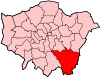
| UK Parliament | Lewisham West and Penge |
| London Assembly | Greenwich and Lewisham |
| Bexley and Bromley | |
| Lambeth and Southwark | |
| Website | http://sydenham.org.uk/ |
Coordinates: 51°25′31″N 0°03′16″W / 51.4254°N 0.0544°W
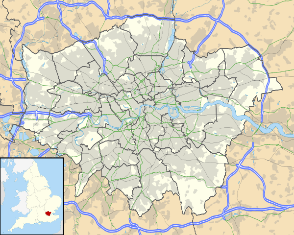
Sydenham (/ˈsɪdnəm/) is a suburban district of south London in the London Boroughs of Lewisham, Bromley and Southwark. Sydenham was located in Kent until 1889 when the County of London was formed, additionally, in 1965 Sydenham became part of the current London Boroughs. The area was one of the first in southern England to have a railway station, opening 1839 by the London and Croydon Railway. Sydenham is the location where the Crystal Palace from the Great Exhibition was relocated in 1854.Today Sydenham is a diverse suburb with a population of 28,378 in 2011[1]
History
Originally known as Shippenham,[2] Sydenham began as a small settlement, a few cottages among the woods, whose inhabitants grazed their animals and collected wood. In the 1640s, springs of water in what is now Wells Park were discovered to have medicinal properties, attracting crowds of people to the area. Sydenham grew rapidly in the 19th century after the introduction of the Croydon Canal in 1809 which linked the Grand Surrey Canal to Croydon and a reservoir was constructed in Sydenham. However, the canal was never successful and closed in 1836[3] resulting in it being the first canal to be abandoned by an Act of Parliament. The London & Croydon Railway purchased the canal for £40,250 and quickly converted the alignment for a railway from London Bridge to West Croydon, opening in 1839. After the railway opened potential gas companies began to consider the Sydenham area with the Crystal Palace and District Gas Company having works at Bell Green, which continued production until 1969; a retail park now occupies most of the site.
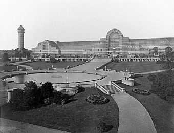
In 1851 the Great Exhibition in Hyde Park was housed in an immense glass building, called the Crystal Palace. In 1854 the building was bought by a private company, dismantled and re-erected in Sydenham Park (now called Crystal Palace Park). Exhibitions, concerts, conferences and sporting events were held at the Crystal Palace (until it burned down in 1936), and Sydenham became a fashionable area; many new houses were built. In 1872, the Children's Hospital, Sydenham opened. It closed in 1991, its services being now part of the University Hospital Lewisham.[4]
A railway station, Upper Sydenham opened in 1884 and closed in 1954, with temporary closings in between. The station opened by the London, Chatham and Dover Railway had direct trains to Crystal Palace and London Victoria.[5] The station and the line were poorly used despite new houses being built in the area, as passengers preferred to use other stations near-by Sydenham Hill (opening in 1863), Crystal Palace (Lower Level) and Sydenham which were on more direct routes. The ill fate of the Crystal Palace in 1936 saw patronage reduced and the route finally closed in 1954.
Sydenham was attacked by enemies during the Second World War. The gas works were a target, but were never damaged. The railway which ran through Upper Sydenham station was damaged, and some homes in the area were destroyed.
Local area
Sydenham is divided into many localities:

Sydenham Hill in the Boroughs of Lewisham and Southwark runs alongside Dulwich and Sydenham Woods on one of the highest points of Greater London being 112 meters above sea level.[6] From here, the City of London skyline is visible. Sydenham Hill has an abandoned railway tunnel from the Crystal Palace and South London Junction Railway located within the Woods. Another railway tunnel (one of the longest in Britain being 1,958 meters) goes beneath on the Chatham Main Line with Sydenham Hill station at the London end serving both Sydenham Hill and the College area of Dulwich.
Upper Sydenham is also located on Sydenham Hill and is a part of the Parish of St Bartholomew. It is diverse both racially and in terms of income; the central section of Kirkdale was Sydenham's original High Street. Renamed "Kirkdale" in 1936, the area now has a small range of shops including Costcutter, Tesco Express, local pubs and off-licences as well as a popular new wine and craft ale bar: "161 Kirkdale - Food+Drink". Sydenham School is located on Dartmouth Road with Forest Hill Library and Forest Hill Pools alongside Thorpewood Avenue. Green Flag awarded Sydenham Wells Park, the location of the once famous Springs is one of the largest parks within the postcode. Upper Sydenham is also the location of the Sydenham Park allotments, the Sydenham electricity sub station which had a major fire in 2008[7] and the Sydenham Hill estate.
Lower Sydenham & Bell Green is the location of Sydenham Community Library which was recently reopened by the local community after Lewisham council closed it. The Bell Green regeneration project is in its second phase with a new retail park which opened in 2013, on a site which was formally a gas works. A Currys PC World, B&Q [8][9] Toys "R" Us, Pets at Home and Sports Direct have opened. Next opened in May 2014 as well as the Costa Coffee inside it, while McDonald's opened in August 2014.[10] Sainsbury's had already opened its large store on one part of the site in the 1990s as part of the Savacentre brand, additionally new residential apartments have also been constructed. The rest of the development will be a business park. The Bridge Leisure Centre is located on Kangley Bridge Road and Mayow Park is on the border with Forest Hill. Alongside the Hayes railway line and Lower Sydenham station, Lower Sydenham industrial estate houses the Clarkes of London coach company, City Link Beckenham and many other businesses as well as the Beckenham and Sydenham Cricket Ground.
Commercial area
Sydenham Road also known as Sydenham High Street houses many independent stores including bookshops, off-licences and a bakery. Chain stores include The Co-operative Food, Subway, Lidl, Tesco Express and Superdrug. For banking, Barclays, Natwest, Lloyds Bank and Santander all have branches there. The Post Office, Ladbrokes and Mercedes-Benz[11] all have units on Sydenham Road.
Community
Sydenham has a very active community, with several groups concerning the local area. Sydenham Town is the local website for the suburb, where residents can also voice their opinions in an on-line form.[12] The Sydenham Society is a Civil society formed in 1972 to represent the local community. It holds local events, works with organisations and authorities as well as campaigning for improvements to the area.[13] Green Flag and Mayor of London Award winner, Sydenham Garden, was formed in 2002. It is a charity which is involved in improving the health of residents in the boroughs of Bromley and Lewisham.[14]
Sydenham with Forest Hill won a bid for the national Portas Pilot competition which provided a grant to improve high streets, extra money was provided from Lewisham Council and private developers.[15] Annually every summer, the Sydenham Arts Festival is held, where there are workshops, music, family activities etc.[16]
Conservation areas

Sydenham has seven Conservation Areas: Cobbs Corner, Dulwich Village (covering Crescent Wood Road),[17] Halifax Street, Sydenham Hill/Kirkdale, Sydenham Park and Sydenham Thorpes. Sydenham has the highest concentration of conservation areas in the London Borough of Lewisham[18]
Recreation
A number of parks are within the Sydenham postcode. Mayow Park, Lewisham's oldest municipal park[19] and Sydenham Wells Park[20] are both Green Flag Awarded. Other open spaces in Sydenham include Alexandra Recreation Ground,[21] Baxters Field,[22] Home Park[23] and Kirkdale Green.[24] Riverview Walk is a nature conservation area[25] which runs along the River Ravensbourne from Catford. Additionally, located along the borders of Sydenham, there are Crystal Palace Park, Dulwich Woods, Southend Park[26] and Sydenham Hill Woods.
Notable buildings and structures

- Sydenham is the home of St Bartholomew's church, (1827–1832), at the end of Lawrie Park Avenue, featured in Camille Pissarro's painting of 1871. The building was designed by Lewis Vulliamy.
- Park Court Sydenham, (1936), by Frederick Gibberd, pioneering modernist development of residential flats on the estate on Lawrie Park Road adjacent to the famous Crystal Palace Park.
- Six Pillars, (1934–35), by Berthold Lubetkin, on Crescent Wood Road, a villa strongly in the spirit of Le Corbusier with eponymous six pillars at street level.
- Cobbs Corner, takes its name from a draper’s shop at 291-307 Kirkdale run by Walter Cobb. The shop grew into a large department store catering to the gentry of the area. Interesting imposing dome where you can find the date on the building.
- 180 and 182 Kirkdale, built in the 1850s in Gothic style, with Tudor doorcases.
- 168–178 Kirkdale, three pairs of Italianate houses built around 1862. Number 174 was briefly the home of the conductor August Manns.
- Memorial to Queen Victoria (1897), baroque-style memorial celebrating Queen Victoria’s Diamond Jubilee. Restored for Queen Elizabeth II’s Silver Jubilee and designed by Alexander Hennell, a Sydenham resident and architect.
- Jews Walk, it is believed that a wealthy Jewish resident planted a row of trees to define the boundary of his walk from the Common. Numbers 2,4 and 6 are classical villas dating from the 1840s. Karl Marx's daughter Eleanor lived on Jews Walk. On 9 September 2008 a blue English Heritage plaque was placed on the house to commemorate this fact.
- Halifax Street, beautifully preserved street with houses dating from the 1840s. Of notice are in particular the closeness of the houses, the length of the street and the size of the gardens.
- The Kirkdale Building, previously the Sydenham Public Lecture Hall, was built in 1861 by Sydenham resident Henry Dawson.
Education
Sydenham has a good education rating, with no schools considered failing by Ofsted. Sydenham contains two secondary schools, Sydenham High School which is a private school and Sydenham School. Both of these schools are exclusively girls' schools.
There are primary schools in Sydenham, five are non religious schools: (Alexandra, Adamsrill, Eliot Bank, Haseltine and Kelvin Grove) and three religious schools St. Michael's, St Philip Neri and St. Bartholomew's Church of England. The former includes children of other faiths. Nearby to Sydenham are secondary schools which include residents of Sydenham in their catchment area. These include Forest Hill, Harris Crystal Palace, Harris Beckenham (Cator Park) for Girls and Sedgehill Schools. There are no colleges in Sydenham, however there is a joint sixth form with Sydenham and Forest Hill schools.
Population
According to the 2011 census, the SE26 postcode area had a population of 28,378, with 13,714 males and 14,664 females.[1]
Famous residents
- John Logie Baird — the inventor of the television
- George Baxter — inventor of colour printing, lived on Peak Hill from 1860 till his death in 1867.[27] Has a memorial at former Christ Church, Forest Hill.[28]
- Thomas Campbell — poet
- Connie Fisher — singer and actress, winner of the BBC TV program How Do You Solve A Problem Like Maria?
- Bud Flanagan — music hall singer/entertainer, died in Sydenham
- Denis Gifford — comics and film historian
- Wilfrid de Glehn — painter, was born in Sydenham
- W. G. Grace — England's greatest cricketer
- George Grove — of musical dictionary fame
- Rolf Harris — was a key figure in the Sydenham Society
- Norman Hunter — writer and creator of Professor Branestawm
- Shivani Kapoor — Indian model, cousin of famous Bollywood sister actresses Karisma & Kareena Kapoor
- Linda Ludgrove — Commonwealth gold medallist swimmer
- Eleanor Marx — daughter of Karl Marx
- John Scott Russell — naval architect who built the SS Great Eastern
- Dame Cicely Saunders — founder of the modern hospice movement
- Ernest Shackleton — the Antarctic explorer
- Charlene Soraia — - alternative singer/songwriter, born and grew up in Sydenham
- Jason Statham — film actor
- David Wiffen — singer/songwriter, born in Sydenham in 1942
- Bill Wyman — member of The Rolling Stones, grew up in Sydenham
- Tsakane Valentine Maswanganyi — Opera singer, she first came to public notice as a member of the world-famous opera band Amici Forever
- Lionel Logue CVO, an Australian speech therapist and stage actor who successfully treated, among others, King George VI. He lived in a villa named Beechgrove from 1933-1940
- Flora Klickmann — editor of the Girls Own Paper from 1908 to 1931
- Richard Jefferies, the naturalist and author, lived at 20 Sydenham Park (a blue plaque indicates the house)
- Kelly Brook, the model and actress once shared a home with then boyfriend Billy Zane in Lawrie Park Road
- Billy Zane, the Titanic Hollywood movie star once shared a home with then girlfriend Kelly Brook in Lawrie Park Road
Transport
Sydenham is served by National Rail and London Buses for its public transport. Sydenham is located in Travelcard Zones 3 and 4.
Railway stations
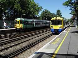
- Sydenham for London Overground and Southern services to London Bridge, London Victoria, East & West Croydon, Clapham Junction, Caterham, Shoreditch High Street and Highbury & Islington. This is the busiest station, with up to 12 trains per hour off peak and a usage of 3.3 million passengers in 2014[29]
- Sydenham Hill and Penge East stations for Southeastern services to London Victoria, Brixton, Bromley South and Orpington.
- Lower Sydenham station also is served by Southeastern but with services to London Charing Cross, London Waterloo East, London Cannon Street, London Bridge, Hayes and Lewisham.
Buses
The area is served by routes 75, 122, 176, 181, 194, 197, 202, 227, 352, 356, 363, 450 and N63 linking Sydenham to Central London, Lewisham, Catford, Croydon, Bromley, Shirley, Elephant & Castle, Blackheath, Forest Hill, Penge, South Norwood and Grove Park.[30][31][32][33]
Roads
The South Circular Road passes close by in Forest Hill. High Street improvements being funded by Transport for London from September 2012 are making the increasingly busy Sydenham Road (A212) more user friendly. So far, Kirkdale to Mayow Road has been completed, with Mayow Road to Kent House Road currently, as of December 2013, being upgraded. The Kent House Road to Bell Green section is still waiting for funding to be found.[34]
Geography

Sydenham is approximately 7 miles to the south east of Charing Cross. It is also at the centre of many of south London's major shopping districts being 3 miles south of Lewisham, 3.2 miles north west of Bromley and 3.5 miles north of Croydon.
Upper Sydenham and Sydenham Hill is located on the large Norwood Ridge formed of London Claygate beds deposits; Sydenham Hill is one of the highest points in London at 367 feet (112 m). Sydenham Hill Wood is a nine-hectare[35] nature reserve located west of Sydenham Hill Road, along with Dulwich and Sydenham Hill Golf course. The hill was once covered by the Great North Wood which covered all of Sydenham, Norwood, Woodside, Gipsy Hill etc. In the 19th Century it was home to the spa and health resort of Sydenham Wells.
The western parts of Sydenham, from Upper Sydenham and Forest Hill towards Crystal Palace Park is a more leafy, suburban area with some parts like the Lawrie Park and Thorpes areas being more affluent than others. Lower Sydenham at the bottom of more gentle slops being east of Upper Sydenham, south of Forest Hill and west of Bellingham. The River Pool, a 5.1 mile tributary of the River Ravensbourne straddles the east of Lower Sydenham along the Hayes railway line.
Climate
The nearest Met Office climate station is based in Greenwich Park:
| Climate data for London (Greenwich) | |||||||||||||
|---|---|---|---|---|---|---|---|---|---|---|---|---|---|
| Month | Jan | Feb | Mar | Apr | May | Jun | Jul | Aug | Sep | Oct | Nov | Dec | Year |
| Record high °C (°F) | 14.0 (57.2) |
19.7 (67.5) |
21.0 (69.8) |
26.9 (80.4) |
31.0 (87.8) |
35.0 (95) |
35.5 (95.9) |
37.5 (99.5) |
30.0 (86) |
28.8 (83.8) |
19.9 (67.8) |
15.0 (59) |
37.5 (99.5) |
| Average high °C (°F) | 8.3 (46.9) |
8.5 (47.3) |
11.4 (52.5) |
14.2 (57.6) |
17.7 (63.9) |
20.7 (69.3) |
23.2 (73.8) |
22.9 (73.2) |
20.1 (68.2) |
15.6 (60.1) |
11.4 (52.5) |
8.6 (47.5) |
15.2 (59.4) |
| Average low °C (°F) | 2.6 (36.7) |
2.4 (36.3) |
4.1 (39.4) |
5.4 (41.7) |
8.4 (47.1) |
11.5 (52.7) |
13.9 (57) |
13.7 (56.7) |
11.2 (52.2) |
8.3 (46.9) |
5.1 (41.2) |
2.8 (37) |
7.5 (45.5) |
| Record low °C (°F) | −10.0 (14) |
−9.0 (15.8) |
−8.0 (17.6) |
−2.0 (28.4) |
−1.0 (30.2) |
5.0 (41) |
7.0 (44.6) |
6.0 (42.8) |
3.0 (37.4) |
−4.0 (24.8) |
−5.0 (23) |
−7.0 (19.4) |
−10.0 (14) |
| Average precipitation mm (inches) | 51.6 (2.031) |
38.2 (1.504) |
40.5 (1.594) |
45.0 (1.772) |
46.5 (1.831) |
47.3 (1.862) |
41.1 (1.618) |
51.6 (2.031) |
50.4 (1.984) |
68.8 (2.709) |
58.0 (2.283) |
53.0 (2.087) |
591.8 (23.299) |
| Avg. rainy days (≥ 1.0 mm) | 10.8 | 8.5 | 9.6 | 9.4 | 9.0 | 8.3 | 8.0 | 7.6 | 8.5 | 10.7 | 10.1 | 9.9 | 110.4 |
| Avg. snowy days | 4 | 4 | 3 | 1 | 0 | 0 | 0 | 0 | 0 | 0 | 1 | 3 | 16 |
| Average relative humidity (%) | 81.0 | 76.0 | 69.0 | 64.0 | 62.0 | 60.0 | 60.0 | 62.0 | 67.0 | 73.0 | 78.0 | 82.0 | 69.5 |
| Mean monthly sunshine hours | 49.9 | 71.4 | 107.1 | 159.8 | 181.2 | 181.0 | 192.1 | 195.1 | 138.9 | 108.1 | 58.5 | 37.4 | 1,480.5 |
| Source #1: Record highs and lows from BBC Weather,[36] except August and February maximum from Met Office[37][38] | |||||||||||||
| Source #2: All other data from Met Office,[39] except for humidity and snow data which are from NOAA[40] | |||||||||||||
| Climate data for London (Heathrow airport 1981−2010) | |||||||||||||
|---|---|---|---|---|---|---|---|---|---|---|---|---|---|
| Month | Jan | Feb | Mar | Apr | May | Jun | Jul | Aug | Sep | Oct | Nov | Dec | Year |
| Average high °C (°F) | 8.1 (46.6) |
8.4 (47.1) |
11.3 (52.3) |
14.2 (57.6) |
17.9 (64.2) |
21.0 (69.8) |
23.5 (74.3) |
23.2 (73.8) |
19.9 (67.8) |
15.5 (59.9) |
11.1 (52) |
8.3 (46.9) |
15.2 (59.4) |
| Average low °C (°F) | 2.3 (36.1) |
2.1 (35.8) |
3.9 (39) |
5.5 (41.9) |
8.7 (47.7) |
11.7 (53.1) |
13.9 (57) |
13.7 (56.7) |
11.4 (52.5) |
8.4 (47.1) |
4.9 (40.8) |
2.7 (36.9) |
7.4 (45.4) |
| Average precipitation mm (inches) | 55.2 (2.173) |
40.9 (1.61) |
41.6 (1.638) |
43.7 (1.72) |
49.4 (1.945) |
45.1 (1.776) |
44.5 (1.752) |
49.5 (1.949) |
49.1 (1.933) |
68.5 (2.697) |
59.0 (2.323) |
55.2 (2.173) |
601.7 (23.689) |
| Avg. rainy days (≥ 1.0 mm) | 11.1 | 8.5 | 9.3 | 9.1 | 8.8 | 8.2 | 7.7 | 7.5 | 8.1 | 10.8 | 10.3 | 10.2 | 109.6 |
| Mean monthly sunshine hours | 61.5 | 77.9 | 114.6 | 168.7 | 198.5 | 204.3 | 212.0 | 204.7 | 149.3 | 116.5 | 72.6 | 52.0 | 1,632.6 |
| Source: Met Office[41] | |||||||||||||
Location
 |
Dulwich | Forest Hill, Perry Vale | Catford, Lewisham | |
| Crystal Palace | |
Bellingham, Southend Village | ||
| ||||
| | ||||
| Upper Norwood, Anerley | Penge, Croydon | Beckenham, Bromley |
Trivia
The Beast of Sydenham of 2005, was a large, panther-like black animal, named Arak, which had been spotted around the area, and attacked a man. The beast was said to be 6 ft in length and 3 ft in height.[42][43]
See also
- Sydenham Hill Wood
- Sydenham School
- Sydenham High School
- Sydenham, Sydney, New South Wales named after Sydenham, London
- The Crystal Palace
References
- ↑ 1.0 1.1 1.2 "Population for every postcode in England & Wales". ONS. Office of National Statistics. Retrieved 18 August 2014.
- ↑ "History of Sydenham". Ideal Homes: A History of South East London Suburbs. Retrieved 29 June 2014.
- ↑ Hadfield 1969, p. 374
- ↑ http://www.ezits.myzen.co.uk/childrensydenham.html
- ↑ Butt, R.V.J. (1995). The Directory of Railway Stations. Yeovil: Patrick Stephens Ltd. p. 237. ISBN 1-85260-508-1. R508.
- ↑ Hill Bagging: Tallest Hills of London Retrieved 9 June 2013
- ↑ BBC News: Blaze at sub-station investigated Retrieved 9 June 2013
- ↑ Currys: Sydenham Store Accessed 30 July 2013
- ↑ B&Q: Sydenham Store Accessed 7 September 2013
- ↑ DTZ: Sydenham, Bell Green Retail Park Retrieved 9 June 2013.
- ↑ SG Smith: Sydenham Accessed 30 July 2013
- ↑ Sydenham Town: The Community Website For SE26 Accessed 30 July 2013
- ↑ Sydenham Society: About Us Accessed 30 July 2013
- ↑ Sydenham Garden: About Us Accessed 30 July 2013
- ↑ News Shopper: Sydenham and Forest Hill win Portas Pilot funding 25 July 2012, Accessed 30 July 2013
- ↑ Sydenham Arts Festival Accessed 30 July 2013
- ↑ London Borough of Southwark: Map of Conservation Areas Accessed 30 July 2013
- ↑ LB Lewisham: Map of Lewishams' conservation areas Accessed 30 July 2013
- ↑ LB Lewisham Accessed 12 June 2013
- ↑ LB Lewisham: Sydenham Wells Park Accessed 12 June 2013
- ↑ LB Bromley: Alexandra Rec Ground Accessed 27 July 2013
- ↑ LB Lewisham: Baxters Field Accessed 12 June 2013
- ↑ LB Lewisham: Home Park Accessed 12 June 2013
- ↑ LB: Lewisham Kirkdale Green Accessed 27 July 2013
- ↑ London Borough of Lewisham: Riverview Park & River Pool Accessed 12 June 2013
- ↑ LB Lewisham: Southend Park Accessed 12 June 2013
- ↑ http://sydenham.org.uk/forum/viewtopic.php?t=1483
- ↑ Lewis, C.T. Courtney. George Baxter (colour printer) his life and work. p. 72. https://archive.org/stream/georgebaxtercol00lewigoog#page/n212/mode/2up
- ↑ Station Usage, Office Of Rail Regulation Accessed 30 July 2013
- ↑ TfL: Buses from Sydenham Accessed 30 July 2013
- ↑ TfL: Buses from Sydenham Hill Accessed 30 July 2013
- ↑ TfL: Buses from Lower Sydenham Accessed 30 July 2013
- ↑ TfL: Buses from Upper Sydenham Accessed 30 July 2013
- ↑ London Borough of Lewisham: Sydenham High Street Accessed 12 June 2013
- ↑ Evans, Humphrey (28 December 2003). "Secret London: Sydenham Hill - The view from the bridge". The Independent on Sunday. Retrieved 19 July 2012.
- ↑ "London, Greater London: Average conditions". BBC Weather Website. BBC Weather. Archived from the original on 28 February 2011.
- ↑ "August 2003 — Hot spell". Met Office Website. Met Office. Archived from the original on 28 February 2011.
- ↑ "Monthly temperature records by country". Met Office Website. Met Office. Retrieved 22 September 2013.
- ↑ "Greenwich 1981−2010 averages". Met Office Website. Met Office. Retrieved 10 April 2013.
- ↑ "NOAA". National Oceanic and Atmospheric Administration. Retrieved 20 October 2013.
- ↑ "Heathrow Climate period: 1981−2010". Met Office Website. Met Office. Retrieved 22 September 2013.
- ↑ "'Big cat' attacks man in garden". BBC News. 20 March 2005. Retrieved 28 January 2007.
- ↑ Barkham, Patrick (25 March 2005). "Fear stalks the streets of Sydenham after resident is attacked by a black cat the size of a labrador". The Guardian (London). Retrieved 28 January 2007.
External links
| Wikimedia Commons has media related to Sydenham. |
- Sydenhamtowncentre.com Town centre website.
- SEE3 Town Team Portas Pilot website for Sydenham/Kirkdale/Forest Hill
- Sydenham.org.uk Community website and forum.
- Sydenham Society Local community group.
- Historical images of Sydenham
| ||||||||||||||||||||||||||||

| ||||||||||||||||||||||||||||||||||||

| ||||||||||||||||||||||||||||||||||||