Swan Island (Victoria)
| Swan Island Victoria | |||||||||||||
|---|---|---|---|---|---|---|---|---|---|---|---|---|---|
|
Map of Swan Island | |||||||||||||
| Postcode(s) | 3225 | ||||||||||||
| Area | 1.40 km2 (0.5 sq mi) | ||||||||||||
| LGA(s) | Borough of Queenscliffe | ||||||||||||
| State electorate(s) | Bellarine | ||||||||||||
| Federal Division(s) | Corangamite | ||||||||||||
| |||||||||||||


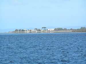
Swan Island is a 1.4 km2 sand barrier island which, with Duck Island and the Edwards Point spit, separate Swan Bay from Port Phillip in Victoria, Australia. It lies close to and north of the town of Queenscliff at the eastern end of the Bellarine Peninsula, and is an official bounded locality of the Borough of Queenscliffe.
Description
Swan Island
Swan Island is home only to the Queenscliff Golf Club, which occupies the western end of the island, and to the Department of Defence, which operates a training facility occupying the central and eastern parts of the island. It also serves as the land access point for the Queenscliff Cruising Yacht Club on Sand Island. It can be reached by a one-lane vehicular bridge and causeway from Queenscliff via the small saltmarsh-covered Rabbit Island. Access to both Swan and Sand Islands is restricted to members of the golf and yacht clubs, Defence Department personnel, or by permit, with the only road guarded by a security gate. The bay between the western and eastern lobes of the island is Stingaree Bight.
Sand Island
Swan Island now adjoins Sand Island, formed by the cutting of a channel between Port Phillip and Swan Bay to make the entrance to Queenscliff Harbour. The continual maintenance pumping of sand from the harbour's entrance channel to keep it navigable has resulted in longshore drift of sand north-eastwards to connect Sand Island with Swan Island and create two lagoons.
Environment
Swan Island's natural vegetation includes areas of coastal scrub, relict patches of coastal woodland and extensive areas of saltmarsh. The island is part of the Swan Bay and Port Phillip Bay Islands Important Bird Area, identified as such by BirdLife International because of its importance for orange-bellied parrots, waders and seabirds.[1] It is ornithologically notable for the critically endangered orange-bellied parrot, for which the saltmarsh serves as one of its few regular wintering sites. Sand Island contains saltmarsh-fringed lagoons bordered in the east by colonising shrubs and grasses on newly formed dunes; its accreting eastern beach, now connected to Swan Island, forms an important high tide roosting area for the migratory waders that feed on the Swan Bay mudflats at low tide, while the lagoons are much used by black swans and other waterbirds.
History
The island was named by Acting Lieutenant John Murray when he entered Port Phillip in the ship Lady Nelson in February 1802.[2]
Swan Island has a long history of military use, being part of the fortifications built to protect the entrance to Port Phillip Bay from a feared Russian invasion during the Crimean war in the 1850s. The fortifications of Swan Island were controlled by the fire command at Fort Queenscliff. During the First World War it was used as a depot for naval mines.[3]
The island was linked to the Queenscliff railway station by a 3-foot gauge tramway for transport of goods for military purposes between 1886 and 1958.[4][5]
Shipwrecks
The wooden cargo brig Mountain Maid sank off Swan Island in 1856 following a collision with another vessel. It is a well known dive wreck.
The J-class submarine HMAS J3 was scuttled off the north-east point of Swan Island in 1924 once its services were no longer required.
Department of Defence activities
The Department of Defence prefers not to discuss what currently goes on at the island, and information on the facility, aside from its history, is not found on any government website. It is said that "Less is known about what goes on at Swan Island than is known about Pine Gap".[6] Current use includes an exercise area where Australia's Special Forces carry out counter terrorism training. It has been described as a finishing school for learning "non-gun stuff".[3][7] The base is shared with the Australian Secret Intelligence Service.[8] Although the exact nature of ASIS's activities on the island is undisclosed, newspapers have reported that Swan Island is a finishing school for counter-insurgency and guerrilla warfare operatives, that the SAS and Australia's overseas spies from ASIS conduct joint exercises at the base, and that it is also used for weapons and counter insurgency training and top-secret briefings.[9] The base includes a small demolition range, used by the Australian Army.[10]
See also
- Fort Monckton, the site that is alleged to be the United Kingdom, Secret Intelligence Service's field operations training centre
References
- ↑ "IBA: Swan Bay and Port Phillip Bay Islands". Birdata. Birds Australia. Retrieved 2011-10-26.
- ↑ Ida Lee (Mrs. Charles Bruce Marriott) (1915), The logbooks of the 'Lady Nelson,' with the journal of her first commander Lieutenant James Grant., London: Grafton, p. 135, OL 6580132M
- ↑ 3.0 3.1 McPhedran, Ian; Mark Buttler (2007-04-10). "Mystery island for our spies". Herald Sun (News Limited). Retrieved 2007-04-10.
- ↑ "Bellarine Peninsula Railway - History". www.bpr.org.au. Retrieved 2009-06-03.
- ↑ "Rail Geelong - Queenscliff Station". www.railgeelong.com. Retrieved 2009-06-03.
- ↑ Nicholson, Brendan (2007-04-10). "Swan Island: top secret training area for agents". The Age (Melbourne).
- ↑ Nguyen, Kenneth; Ben Cubby; Christian Catalano (2007-04-10). "Plunge into bay kills three soldiers". Sydney Morning Herald (Fairfax). Retrieved 2007-04-10.
- ↑ Toohey, Brian; William Pinwell (1990). Oyster: The Story of the Australian Secret Intelligence Agency.
- ↑ http://www.heraldsun.com.au/news/national/diggers-crash-death-mystery/story-e6frf7l6-1111113312629
- ↑ Holroyd, Jane (2007-04-09). "Counter terror trio die in crash". Sydney Morning Herald (Fairfax). Retrieved 2007-04-10.
External links
- Commonwealth Heritage Sites in Victoria
- Queenscliff Golf Club
- History of Russian Attack fears and fortifications
- Fort Queenscliff Museum
| ||||||
| ||||||||||||||||||||||||||||||
Coordinates: 38°15′00″S 144°40′45″E / 38.25000°S 144.67917°E