Sutton, London
| Sutton | ||||||
From top, left to right: taxi turning outside Sutton railway station; clocktower of the Thomas Wall Centre; Trinity Church's crown and lantern spire; fountain in Manor Park |
||||||
 Sutton |
||||||
| Population | 41,483 [1] | |||||
|---|---|---|---|---|---|---|
| OS grid reference | TQ255645 | |||||
| – Charing Cross | 10.5 mi (16.9 km) NNE | |||||
| London borough | Sutton | |||||
| Ceremonial county | Greater London | |||||
| Region | London | |||||
| Country | England | |||||
| Sovereign state | United Kingdom | |||||
| Post town | SUTTON | |||||
| Postcode district | SM1 SM2 SM3 | |||||
| Dialling code | 020 | |||||
| Police | Metropolitan | |||||
| Fire | London | |||||
| Ambulance | London | |||||
| EU Parliament | London | |||||
| UK Parliament | Sutton and Cheam | |||||
| London Assembly | Croydon and Sutton | |||||


Coordinates: 51°21′56″N 0°11′47″W / 51.3656°N 0.1963°W

Sutton is the principal town of the London Borough of Sutton in South London, England. It lies on the lower slopes of the North Downs, and has the administrative headquarters of the borough. It is located 10.5 miles (16.9 km) south-south west of Charing Cross, and is one of the eleven metropolitan centres identified in the London Plan.[2]
An ancient parish in the county of Surrey, Sutton is recorded in the Domesday Book of 1086 as having two churches and two acres of meadow at that time. Sutton's location on the London to Brighton turnpike from 1755 led to the establishment of coaching inns, spurring its further development as a village. When it was connected to central London by rail in 1847, the village began to grow into a town, and there was significant Victorian-era expansion, both commercially and residentially. Sutton's expansion and increase in population accelerated in the 20th century as part of the suburban growth of London. It became a municipal borough with neighbouring Cheam in 1934, and has formed part of Greater London since 1965.[3]
Sutton has a theatre, the largest library in the borough, several works of public art, four conservation areas and a park and green at either end of the high street. It contains a civic and retail district, a business sector, including a number of large international companies, and the sixth most important shopping area in London, centred on Sutton High Street. Sutton mainline railway station is the largest in the borough, with frequent services to central London among other destinations. Along with Wimbledon Studios, Sutton is a hub for filming in south-west London.[4] Sutton is home to the Royal Marsden Hospital and the Institute of Cancer Research; there are plans to create the world's second biggest cancer research campus on the site. The town has among the lowest levels of crime in Greater London.
Sutton is home to a significant number of the borough's schools, within a borough which is among the top performing authorities for education in the country.
History
Origin of the name
| 1881 | 10,334 |
|---|---|
| 1891 | 13,977 |
| 1901 | 17,223 |
| 1911 | 21,270 |
| 1921 | 21,063 |
| 1931 | 27,989 |
| Absorbed by Sutton and Cheam parish ► | |
| source: UK census[5] | |
The placename Sutton is recorded in the 1086 Domesday Book as Sudtone.[6] It is formed from Old English 'sūth' and 'tūn', meaning 'the south farm'. It was probably in relation to Mitcham and Morden that it was considered southerly.[6] The name was later applied to Sutton Common and the Sutton New Town development in the 19th century.[6]
Pre 1700
Archaeological finds in the region date back over ten thousand years, but the first substantial evidence of habitation comes from the excavation of a Roman villa in Beddington. An implement from the neolithic age was discovered close to the junction of Sutton High Street and Carshalton Road.[7] The Roman road of Stane Street forms part of the northern boundary of the parish of Sutton. The course of Stane Street through the area is now followed by the modern roads Stonecot Hill and London Road, and designated A24 on road maps.
William The Conqueror's Domesday Book of 1086 assesses Sudtone:
In the time of King Edward it was assessed at 30 hides; now at 8½ hides. There are 2 carucates in the demesne, and 29 villains and 4 cottars with 13 carucates. There are 2 churches, and 2 bondmen, and 2 acres (8,100 m2) of meadow. The wood yields 10 swine. In the time of King Edward it was valued at 20 pounds, now at 15 pounds.
The Domesday Book adds that Sutton was about 800 acres in size, and had about 30 houses and a population of about 200.[8] It also states that the Abbot of Chertsey held the Manor. This remained so until 1538 when the Manor was sold to King Henry VIII, along with the manors of Ebisham (Epsom), Coulsdon, and Horley. They were all then granted to Sir Nicholas Carew of Beddington in that same year. When Sir Nicholas was sentenced to death for treason, the King seized the manors, and they remained possessions of the Crown until King Edward VI granted part of them to Thomas, Lord of D'Arcy of Cliché, but kept the Manors of Sutton, Ebisham and Coulsdon.[9] Queen Mary later restored the whole of these manors to Francis, only son of Sir Nicholas Carew. At a later date, and for unknown reasons, the Manor once more became possession of the Crown until King Charles II granted it to the Duke of Portland in 1663, who sold it in 1669 to Sir Robert Long, who sold it that same year to Sir Richard Mason. The Manor sold almost all of its land and has regularly changed hands since.[9]
From the time of Domesday until the 19th century establishment of local government and disestablishment of hundred courts, Sutton formed a parish in the Wallington hundred of Surrey, in the feudal system.[10][11] However, by the time of Richard II, the parish was not required to do suit and pay feudal dues at the Hundred Court—probably the parish was exempt on account of liberties enjoyed by its lord.[12]
1700 to 1900

In 1755, a turnpike road from London to Brighton was constructed, meeting with a turnpike road from Carshalton to Ewell which was constructed at the same time. The toll bars for Cheam Road and Brighton Road were originally located at right angles to each other by the Cock Hotel, a coaching inn that sat on the south-east corner of the junction of the turnpikes. The inn's sign straddled the Brighton road, and its proprietor was the champion pugilist, "Gentleman" Jackson.[13] Its name originated from the cock horses needed along this part of the road. Twenty horse and carts passed up and down this stretch in a day. The London to Brighton stagecoach began in 1760, and the Cock Hotel was the 9 a.m. breakfast stop for coaches leaving the city two hours earlier. Regular contact beyond the town brought both expansion and sophistication. Small businesses opened up, at first directly related to travellers on the turnpike – bakers and brewers to feed visitors, seamstresses to provide running repairs and leather workers to make or mend harnesses – and then to provide trade goods for neighbouring communities.[8] All three of the toll bars moved further away from the junction after a number of years to take account of account of Sutton's expansion. The northernmost toll bar was situated where Rosehill is now. The toll bars remained in effect until 1882.


Sutton railway station was opened on 10 May 1847. Following the arrival of the new, fast link to central London, Sutton's population more than doubled between 1851 and 1861, and the village developed into a town. New housing to accommodate this growth was constructed in the Lind Road area, and called the "New Town". Today A pub on the corner of Lind Road and Greyhound Road is called The New Town. Another was named the Jenny Lind (now the Nightingale), after the famous Swedish opera singer who was visiting friends in the area in 1847 and enchanted locals with her singing.[8]
Sutton Water Company was incorporated in 1863, and the provision of water mains finally allowed houses to be built outside of the area defined by the water-yielding Thanet Sands. The Lord of the Manor at the time, Mr Thomas Alcock, sold land that was previously unsuitable for residential buildings, making it available for new construction. Sutton's population more than doubled again in the next ten years between 1861 and 1871.
The 1870-1872 Imperial Gazetteer of England and Wales describes Sutton:
Sutton, a village and a parish in Epsom district, Surrey. The village stands adjacent to the Epsom railway, 4½ miles WSW of Croydon; consists chiefly of one street; is the head polling place for Mid-Surrey; and has a post-office under London S, a railway station with telegraph, and two hotels.—The parish includes Ben-hilton group of new villas at Been Hill, numerous other new villas and cottages, and the South Metropolitan District school. Acres, 1,803. Real property, £12,061; of which £30 are in gasworks. ...[15]
The High Street near the top was known as Cock Hill until the 1880s – the shops on the east side were built in 1880, ten years later than those on the west side.[16] A notable building to appear around this time was the grand and decorative London and Provincial Bank building (now home to Barclays Bank), which was built overlooking the historic crossroads in 1894. It is four storeys tall and forms a prominent landmark when arriving in the town centre from a westerly direction. There is a series of arches at ground level, and the main entrance is on the corner where the two roads meet, rounded in shape and surrounded by an ornate architrave and segmental pediment.[7][14][17][18]
In 1884 Sutton High School for Girls was founded by the then Girls' Public Day School Trust. In 1899 Sutton County Grammar School (now Sutton Grammar School for Boys) opened, initially with just nineteen pupils.
In 1897 Sutton Masonic Hall was built in Grove Road by freemasons from the locality. Freemasons have met there since its foundation, apart from two intervals during the First and Second World Wars when the military requisitioned the hall. It also served as a temporary shelter for people displaced from their homes.[19] It was built by a locally known architect, Richard Creed, and local builder, Duncan Stuart & Sons of Wallington. The building features three central bays projecting under a tympanum, supported by pilasters on the second storey.[14]
In 1896 to 1898 a new Cock Hotel was built on an adjacent site to the north of the original one, which was demolished shortly afterwards.[20]
20th Century
.jpg)
%2C_Greater_London.JPG)

.jpg)
As of 1901, the town's population had reached 17,223, as it attracted upper middle class commuters, including City workers.[21] By the beginning of the 20th Century, the High Street had become heavily built up.[22] By the late 1930s some of the shops had inevitably altered, but the buildings above remained much the same.
In 1902 the Banstead Road site of the South Metropolitan Industrial school was bought by the Metropolitan Asylums Board. The site later became the Downs Schools and then the Downs Hospital. It is now shared between the Royal Marsden and Sutton Hospitals and the Institute of Cancer Research.[23]
Sutton's main post office moved into new premises adjacent to the Masonic Hall on Grove Road in 1907 from its former site at 14 High Street.[8]
The Sutton Adult School and Institute opened in 1910 and 1911 in a large Edwardian building in Benhill Avenue. It later became the Thomas Wall Centre,[24] named after the area's benefactor of Wall's sausage and ice cream fame.
In 1934 Sutton Baptist church opened in the town centre, a short distance from the existing St Nicholas Church and Trinity Church.
During World War II bombing was not as heavy as in central London; despite this, the Commonwealth War Graves Commission lists 187 civilian casualties for Sutton and Cheam. Between 1940 and 1944 a total of 434 bombs were dropped on Sutton and Cheam, and a local "bomb map" was produced after the war recording the date, time, location and type of each bomb.[25]
In 1950, in order to widen the High Street, the Cock Hotel was demolished, and not rebuilt. However, the inn sign, complete with its finger-posts, survives overlooking the historic town-centre crossroads. Another former pub was the Greyhound, which in 1932 had a gantry sign over the High Street. The pub's name survives in the street name Greyhound Road.[26]
In 1959 a local resident, George Edgar Alcock, started a campaign to preserve a unique avenue of Copper Beech trees. This campaign led the same year to the formation of the Sutton and Cheam Society, a local amenity group which still exists today and of which Mr Alcock was secretary for many years. A plaque commemorating his life is situated at the junction of the road Christchurch Park with Brighton Road.[27]
Governance
Sutton came within the area of the Metropolitan Police District in 1840. The parish authorities lost control of poor relief in 1834 when the parish was grouped into Epsom Poor Law Union. This led to the parish forming part of the Epsom Rural Sanitary District from 1875. The parish of Sutton adopted the Local Government Act 1858 in 1882 and a local board was formed to govern the area, which was constituted a local government district. The Local Government Act 1894 reformed it as Sutton Urban District, governed by an urban district council.
In 1928 the area of the urban district was expanded, by the addition of the parish of Cheam. The urban district was renamed Sutton and Cheam to reflect this. The urban district council successfully petitioned for a charter of incorporation and the town became a municipal borough in 1934. Having only nominal existence within a municipal borough, the civil parishes were merged in 1949.[10] The municipal borough was abolished in 1965 and its former area became part of the London Borough of Sutton in Greater London.
For Westminster elections, Sutton is part of the Sutton and Cheam constituency, which was formed in 1945. The sitting Member of Parliament for the constituency is Paul Burstow, a member of the Liberal Democratic Party.
Population and demographics
Most of Sutton, including the town centre, falls under the SM1 postcode area, though places south of Sutton railway station are part of SM2 instead. The population of the town, comprising the Sutton Central, Sutton West, Sutton North and Sutton South wards, was 41,483 in the 2011 census.[28]
A majority of the town's population is in the ABC1 social group.[29]
Geography

Geology, soil and elevations
Sutton is one of several towns located on a narrow bed of Thanet Sands which extends from Croydon in the east, to Epsom in the west. To the south of this belt is chalk of the North Downs, and to the north is clay. The belt of Thanet sands allowed wells to provide clean water, whereas the clay to the north mostly offered surface water of unsuitable quality. This feature attracted settlements to the sand belt from a very early date. In 1863 the Sutton and Cheam Water Company began to supply water to the parish of Sutton. It is now part of the Sutton and East Surrey Water.[30]
Elevations range from 115m AOD in the south of Belmont (a contiguous neighbourhood formerly considered part of the town) (or 85m on the borders of the two places, south of the railway station)[31] to 29-33m in the Sutton Common and Benhilton neighbourhoods which are north of the High Street and at the start of the Pyl Brook, the major tributary of the Beverley Brook.[32]

Location
Sutton has formed part of Greater London since 1965.[3] Despite this, "Sutton, Surrey" is commonly used for addresses in the town. Apart from being inaccurate, this is also problematic as there is another, much smaller Sutton in Surrey proper, about five miles south-west of Dorking.[33] Sutton mainline railway station is known as "Sutton (Surrey)" by Southern Railway Ltd.[34]
Elevation
Sutton lies around 50 metres (160 ft) above sea level.
Architecture


Sutton is mainly the product of the railways, which arrived in the town in the mid-nineteenth century. So, although it already existed (as a village with coaching inns) in the horse and carriage era, most of the town's earliest architecture is Victorian. A number of buildings - for example St Nicholas Church (see below) - do, however, date from before the Victorian era. The Georgian Sutton Lodge on Brighton Road is one of the town's oldest buildings. Built in 1762 by one John Wells, a brewer, it was the farmhouse of the former Sutton Farm. It was also used by the future King George IV who took his mistresses there, but it is now a day centre for the over 60s.[8][35]
The High Street and the central area housing has a majority of Victorian architecture; Edwardian architecture is also represented, especially among the town's housing stock. Of architectural interest because of its particularly varied style is the Victorian residential quarter east of the high street known as Newtown. The variety resulted from the fact that no single developer was in overall charge, with instead several different builders being responsible for their own small plots.[8]
The town also features a variety of more recent architectural eras and styles from the 1930s (including some art deco and moderne) right up to the 21st century. The three most prominent examples of the latter are the Aspects of Sutton and Lamborne apartment buildings and the new police station extension. Aspects was created out of a former office building; it was reclad in a terracotta colour and three additional floors were added at the top to house a number of penthouses, and, with a total of eighteen floors, it can be seen from across Sutton. By contrast, the slightly less tall Docklands-style Lamborne building is completely newly built; it is finished in white with wooden inserts and is balconied throughout.

In 2003 the extension to Sutton Police Station was completed and officially opened the following year by Commissioner Sir John Stevens. The extension, which is far larger than the original Edwardian listed building to which it is attached, is used by Sutton CID, the criminal justice unit and the borough intelligence unit.[8]
Conservation areas
There are four Conservation areas in the town of Sutton itself (among several others within the wider borough). One of these is in the town centre, while the other three are residential—Landseer Road, Sutton Garden Suburb and Grove Avenue.[36]
Town Centre High St Crossroads Conservation Area

The Sutton Town Centre High Street Crossroads Conservation Area was designated on 9 May 2011, following a review of the town centre, which highlighted the historic importance of the highway network at the crossroads of Cheam Road/Carshalton Road and the High Street, as well as the associated buildings and spaces. The Conservation Area focuses on the area around the historic crossroads, and stretches from the Station down to Trinity Square. The local authority noted that the buildings, especially their upper storeys, were worthy of preservation and enhancement.[37] Its report concluded that Conservation status was warranted on the basis of the historic importance of the area together with its architectural and aesthetic merit. The designation would enable the provision of guidance to landowners and developers on maintaining and improving the historic aspects of the area.[14]
Gordon Rookledge in his "Sutton Architectural Identifier" remarks on the "vivid, Victorian, polychrome brick and stone façades" in his description of Sutton High Street.[36]


Landseer Road Conservation Area
Landseer Road Conservation Area includes Landseer Road itself plus all or most of the nearby Bridgefield Road, York Road, Derby Road, Cecil Road and Salisbury Avenue; and short sections of Cheam Road and Grove Road.[36][38] It was designated 1992, is nine hectares in size, comprises 138 properties, and is located between Sutton town centre and Cheam Village. Most of the houses are large detached villas. The grandeur of the houses is a notable feature of the area, which is surrounded by mature trees and grass verges.[39]
The development of these roads began in the late nineteenth century and was fully completed in 1913. The roads are lined with, according to Gordon Rookledge, the "finest, detailed Edwardian detached and semi-detached houses" in Sutton Borough.[36]
The Sutton Garden Suburb Conservation Area
The Sutton Garden Suburb is in North Sutton. Thomas Wall, famous for his sausages and ice cream, developed the Sutton Garden Suburb between 1912 and 1914. This suburb contributed to the Garden City movement that was originally conceived by Ebenezer Howard and was similar to the development of the Hampstead Garden Suburb in North London. It was designated a conservation area in 1989. Designed by F. Cavendish Pearson, it has an integrated house and landscape design, some secreted around small greens and others along well-planted avenues.[36]
Grove Avenue Conservation Area
Grove Avenue Conservation Area was built as a private estate in the 1920s or early 1930s. It is situated between Grove Road and Cheam Road, near the Landseer Road Conservation Area. The properties consist of single blocks, each containing four maisonettes, presenting a symmetrical facade to the road. The blocks are alternately built in modernist, or half timbered styles. Many of the details survive, including iron-framed windows, hand-painted number and instruction boards, garage facades, front-garden walls, tree plantings and the estate gate-piers.[36]
Russettings

Russettings is a large house built in 1899 on a three-quarters of an acre plot at 25 Worcester Road. It was among the last of a number of similar upper middle-class houses built in the latter part of the nineteeth century in this and neighbouring roads. It was originally occupied by George Smith and his wife Mary, who was the sister of local benefactor Thomas Wall. Smith had his initials GS put on the façade of the red-brick building, which was designed by Frederick Wheeler in an Arts and Crafts style. Features include gabled roofs, large chimneys, bay windows, a green copper dome and a porch with a tiled roof and marble floor. With the newly formed London Borough of Sutton in 1965, the house became the Sutton Register Office and was refurbished in 1994 to provide accommodation for the registration of births, marriages and deaths and a marriage suite.[40]
Churches
Three main churches are in the town centre: Trinity Church, which is a United Reformed and Methodist church; Sutton Baptist Church, and St. Nicholas Church (Anglican). Trinity Church and St Nicholas Church are opposite each other on the western street parallel to the High Street, while the Baptist Church is situated nearby, in Cheam Road. The Salvation Army have a centre for meetings and helping people through problems in Benhill Avenue. Among a number of others in the vicinity of the town, there are also All Saints Church just to the north of the town centre, St Barnabas to the east and Christ Church to the south.
Trinity United Reformed and Methodist Church
The Grade II listed Trinity Church is traditional in style, with its exterior in Kent ragstone. Its "crown and lantern" spire, however, is a very unusual feature, shared with two cathedrals — St Giles' Cathedral in Edinburgh and Newcastle Cathedral. The present building, officially opened on 2 October 1907, was renamed Trinity Methodist Church following the Methodist Union in 1932. In 1972 the Congregational and Presbyterian Churches united, and the Congregational and Methodist congregations in Sutton also united, with Trinity becoming a joint United Reformed and Methodist church.
The interior resembles the design of a traditional parish church, except that the wider nave means that everyone in the congregation has an uninterrupted view of the pulpit - an indication of the importance the church gives to preaching. There are a number of war memorials, taken from the Congregational church, fixed to the south wall. A new church organ was installed in 1922 - originally built in 1912 for a country mansion in Northamptonshire, it was reconstructed for church use and specially adapted to fit in with the church woodwork. 1991 saw the opening of the church's "Oasis Caf". The exterior of Trinity Church forms a distinctive landmark for the town, owing to the prominent position of the church and the rare crown and lantern spire.[41]

Sutton Baptist Church
In contrast to the other two town centre churches, the Baptist Church is relatively modern—it was designed by the architect Nugent Cachemaille-Day (1896-1976) using mainly traditional materials, such as brick and tile, in a style influenced by the Arts and Crafts Movement. Built by Messrs. Pitchers Ltd. of Holloway, the church took little more than half-a-year to build, commencing in January 1934 and opening in September the same year, and its notable design aroused interest not only locally, but in church and architectural circles nationwide.
The church is considered one of the best examples of a contemporary brick building in the Borough of Sutton. The bold design has imposing proportions with long walls and concave sweeps in the moderne style. The windows are in simple clean lines, in a simplified Gothic style. The interior is considered equally dramatic, with much exposed brickwork and sweeping pointed arches, which are highlighted by the directions in which the bricks are laid, and its clean simplicity is in tune with the ideals of the Arts and Crafts Movement, referred to above, as well as the later modern architectural movements.[42]
St Nicholas Church

The Grade II listed St Nicholas Church[43] is the oldest of the three town centre churches, and is surrounded by a small ancient graveyard, which is wooded. It also contains some lawned areas with benches. Two well used public footpaths run through these grounds. It is in ecumenical partnership with other denominations and in a Team Ministry with other Anglican churches.
The present building stands on a site that has been used as a church since Saxon times - an earlier, smaller church occupied the site until the nineteenth century, which apart from its piscina was replaced by the present church building, which was consecrated in February 1864. It was designed by Edwin Nash, an architect involved in church restoration, whose son lived in Sutton Common Road. The vestry on the north side of the chancel was added in the late 19th century, as was the church's stained glass.[44]
In 2014 the church is celebrating its 150th anniversary with an exhibition and public talks about the history of the town, the church and people associated with the church.[45][46]
All Saints Church
Just to the north of Sutton town centre in All Saints Road is All Saints Church, Benhilton. Its parish was created in 1863, and the foundation stone of the Grade II* listed building was laid in the same year, designed by Samuel Teulon in the Gothic Revival style.[47] The building owed much to Thomas Alcock who was then lord of the manor and gave £18,000 towards the building, plus the land for the church, the vicarage and a school. The church was conceived as an amenity for an estate of upper class Victorian housing which Alcock was developing on the land to the east.
The nave and south aisle were finished first, the tower and chancel were added in 1867, while the north aisle was not fully roofed until 1906. The church has always been noted for its bells; the first was the tenor bell, which was presented by Thomas Alcock and was rung on the day the church was consecrated. The framework for a complete peel was fixed in the tower in 1877. Another bell was added the same year, and a third the year after. There were six by 1882 and all eight had been inaugurated by 1893.[48]
Christ Church
.jpg)
To the south of the town centre in Christchurch Park sits Christ Church, Sutton. It was built in 1888 by architects Newman & Jacques and builders Gregory and Company of Clapham for £8,000. It was sited among the then lavender fields east of Brighton Road. Additions were made ca 1910 to 1912 by J D Round. The church has the largest auditorium in Sutton, and comprises a nave of five bays, a chancel, apse, north and south aisles, chapel, narthex and vestries.[49] [50]
St. Barnabas Church
To the east of the town centre is St Barnabas Church, which was built between 1882 and 1884 by architects R H Carpenter and Benjamin Ingelow. Its purpose was to serve the Newtown area of Sutton, which was developed in the second half of the 19th Century. Architecturally, it is a red brick building with stone dressings, and is in the Gothic Revival style. Its nave has five bays, and is supported inside by columns with clustered shafts and a timber scissors truss roof.[51]
Green spaces
.jpg)


.jpg)
In addition to the St Nicholas church grounds, there are two larger areas of green space within the town centre:
Sutton Green is located at the lower (northern) end of the high street, near All Saints Church. It is bordered by a row of detached Victorian villas on one side, and by the high street on the other. Victoria Gardens, a smaller area of green space, lies the other side of Bushy Road from Sutton Green.
Just to the north of Sutton Green there is more extensive green space in the form of Sutton Common, which originally (until the beginning of the nineteenth century) encompassed Sutton Green.[52] Today a portion of the Common houses a major junior tennis facility. The Common is situated both to the east and west of Angel Hill.
Manor Park is situated opposite the police station. The park was officially opened by the Chairman of the then Sutton Urban District Council in 1914, and its fountain was added in 1924-5.[53] A plaque on the pool surround states: "This fountain was presented to the town by Councillor Chas Yates Chairman of Sutton U.D.C.1924-25"[54]
Manor park is the site of the Sutton War Memorial. The memorial was unveiled at a service in June 1921 by Sir Ralph Forster, a wealthy local resident whose son died in the war.[55][56] The memorial, in portland stone, consists of a large ornamental cross on a plinth.
524 men who died in the First World War are commemorated on the memorial. In addition, it has four panels, one containing an inscription, the other three containing the emblems representing the Army, Navy and R.A.F.
The inscription reads: "This sign of the great sacrifice is raised in honour of OUR HEROIC DEAD, who gave their lives for England in the Great War. Their name liveth for evermore"
There are also four angels on the plinth overlooking the park.[57]
The current Manor Park Café opened in October 2010, replacing an earlier one. This eco-friendly, thirty-seat café has a range of environmental features, in particular its straw-bale construction. The café building was erected using UK produced straw-bales and natural sustainable materials, a type of construction which means that the building could last for longer than 200 years. It was designed by Amazonails Architectura designers, and constructed by a mixed team of builders.[58] It was London’s first energy-efficient building to use this method of construction.[59]
In the south of Sutton starts Banstead Downs, which extends for around a mile further south towards neighbouring Banstead. Banstead Downs is a large Site of Special Scientific Interest, covering 430 acres (170 ha). Banstead Golf Course is on the northern slopes.
- Local Nature Reserves
Sutton contains two Local Nature Reserves.[60]
- The Anton Crescent Wetland reserve has ponds, willow carr and reedbeds, and the ponds never dry out as the rock formation is Oxford Clay. The pools and mud provide a habitat for birds such as the green sandpiper and common snipe. In 2005/6 the Environment Agency funded the installation of a pond-dipping platform and boardwalk.[61]
- Devonshire Avenue Nature Area is a Site of Borough Importance for Nature Conservation, Grade II. It is mainly neutral grassland, but it also has areas of chalk grassland, scrub and trees. A notable species is the small blue butterfly, which is rare in the borough. Plants include the nationally scarce ivy broomrape, and kidney vetch and bird's-foot trefoil.[62]
 |
Morden, Wimbledon | Rose Hill | Benhilton | |
| North Cheam, Worcester Park | |
Carshalton | ||
| ||||
| | ||||
| Cheam | Belmont, Banstead | Carshalton Beeches, Wallington |
Culture
Sutton has a range of public art, a large library, a music venue and a cinema and theatre. It is also a hub for filming in south-west London.[4][63]
.jpg)
Public art
The town centre features six examples of public art.
Murals
Three of the six works are creations on the side walls of buildings.

- Heritage Mosaic
In addition, there is a large town centre mosaic measuring 9 metres (30 ft) high and 5 metres (16 ft) wide, and covering the whole of another three storey wall in the town square near the Waterstone's bookshop. One of the largest examples of wall art in Britain, it was commissioned by the London Borough of Sutton to celebrate the borough's heritage. [64] Created by Drostle and Turner, the mosaic was made from vitreous ceramic tesserae (small tiles made of glass and clay), and put in place in 1994. Consisting of well over 100,000 pieces, the mosaic took over 1,500 hours to design and construct.[8]
It was designed by Rob Turner, and shows several aspects of Sutton's heritage and local history in a classical geometric pattern with nineteen black and white panels set against a multi-colour background. The centre-piece is the depiction of Henry VIII's palace at Nonsuch. Other panels depict armorial bearers from the old local families, as well as industrial and architectural heritage.[65]
A plaque describing the panels was installed in 2011, and unveiled by Councillor Graham Tope, Executive Member for Community Safety, Leisure and Libraries, who said:
This beautiful mosaic has been a much-loved feature of our High Street for the past 17 years, but unless you're a historian the chances are you would not know what all of the intricate panels mean. I hope this plaque will encourage people to take a look, and for those already familiar with the mosaic, I hope it will help them to appreciate it even more."[64]
- Wellesley Road Mural
.JPG)
There is a third example of such building-height wall art, situated in Wellesley Road, about a hundred yards south of the mainline railway station. It was created by the street artist, Eva Mena, who is from Bilbao in Spain and a leading practitioner in the urban art movement. The mural dates from 2008,[66] and was completed in three days.[67]
It was specially-commissioned by the owner of a cleaning firm keen to promote local art, and depicts an image of Erykah Badu, the American singer-songwriter, record producer, activist and actress. It shows her head, face and shoulders, with beads and multiple bangles which she is wearing held up in front of her, while pink and purple flower petals complete the image. The painting covers the entire side wall of Indepth House, a small office building occupied by the cleaning firm.
- Twin towns mural
The twin towns mural consists of a set of seven individual murals on one side wall depicting scenes of the London Borough of Sutton and its four European twins:[68] Gagny, a suburb of Paris; Gladsaxe (a suburb of Copenhagen) in Denmark; Minden in Germany; and Charlottenburg-Wilmersdorf in Berlin. The paintings are inset within seven mock window frames, positioned along the north flank of a Victorian commercial building at the southern end of the High Street near the train station at the junction with Sutton Court Road.
The murals were designed and painted (on to plywood) by professional public artists artists Gary Drostle and Rob Turner and were unveiled in 1993 to commemorate the 25th anniversary of Sutton's twinning with Wilmersdorf. The five twins are each painted with their heraldic shield above images of their key features. Each twin also has its own plant to symbolise its environmental awareness; in the case of Sutton this is in a separate smaller painting above the main one and depicts a beech tree, from which Carshalton Beeches in the borough derives its name.[69] In 2011 an information board was installed by the local council in the street facing the mural.[70]
Sculptures

- Armillary
In addition to the wall art, there is a Millennium Dial armillary, which was dedicated to the town in the year 2000 by the Rotary Club. It is in the form of an historical timepiece, and it serves three purposes: firstly, simply to tell the time; secondly, to commemorate time through various inscriptions including the Rotary motto "Service Above Self" and distances to nearby areas such as Kingston upon Thames; and thirdly, to commemorate the work which the Rotary Club has done.[71]
The Sutton armillary is a popular feature of the town, and it continues to provide a focus for the town centre.[72] It will remain as a permanent memorial, marking not just the new millennium but also the central part that the Rotary has played in the welfare of Sutton since 1923.
It was originally installed in the centre of a small "Millennium Garden", but was slightly re-positioned in 2011, since when it has stood on the edge of the new central square in the town, directly in front of a bookshop.


Since 1981 two outside sculptures have been installed.
- The Messenger
First, The Messenger statue, a sculpture in bronze with very dark patination completed by David Wynne, OBE in 1981 of a large horse and rider. The horse, with a slightly raised left leg, looks towards the railway station. The rider, seated bareback, raises his left hand in the air above his head and his right hand to his mouth, as if calling. It is fully life-size and mounted on a 7 foot plinth of marble and granite slabs. The total height is 150 inches.[73]
It was a major commission for the sculptor, which took four years from his first idea and inspiration on receipt of the brief through roughing out, refining and foundry to the final unveiling and installation.[74] The creation is located directly outside the main entrance to Quadrant House (in the Quadrant), adjacent to the railway station.
- Transpose 2002
Secondly, the Transpose 2002 sculpture by Michael Dan Archer, located at the junction of Carshalton Road and Langley Park Road, about 250 yards from the town's historic central crossroads. It is 7 metres (23 feet) in height, 1.5 metres (5 feet) in width and 1.5 metres in depth, and made of Chinese granite and stainless steel.[75]
It was commissioned jointly by Chartwell Land, B&Q and the London Borough of Sutton. As its name suggests, it dates from 2002. Archer says his sculptures "primarily invoke the massiveness and physicality of stone and its relationship to architecture, humanity and landscape". The design, location and dimensions of Transpose 2002 all combine to make it a significant landmark for those entering Sutton town centre from an easterly direction along Carshalton Road.
Literary facilities
Sutton Library is situated close to the top of the town, near St Nicholas Church and the Holiday Inn Hotel, and is part of a complex which contains the Civic Offices, home of Sutton Borough Council, and the Sutton College of Liberal Arts. It is the largest library in the borough. Opened in 1975, it was extensively refurbished in 2004 to meet changing customer needs. It was the first public library to appoint a library writer-in-residence; the first to establish a CD and video lending library; and the first to offer a full public library service on Sundays.[76] The library is arranged over four storeys, and the lending and reference facilities extend to a reader's lounge; café and shop; IT facilities; opportunities to listen to music; and a children's library themed around the world's environments.
The library aims to focus on the needs of those using its facilities, and to maintain its reputation for breaking new ground. An example of this is the new 3M SelfCheck terminal system, which uses radio-frequency identification technology (RFID) to make the library 100% self-service for issuing and returning books, thus freeing up staff to devote more time to giving users a better, more personalised service.[76]
Art exhibitions are held in the library's Europa Gallery.
- Literature

Sutton is referred to in two rhymes. The original dates back to the 18th century, referring to the time when sheep were grazed there. The other rhyme was a revision of the original in the Victorian era. The rhymes are:[78]
| “ | Sutton for mutton; Carshalton for beeves; |
” |
| “ | Sutton for good mutton; Cheam for juicy beef; |
” |
Sutton Life Centre

The Sutton Life Centre situated in Alcorn Close, just off Sutton Common Road, is an £8 million facility designed to improve life chances for younger people and encourage good citizenship. Aiming to encourage community engagement and involvement, the centre was opened on 27 October 2010 by Deputy Prime Minister Nick Clegg.[79]
The centre's key feature – The Lifezone – is a virtual street, a room with screens on all walls using film-set technology to show real-life scenes from Sutton's streets. The Centre also has a library, a cafe, a climbing wall, and community, eco, sports, youth and media zones. The library is designed to be more like a High Street bookshop than a traditional library. It also offers longer opening hours and a self-service facility for borrowing books.[80]
The Life Centre was instrumental in the Safer Sutton Partnership Service, a joint venture between the London Borough of Sutton and the Metropolitan Police, winning the national Safer Community Award from the The Suzy Lamplugh Trust in November 2010.[81] It was also given an award of excellence by BREEAM for its use of sustainable energy, and it was included in the 2014 Open House London programme.[82]
Theatre and cinema
- Theatre

The Secombe Theatre[83] (named after Sir Harry Secombe) is in Cheam Road, adjacent to the Holiday Inn Hotel. The theatre was opened by Sir Harry, who lived in Sutton for over 30 years.[84] The theatre was created in 1984 out of a former Christian Science church building dating from 1937.[85] The main auditorium seats 396 patrons, or 343 when the orchestra pit is being used. There is a multi-purpose function room attached. The Secombe Theatre is operated together with the Charles Cryer Studio Theatre in Carshalton, formerly by the London Borough of Sutton.[86] In 2014 Sutton Council requested bids to take over the running of the theatres, and in January 2015 the bid by the new "Sutton Theatres Trust" was given approval by the council's environment and neighbourhood committee to take over the theatres.[87]
Productions at the Secombe have ranged in content from modern productions to new twists on older, more established plays. Some productions have been produced locally, while others have come with touring groups. From time to time comedians and musicians have appeared at the theatre.[88] For the future, the new STT plan to focus on community projects as well as classical and contemporary theatre, and big scale commercial dance and comedy events.[87]
- Cinema
The former Granada Cinema, designed by Robert Cromie, opened in the town centre as the Plaza Theatre in Carshalton Road in September 1934 with the films Catherine the Great and Oliver the Eighth. Whilst the Plaza Theatre was built as a cinema, it also had a fully equipped stage and several dressing rooms, and put on pantomimes at Christmas. In common with many cinemas from that era, it has since been demolished (in 1975). The site is currently occupied by the office building, Sutton Park House.[89]
Approximately half-a-mile northwest of the former Granada, there is the six-screen Empire Cinema, situated opposite the St. Nicholas Centre shopping centre, to which it is linked by an enclosed, marble-clad pedestrian bridge. It was opened in 1991, at the same time as the Centre.
Media
Along with Wimbledon Studios, Sutton is a hub for filming in south-west London.[4]
The episode The Return of Mr Bean was filmed at department store Allders on its previous site. Episodes of The Bill television programme were filmed in Sutton and nearby Merton. The Channel 4 TV show The Games training was filmed at Sutton Arena.
The sitcom "Phoneshop" which began in October 2010 and broadcast on E4 is filmed on Sutton High Street.
A TV commercial for the dating website "match.com", which was first broadcast in August 2011 was filmed at Sutton Railway Station.
A local film maker won the 2014 award in the 16-21 age category at the IAC British International Amateur Film Festival for a short film which he directed.[90][91]
Scenes for the Hollywood film "Black Sea" were shot outside Sutton Grammar School on 1 August 2013. The film, directed by Kevin Macdonald, stars Jude Law, who appears in the scenes getting in and out of a car, while school children walk out of the school in the background.
Music


Sutton Symphony Orchestra[92] was founded in 1946, giving its first concert in November of that year. The orchestra has given an average of three concerts every season and almost every one has featured a solo item. Soloists have included professional musicians living locally, talented students, and members of the orchestra. The majority of concerts take place in Sutton, some at St. Andrew's United Reformed Church, Northey Avenue. There have been two charity concerts, at the Sutton Secombe Centre and the Epsom Playhouse.
The Boom Boom Club in West Sutton hosts regular rock gigs, often by classic rock bands such as Focus and the Strawbs.
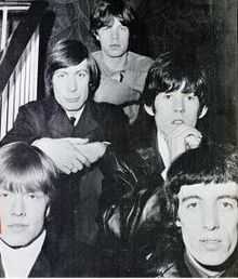
Historical note: The Rolling Stones
The Rolling Stones were spotted by a notable music promoter in 1963 at the then Red Lion public house (now the Winning Post) in Sutton High Street. The band played several early gigs there, and it was during a historic performance over half a century ago that the audience included impresario/music manager Giorgio Gomelsky, who spotted and signed the band up for a residency at Richmond's Crawdaddy Club, months before they made the charts and became stars.[93][94][95][96]
Charlie Watts and Bill Wyman also became permanent members of the band at the then Red Lion Pub on 23 January 1963.[97]
| “ | January 23, 1963: Charlie Watts and Bill Wyman become permanent members of the Rolling Stones with this day's gig at the Red Lion Pub in Sutton, Surrey. | ” |
In 2011, the Winning Post was added to a list of buildings and structures of local significance.[98][99]
Economy

Context
Sutton is one of the eleven major metropolitan centres identified in the London Plan[2] in a borough that benefits from very low crime by London standards. There are good public transport links through buses and trains and three main public car parks, as well as a "car club"—to reduce the need for local car ownership. Two of the car parks are located near the cinema and shopping area, and the third one, as well as the car club, is located near the main library, hotel and theatre.
Sutton has over 6,800 businesses, an increase of about 19% since 1994.[100] Statistics published in March 2013 by business analysts Duport have found that 863 new companies were formed in Sutton in 2012, the highest number since records began. Most of these are small or medium-sized enterprises, but several large businesses, such as Reed Business Information, the well-known media publishing company, are also present and have substantial office space in the town: Reed occupies the large Quadrant House office building adjacent to the mainline station, and is a major local employer.

G4S is another significant company in the town, with office accommodation in the large Sutton Park House commercial building opposite Manor Park. Crown Agents Ltd, the international development company, is headquartered in St Nicholas House in the town centre.[101] Another important business locally is Subsea 7, which is expanding its presence in the town through the construction of new offices.[102] Construction of the £39 million development by Galliford Try has started, and is expected to be completed by late Summer 2016.[103]
There is a town centre manager, who works in partnership with local businesses, the police and transport providers to promote the centre and its economic development. The manager acts as the focal point for putting into effect a range of initiatives funded by the Council and other partners. The initiatives are set out in a Business Plan approved by a representative Town Centre Management Group.[104] "Opportunity Sutton"[105] and Sutton Chamber of Commerce[106] also play a part in promoting economic development in the town.
Life Sciences
The Royal Marsden Hospital has a longstanding presence in Sutton, on a site at the southern end of the town acquired in 1962. The Institute of Cancer Research is located next to the hospital, and in November 2012 the Institute's Centre for Molecular Pathology opened.[107]

In March 2014, The Royal Marsden Hospital, the Institute of Cancer Research and the co-located St Helier University Hospitals NHS Trust set out their vision to develop a "world class" life science cluster on the site. The initiative, known as "Sutton for Life", includes the possible provision of enhanced facilities for drug discovery. Opportunity Sutton is developing plans with the partners for what has the potential to create 3,500 jobs on the site and a further 700 in the local economy.[108] The benefit to society of the work carried out at the Institute of Cancer Research led to its being named as the country's leading university, ahead of Imperial College, London School of Economics, Oxford and Cambridge.
The Mayor of London, Boris Johnson, visited the facility on 18 December 2014, and lent his support to the plans to create the world's second biggest cancer research campus on the site.[109] The mayor said:[110]
| “ | London is already a global capital of science.... a new life sciences campus at Sutton would be a real coup for the city and underline our reputation as the place to be for game-changing science. | ” |
Town centre regeneration
Sutton is set to gain hundreds of millions of pounds of investment in new mixed-use schemes in its high street area at both its northern and southern ends.
Sutton Point, worth around one hundred million pounds was granted planning approval in mid-2013, and developers CNM Estates started work on it in Spring 2014. At the southern end of the town centre, it will include a hotel, apartments (with a car club), a health club, shops, restaurants and office space.[102]
.jpg)
A major development by LXB Retail Properties PLC at the north end of the High Street area, including apartments, a Sainsbury's supermarket, a mix of retail units, a landscaped square and public art was approved in December 2013 after a public consultation process.[111] Work on site commenced in Spring 2014 for what will constitute the biggest single regeneration of the town centre in a generation. 463 full-time jobs will be created, when the project is completed in early 2016.[112]
Retailing
.jpg)
_south_end.jpg)

Retailing has long been a major part of the Sutton economy, with its High Street dating from the Victorian era. The oldest retail business currently operating in Sutton dates back to the 1860s – Pearson Cycles was originally a blacksmith shop, but in the 1890s changed to bicycle making and repair. The Pearsons have run the cycle business from the same High Street location ever since.[113]
Sutton town centre currently has over four hundred retail outlets occupying more than 120,000 square metres of floor space.[114] It is London's sixth most important retail centre, and attracts shoppers from a wide area. It is often the chosen location for new retail ventures.[115] An example of this is that the Sutton branch of the Waterstones bookshop chain was the first to have a café installed.[116]
Sutton High Street starts at Sutton Green and extends for nearly a mile south to Sutton mainline railway station, just beyond the junction with Grove Road. Many of the country's High Street names are represented in the central area.[117]
In recent years, two covered shopping centres have been added to the town, both situated in the central, High Street area. The larger is the St. Nicholas Centre with three levels, and five levels for Debenhams, the anchor store. It attracts an average of 20,000 visitors per day Monday to Sunday, 35,000 on Saturday, and twice these figures during December.[118] Times Square is the smaller of the two.[119] It opened in 1985, and was granted planning approval for a refit in June 2014; work is currently underway, with completion expected in early 2015.[119] The refit is assessed as being a "high quality refurbishment scheme which will make a significant contribution towards the regeneration of this part of the Town Centre."[120] It is expected to attract further major high street names.[121] Sutton also has a number of restaurants, patisseries, coffee bars, gastropubs, clubs and bars, including the country's first branch of All Bar One.[122] The central area is pedestrianised during shopping hours, and the extra space encourages cafés, pubs and restaurants to provide pavement seating.
.jpg)
Sutton's range of restaurants has expanded in recent years, and now includes examples of French, Spanish, British, Mexican, Malaysian, Thai, Pakistani, Portuguese, Turkish and Japanese cuisine, in addition to the more longstanding presence of Italian, Indian and Chinese establishments.[123][124] These include a French restaurant that is listed in The Good Food Guide[125] and is Michelin-listed.[126]
There are book retailers in the town centre, including Waterstones [127] and W H Smith.
There is a Green Wall, in the shopping area designed for aesthetics and to improve air quality and biodiversity. This "vertical garden" covers the façade of a large High Street store, and is in bloom all year round.[128]
The high street and town square host street performers, whose range includes live music, arts and theatre. Markets are held from time to time, including French, Italian and Continental markets, as well as arts and crafts fairs.[117]
In August and September the high street plays host to the outdoor "Sunset Cinema," where films are shown in the evening after the shops have closed to an audience seated in deckchairs.[129][130] The scheme, the only one of its kind in London, is designed in part to encourage patrons to utilise local restaurants and bars.[131]
Transport
_railway_station.jpg)

Sutton station is the town's major station, from where frequent direct trains run to several main central London stations − London Victoria, London Bridge, Blackfriars, City Thameslink and, for Eurostar services, St. Pancras International. The station is served by both First Capital Connect (for Thameslink) and Southern Railway.
The fastest of the Victoria-bound trains from Sutton station take 25 minutes (stopping only at Clapham Junction). As well as these direct trains to central London, there are also direct services to destinations outside central London including Banstead, Dorking, Epsom, Horsham, Leatherhead, West Croydon, Wimbledon, Luton and St Albans.
West Sutton and Sutton Common are both on the First Capital Connect lines to Wimbledon and on to central London direct. Being on the Thameslink line, they continue on to stations both within and the other side of London.
Local bus services are operated by London General, Epsom Coaches (Quality Line), Abellio London and Metrobus. There are also express coach services to both London Heathrow Airport and London Gatwick Airport.[132][133]
Road traffic is diverted away from a largely pedestrianised town centre, and there are many designated cycle routes in Sutton, along with links to neighbouring towns.[134]
As of mid-2014, a consultation was taking place into options for the route of a proposed Tramlink extension from Wimbledon to Sutton, with one option being to run the line down Sutton High Street.[135][136]
Notable individuals


See London Borough of Sutton for complete borough-wide list. The individuals listed below are specifically linked to the town of Sutton.
A to M
- Joan Armatrading, singer-songwriter & musician, lived in Sutton in the 1970s.
- Ben Barnes, actor, attended Homefield Preparatory School.
- David Bellamy, broadcaster and botanist, attended Sutton Grammar School.
- Sally Bercow, wife of the current Speaker of the House of Commons, John Bercow.
- Johnny Borrell, guitarist, singer and frontman of the band Razorlight.
- Noël Coward, actor and playwright, lived in Lenham Road, Sutton until the age of six
- James Cracknell OBE, Olympic gold medallist in rowing.
- Quentin Crisp, writer, author, raconteur was born in Sutton.
- Clark Datchler, lead singer of Johnny Hates Jazz.
- Catherine Holman, actress
- James Hunt, Formula One winning racing driver.
- Penelope Keith, actress, and famous for her role in The Good Life, was born in Sutton.
- Ruth Kelly, former Labour Party member of parliament and Transport Secretary, attended Sutton High School.
- Rebecca Litchfield, photographer.
- Bradley McIntosh, member of former chart topping band S Club 7, attended Greenshaw High School.
- Robbie McIntosh, guitarist.
- Katie Melua, award winning singer, songwriter and musician, lived in Gander Green Lane, Sutton.
- Phyllis Mudford King (1906-2006), Wimbledon ladies doubles winner 1931[137] attended Sutton High School.
N to Z
- Brian Paddick, the British Liberal Democrat politician, attended Sutton Grammar School for Boys.
- Peter Alfred Penfold, CMG, OBE,diplomat, attended Sutton Grammar School.
- Sidney Richard Percy, painter, lived in Mulgrave Road, Sutton.
- Conrad Pugsley, known as the Wizard Man of Sutton.
- Michael Reeves, film director and screenwriter, best known for the 1968 film Witchfinder General
- The Rolling Stones were discovered at the then Red Lion pub (now the Winning Post) in Sutton.[138] It was also at the pub that, on 23 January 1963, Charlie Watts and Bill Wyman became permanent members of The Rolling Stones.[139]
- Joanna Rowsell, Olympic gold medallist in women's pursuit cycling
- Dora Russell (born Dora Black, 1894-1986), author, feminist and progressive campaigner, attended Sutton High School.
- Sir Harry Secombe, the humourist, singer, comedian, entertainer and member of the Goon Show cast, was a local resident and personality. The Secombe Theatre in Sutton is named after him.
- Ian Stewart, co-founder of the Rolling Stones.
- Graham Sutherland, painter, etcher and designer, attended Homefield Preparatory School, Sutton.[140]
- Baron Tope of Sutton.
- Helen Young, BBC Weather Presenter and former BBC Weather Centre Manager
- Zacron, born Richard Drew, designer of the iconic Led Zeppelin III album cover.
Education
Schools


Sutton is the principal town in the London Borough of Sutton, a top performing borough for education. The town is home to a significant number of the borough's schools, including one of its boys' grammar schools, its boys' preparatory school and its girls' private secondary school.
Primary schools
|
|
Secondary schools
|
In 2013 Sutton's GCSE performance was second across all boroughs in England.[141] For more detailed information about performance see London Borough of Sutton.
Adult Education
The main centre of the Sutton College of Learning for Adults (SCOLA), originally named Sutton College of Liberal Arts, is based in Sutton. The college offers over 1000 part-time courses at its borough-wide centres.
Sport
Association football club Sutton United F.C. play in the Conference South league at Step 6 of the Football system, and famously beat Coventry City 2–1 in the FA Cup in 1989. Coventry City were then in Division 1 and winners of the contest two seasons previous. Sutton United's ground is in Gander Green Lane.
Sutton Cricket Club is based in Cheam Road. The Club’s 1st XI plays at the highest level of the sport available to it, the England and Wales Cricket Board’s ‘Surrey Championship Premier Division’ which they won in 2009. The club’s 2nd and 3rd teams also play at the highest level available to them, the ‘Surrey Championship 2nd XI and 3rd XI Premier Divisions’ with the 2nd XI having been league winners in 2009.[142]
References
- Notes
- ↑ http://data.london.gov.uk/2011-census-ward-pop
- ↑ 2.0 2.1 Mayor of London (February 2008). "London Plan (Consolidated with Alterations since 2004)" (PDF). Greater London Authority.
- ↑ 3.0 3.1 Visions of Britain
- ↑ 4.0 4.1 4.2 "Filmmaking renaissance for borough of Sutton". BBC. Retrieved 2 December 2013.
- ↑ Vision of Britain (historic studies website) data by settlement
- ↑ 6.0 6.1 6.2 Mills, D. (2000). Oxford Dictionary of London Place Names. Oxford.
- ↑ 7.0 7.1 Successful Sutton
- ↑ 8.0 8.1 8.2 8.3 8.4 8.5 8.6 8.7 Goodwins, Sara (2004). Sutton Past and Present. Sutton Publishing. ISBN 0-7509-3424-7.
- ↑ 9.0 9.1 bobulous.org.uk summary, collated medieval records
- ↑ 10.0 10.1 Youngs, Frederic (1979). Guide to the Local Administrative Units of England. I: Southern England. London: Royal Historical Society. ISBN 0-901050-67-9.
- ↑ British History: access to historic documents and studies sponsored by the University of Portsmouth and History of Parliament Trust
- ↑ H.E. Malden (editor) (1912). "The hundred of Wallington: Introduction and map". A History of the County of Surrey: Volume 4. Institute of Historical Research. Retrieved 27 November 2012.
- ↑ 13.0 13.1 Charles Harper (1922), The Brighton Road, Cecil Palmer, pp. 158–159
- ↑ 14.0 14.1 14.2 14.3 "Sutton Town Centre High Street Crossroads Conservation Area". Planning and Transportation Service Environment and Leisure, London Borough of Sutton. 2011. Retrieved 26 November 2014.
- ↑ Vision of Britain website
- ↑ Jones, Jane E M (2006). Sutton. Nonsuch Publishing. p. 15. ISBN 1-84588-324-1.
- ↑ Sutton Council document
- ↑ Sutton Council conservation area document
- ↑ Sutton Masonic Hall website
- ↑ Skinner, Julia (2006). Did You Know? Sutton and Cheam - A Miscellany. The Francis Frith Collection. p. 11. ISBN 978-1-84589-525-9.
- ↑ "Sutton: The railway makes a town". London Borough of Sutton. Retrieved 20 October 2014.
- ↑ London Borough of Sutton – Article
- ↑ The Workhouses website
- ↑ The Thomas Wall Centre
- ↑ Sutton Council Press Release Feb 2013
- ↑ Grant, Neal. Village London - Past and Present (2004 ed.). Bounty Books. pp. 205, 213. ISBN 0-7537-0840-X.
- ↑ "Plaque No. 10031 George Edgar Alcock". Open Plaques. Retrieved 21 October 2014.
- ↑ Government data
- ↑ NS Database
- ↑ http://www.waterplc.com/pages/about/a-brief-history/
- ↑ The ecclesiastical parish of Belmont
- ↑ Grid reference Finder measurement tools
- ↑ Bobulous website
- ↑ Southern Railway Ltd
- ↑ Sutton Lodge Day Centre website
- ↑ 36.0 36.1 36.2 36.3 36.4 36.5 Rookledge, Gordon (1999). Rookledge's Architectural Identifier of Conservation Areas - Sutton Edition. Sarema Press (Publishers) Ltd. p. 30. ISBN 1-870758-05-6.
- ↑ London Borough of Sutton — Article
- ↑ List of addresses in conservation areas
- ↑ Borough Heritage Study
- ↑ Open House London
- ↑ London Borough of Sutton — Article
- ↑ London Borough of Sutton — Article
- ↑ St Nicholas Church Grade II architectural listing Historic England. "Details from listed building database (1065629)". National Heritage List for England.
- ↑ London Borough of Sutton — Article
- ↑ Sutton Guardian
- ↑ St Nicholas Church
- ↑ English Heritage
- ↑ London Borough of Sutton — Article
- ↑ Diocese of Southwark
- ↑ Christ Church Sutton
- ↑ St Barnabas Church
- ↑ London Borough of Sutton — Article
- ↑ "London Borough of Sutton article : Manor Park, Located in the heart of Sutton : History". Sutton.gov.uk. Retrieved 17 October 2014.
- ↑ "Geograph website". Geograph.org. Retrieved 17 October 2014.
- ↑ "Geograph website". Geograph.org. Retrieved 17 October 2014.
- ↑ "London Borough of Sutton article : Manor Park, The name Manor Park suggests that this was originally the grounds of Sutton's Manor House". Sutton.gov.uk. Retrieved 17 October 2014.
- ↑ "World War One Cemeteries - Article". Ww1cemeteries.com. Retrieved 17 October 2014.
- ↑ "A new café made of straw! This exciting eco-friendly building is Manor Park Café". London Borough of Sutton. Retrieved 19 October 2014.
- ↑ "Three little pigs and a straw house - is Sutton becoming a fairytale?". Sutton Guardian. Retrieved 19 October 2014.
- ↑ "Local Nature Reserves: Search results for Greater London". Natural England.
- ↑ "Anton Crescent Wetland LNR". Retrieved 3 April 2014.
- ↑ "Devonshire Avenue Nature Area LNR". London Borough of Sutton. Retrieved 28 March 2014.
- ↑ Sutton Press Office
- ↑ 64.0 64.1 "London Borough of Sutton press office".
- ↑ Drostle and Turner fine tiles — Sutton Heritage page
- ↑ http://evamena.com/indeph-housesutton-londres-%C2%B7-2008diseno-y-ejecucion/
- ↑ http://suttonsouth.mycouncillor.org.uk/public-art-in-sutton-south/
- ↑ London Borough of Sutton Town Twinning page
- ↑ London Borough of Sutton press office
- ↑ Sutton Guardian article
- ↑ James Pepper (21 November 2012), Time stops in Sutton High Street after Armillery removed, YourLocalGuardian/Newsquest Media Group, retrieved 2014-08-22
- ↑ http://www.sutton.gov.uk/CHttpHandler.ashx?id=6991&p=0
- ↑ Public Monuments and Sculpture Association
- ↑ Wynne, David (1982). The Messenger: A Sculpture by David Wynne. Business Press International.
- ↑ Archer Sculpture — Gallery
- ↑ 76.0 76.1 "London Borough of Sutton article".
- ↑ "Google Maps". Retrieved 5 November 2014.
- ↑ "Folk-Lore of Women: Chapter XIV: Local Allusions to Women". sacred-texts.com. Retrieved 5 December 2013.
- ↑ "Deputy Prime Minister Nick Clegg officially opened Sutton Life Centre", Sutton Guardian, 27 October 2010. Retrieved 1 March 2011.
- ↑ London Borough of Sutton — Article on the Sutton Life Centre Retrieved 1 March 2011.
- ↑ "Lifetime award for pioneering centre 30.11.10". LBS Press Office. Retrieved 25 October 2014.
- ↑ "The Sutton Life Centre". Open House London. Retrieved 25 October 2014.
- ↑ http://www.suttontheatres.co.uk/
- ↑ "Sir Harry Secombe". Explore Gower. Retrieved 14 October 2014.
- ↑ Theatre Trust website
- ↑ Over the footlights website, regarding the Secombe Centre Theatre
- ↑ 87.0 87.1 "Dramatic rescue for Sutton's theatres as new 10-year takeover deal gets nod". Sutton Guardian. 21 January 2015. Retrieved 22 January 2015.
- ↑ UK Attractions website
- ↑ "The Granada Cinema, Carshalton Road, Sutton, Surrey - Now London". arthurlloyd.co.uk. Retrieved 2 March 2013.
- ↑ http://www.theiac.org.uk/eventsnew/biaff/biaff2014/special-awards.html
- ↑ http://www.suttonguardian.co.uk/news/11110928.Hollywood_beckons_for_award_winning_Sutton_film_maker/?ref=eb
- ↑ http://www.suttonsymphonyorchestra.org
- ↑ Dr R F Schwartz. How Britain Got the Blues: The Transmission and Reception of American Blues Style in the United Kingdom. Ashgate Publishing, Ltd. p. 149.
- ↑ London History Tours, Adrian Sill, Jeremy Tipton. "The Stones at the Red Lion". Shadyoldlady.com. Retrieved 19 December 2013.
- ↑ "Pub home to music legends is preserved". Croydon Advertiser. 13 May 2011.
- ↑ Schwartz, R. F. (2013). How Britain Got the Blues: The Transmission and Reception of American Blues Style in the United Kingdom. Ashgate Publishing, Ltd. ISBN 9781409493761.
- ↑ Ian McPherson. "Chronicle 1963". Timeisonourside.com. Retrieved 19 December 2013.
- ↑ "'Rolling Stones' pub joins heritage list (From Your Local Guardian)". Yourlocalguardian.co.uk. 13 May 2011. Retrieved 15 February 2014.
- ↑ "A CELEBRATED music pub which helped the Rolling Stones on their road to fame will be preserved for posterity.". Croydon Advertiser. 13 May 2011. Retrieved 15 February 2014.
- ↑ London Borough of Sutton — Businesses
- ↑ Crown Agents website
- ↑ 102.0 102.1 "Sutton station path to close next week as work starts on three town centre projects (From Sutton Guardian)". Suttonguardian.co.uk. Retrieved 5 April 2014.
- ↑ "Galliford Try begins work on new offices in heart of Sutton". Retrieved 25 October 2014.
- ↑ London Borough of Sutton — Article
- ↑ http://www.opportunitysutton.org/
- ↑ Sutton Chamber of Commerce - building local business
- ↑ Royal Marsden Centre for Molecular Pathology
- ↑ London Borough of Sutton Press Release March 2014
- ↑ Sutton Guardian
- ↑ Sutton Borough Press Office
- ↑ "Sutton town centre gateway project the Old Gasworks given go-ahead". Newsquest. Retrieved 20 December 2013.
- ↑ London Borough of Sutton Press Release Feb 2014
- ↑ "History of Sutton Town Centre". Successfulsutton.co.uk. Retrieved 5 December 2013.
- ↑ "Economic Development and Areas of Regeneration". London Borough of Sutton. Retrieved 21 October 2014.
- ↑ "Where is Sutton?". London Borough of Sutton. Retrieved 21 October 2014.
- ↑ "Waterstones rolls out Café W". PeachesReport. Retrieved 20 September 2014.
- ↑ 117.0 117.1 London Borough of Sutton – What Sutton Town Centre has to Offer
- ↑ "Business Opportunities". London Borough of Sutton. Retrieved 21 October 2014.
- ↑ 119.0 119.1 "Times Square Shopping Centre". Times Square, Sutton. Retrieved 4 December 2013.
- ↑ Sutton Modern Government
- ↑ http://www.suttonguardian.co.uk/news/11282852.Times_Square_in_Sutton_High_Street_set_for_makeover/?ref=mr
- ↑ Mitchells and Butlers — All Bar One a history of the franchise
- ↑ "Restaurants near Sutton (Surrey) Station - find the best restaurants near Sutton (Surrey) Station with Square Meal reviews". Squaremeal.co.uk. Retrieved 27 February 2014.
- ↑ "Sutton, United Kingdom Restaurants: See 82 restaurants with 1,343 reviews". TripAdvisor. Retrieved 27 February 2014.
- ↑ Carter, Elizabeth (2012). The Good Food Guide 2013. The Good Food Guide. p. 166. ISBN 978-1-84490-136-4.
- ↑ "Brasserie Vacherin ViaMichelin : Useful information and online user reviews". Viamichelin.co.uk. 4 October 2013. Retrieved 13 January 2014.
- ↑ https://plus.google.com/118434313974693318509/about?gl=uk&hl=en
- ↑ London Borough of Sutton
- ↑ Sutton Guardian
- ↑ Successful Sutton
- ↑ London Borough of Sutton Press Release July 2013
- ↑ "Buses from Sutton" (PDF). Transport for London. Retrieved 7 December 2013.
- ↑ "A3" (PDF). Busmap.co.uk. Retrieved 8 December 2013.
- ↑ https://www.sutton.gov.uk/index.aspx?articleid=4109
- ↑ http://www.newsroomsutton.co.uk/?p=746
- ↑ http://www.suttonguardian.co.uk/news/11357417.Have_your_say_on_Wimbledon_to_Sutton_Tramlink_extension_as_four_possible_routes_are_revealed/?ref=var_0
- ↑ "Phyllis King: Hard-hitting ladies doubles champion at Wimbledon in 1931". The Times. 2006-02-02. Retrieved 2007-10-24.
- ↑ http://www.shadyoldlady.com/location.php?loc=2521#
- ↑ http://www.timeisonourside.com/chron1963.html
- ↑ Chris Beetles. "G Sutherland biography".
- ↑ Evening Standard
- ↑ Sutton Cricket Club
- Bibliography
- Charles J. Marshall (1971). History of Cheam & Sutton. S.R. Publishers Ltd. ISBN 0-85409-649-3.
- Robert P. Smith (1970). A History of Sutton AD 675–1960. Published by Derek W. James, no ISBN.
- Martin Andrew (2001). Around Sutton. Frith Book Company Ltd. ISBN 1-85937-337-2.
Further reading
- James Thorne (1876), "Sutton", Handbook to the Environs of London, London: John Murray
- Edward Walford (1883), "Sutton", Greater London, London: Cassell & Co., OCLC 3009761
- H.E. Malden (editor) (1912), "Sutton", A History of the County of Surrey: Volume 4
External links
| Wikimedia Commons has media related to Sutton, London. |
- London Borough of Sutton - Sutton: The railway makes a town
- Manor Park (1927). Three minute amateur film shot in 1927 from Sutton Local Studies and Archive showing various aspects of Sutton town centre, including people at leisure in Manor Park and a policeman directing traffic at the main crossroads.
- Sutton Carnival Procession (1933). Three minute film from 1933 covering spectators in Mulgrave Road near Sutton railway station and a carnival procession, which includes a fire engine and several floats from a range of organisations and businesses.