Sutla
| Sotla / Sutla | |
|---|---|
 | |
| Mouth | Sava 45°51′52″N 15°41′01″E / 45.8645°N 15.6835°ECoordinates: 45°51′52″N 15°41′01″E / 45.8645°N 15.6835°E |
| Basin countries | Slovenia, Croatia |
| Length | 89 km (55 mi)[1] |
| Source elevation | 580 m (1,900 ft)[2] |
| Mouth elevation | 135 m (443 ft)[2] |
| Basin area | 584 km2 (225 sq mi)[1] |
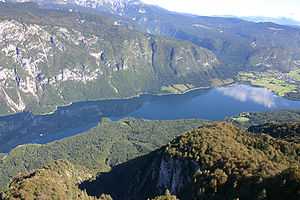
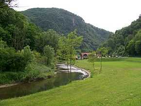
The Sutla (Croatian) or Sotla (Slovene) is a river flowing through Slovenia and Croatia, mostly forming their border. It is a tributary to the Sava, itself a tributary to the Danube. It is 89 kilometres (55 mi) long and has a watershed area of 584 square kilometres (225 sq mi).[1]
The Sutla flows through the following municipalities:
- in Slovenia: Rogatec, Rogaška Slatina, Podčetrtek, Bistrica ob Sotli, Brežice
- in Croatia: Đurmanec, Hum na Sutli, Desinić, Zagorska Sela, Klanjec, Kraljevec na Sutli, Brdovec
The hydrological parameters of the Sutla are regularly monitored in Croatia at Zelenjak.[3]
The division of the Sutla/Sotla basin area between Croatia and Slovenia is inconsistent in sources - Croatian sources claim either 343 km2 (132 sq mi)[4] or 455 km2 (176 sq mi),[5] while Slovenian sources claim either 477 km2 (184 sq mi)[6] or 451 km2 (174 sq mi)[2]
The Kozje Park (Slovene: Kozjanski park), established in 1981 as the Trebče Memorial Park (Spominski park Trebče), is located in the Slovenian territory to the west of the Sotla. It covers 206 km2 (80 sq mi) of the landscape of Kozje Hills (Kozjansko hribovje), including wetlands along the Sotla. It is the habitat of over 120 bird species and of about 950 higher plant species.[7]
References
- ↑ 1.0 1.1 1.2 "Main Hydrographic Features in the Sava River Basin". Sava River Basis Analysis Report (PDF). Zagreb: International Sava River Basin Commission. September 2009. p. 13.
- ↑ 2.0 2.1 2.2 "Reke, dolge nad 25 km, in njihova padavinska območja" [Rivers, longer than 25 km, and their catchment areas] (in Slovene and English). Statistical Office of the Republic of Slovenia. 2002.
- ↑ "Daily hydrological report". Croatian Meteorological and Hydrological Service. Retrieved 2010-09-09.
- ↑ "Rivers" (PDF). Statistical Yearbook (Croatian Bureau of Statistics): 43. 2011. ISSN 1333-3305. Retrieved 2012-04-18. (printed edition; ISSN 1334-0638 for the online edition)
- ↑ "Karakteristike značajnijih vodotoka". Vodnogospodarska osnova Hrvatske - Strategija upravljanja vodama (in Croatian). Croatian Parliament. Retrieved 2011-12-19.
- ↑ Visokovodni valovi – Sotla nad Draganjo in Draganja na izlivu (delovna verzija). Elaborat, Vodnogospodarski inštitut. Ljubljani, 2000.
- ↑ Bizjak, Janez (2008). Zavarovana območja v Sloveniji [Protected Areas of Slovenia] (PDF) (in Slovene and English). Ministry of the Environment and Spatial Planning, Republic of Slovenia. ISBN 978-961-6392-61-7.
| ||||||||||||||||||
| ||||||||||||||||||||||||||||||||||||