Suontee
| Suontee | |
|---|---|
 | |
| Location | Joutsa, Hirvensalmi and Pertunmaa |
| Coordinates | 61°39.21′N 026°29.66′E / 61.65350°N 26.49433°ECoordinates: 61°39.21′N 026°29.66′E / 61.65350°N 26.49433°E |
| Type | Lake |
| Catchment area | Kymijoki |
| Basin countries | Finland |
| Max. length | 38 km (24 mi) |
| Surface area | 149 km2 (58 sq mi) |
| Average depth | 8.8 m (29 ft) |
| Max. depth | 77 m (253 ft) |
| Water volume | 0.7 km3 (0.17 cu mi) |
| Shore length1 | 627.254 km (389.758 mi) |
| Surface elevation | 94 m (308 ft) |
| Frozen | December-April |
| Islands | Joussaari, Isosaari, Mankinsaari, Kuivassaari |
| 1 Shore length is not a well-defined measure. | |
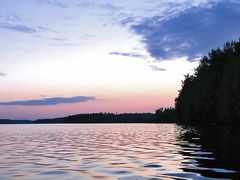
Suontee (also: Suonteejärvi) is a rather large lake of Finland. The northern part of the lake is located in the region of Central Finland, and the southern part in the region of Southern Savonia. The southern part is on more natural state with very clear water, and it is included in the Natura 2000 conservation network of EU. The protection area is 2 625 hectare wide. Typical bird there is Black-throated Loon. In the history two big lakes Suontee and Puula were one lake until year 1854, when the water level was lowered 2.5 meters. This has brought up geological stacks, which are formed by water.
See also
- List of lakes in Finland
References
- Suontee in Järviwiki. Accessed 10th of Feb 2014. (English)
- Natura-area of Suontee. Finnish Environmental Administration. Accessed 10th of Feb 2014. (Finnish)
External links
![]() Media related to Suontee at Wikimedia Commons
Media related to Suontee at Wikimedia Commons
-
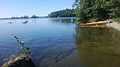
Kayaking in Suontee
-
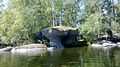
Water has formed geological stacks in Suontee
-
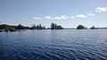
Little islands